Analyzing Results for the HEC-FIA Holdouts Methodology
The HEC-FIA holdouts method calculates FDR directly within the model run. Most of the effort in this workflow involves validating the total damage results and understanding how FDR values are derived from multiple model computes.
Accessing FDR Reports
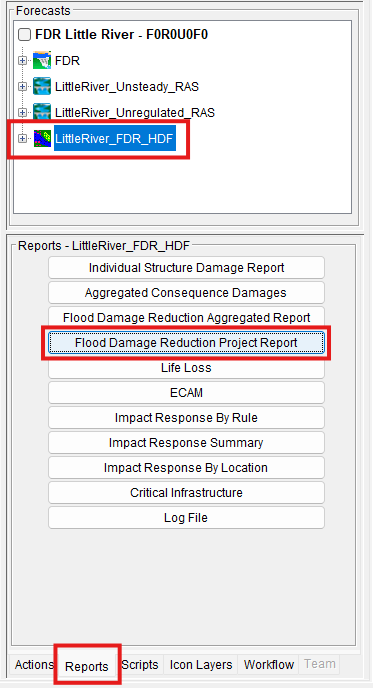
Once the CWMS forecast is successfully computed, you can view the HEC-FIA results directly from the CAVI. Select the HEC-FIA model alternative and click on the Reports tab to access the appropriate reports (e.g., Flood Damage Reduction Project Report, Flood Damage Reduction Aggregated Report).
Reviewing Total Damage Results
AFDR is calculated by comparing damages across different simulation conditions (e.g., regulated vs. unregulated). Therefore, the first step in interpreting your results is to verify the total damage values from each individual compute. This helps ensure that the results make sense given the extent and depth of inundation.
Carefully reviewing these values can uncover a wide range of issues—not just within HEC-FIA, but also in the upstream models, such as:
- Incorrect boundary conditions in HEC-RAS
- Errors in model linking
- Unrealistic water surface elevations or flood extents
Since AFDR results are generated from comparing individual damage computes, interpreting the results starts with reviewing and verifying those damage computes. This review confirms total damage results from each compute are reasonable given the inundation data for the event. This review leads to uncovering errors not only confined to the HEC-FIA setup, but also errors in other models setup (i.e., bad boundary conditions and incorrect model linking).
Using the Aggregated Report to Spot Issues
HEC-FIA includes a Flood Damage Reduction Aggregated Report, which is a valuable tool for examining model outputs. This report shows:
- Total damages and damages reduced for each compute
- Results by default aggregated to holdout areas
- Optional aggregation by custom shapefile boundaries (e.g., state, county, or USACE district)
The right side of the table displays the AFDR values, which are affected by the precedence logic you select. More on that is covered later in this guide.
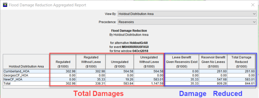
As you review the compute results, watch for red flags such as:
- Unexpectedly high or low damages in specific areas
- Regulated damages higher than unregulated, which leads to negative FDR values
- Unrealistic without-levee damages, possibly indicating errors in the without-levee scenario setup
These anomalies often point to specific issues in the model setup or data inputs.
Investigating Results Using Spatial Data
To pinpoint issues, use GIS to explore the spatial output shapefiles generated by each compute. These files follow a naming convention based on the simulation type:
- Reg_ – Regulated
- Unreg_ – Unregulated
- UnregWOL_ – Unregulated Without Levee
- RegWOL_ – Regulated Without Levee
By opening these shapefiles in GIS software like ArcGIS Pro, you can inspect:
- The location and extent of damage
- Inundation depths at structures
- Damage types (structure, contents, vehicles, etc.)
Overlaying Hydraulic Inputs and Inundation Grids
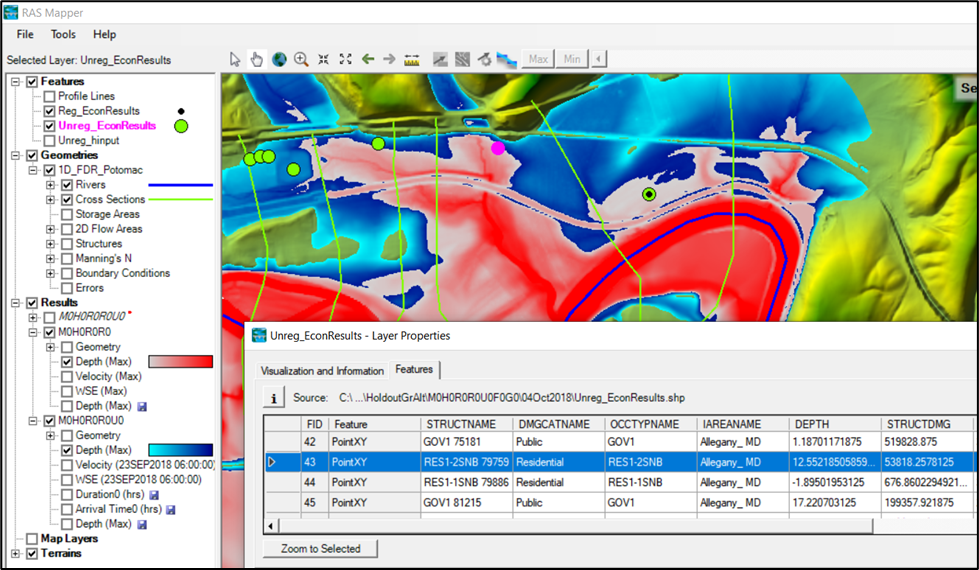
HEC-FIA also generates a hydraulic inputs shapefile (Hinputs), which includes the computed water surface elevations (WSE) and terrain elevations for each structure.
A best practice is to overlay this data with:
- Inundation grids from HEC-RAS
- Damage result shapefiles from HEC-FIA
This comparison helps confirm that the hydraulic data used to compute damages is accurate and consistent with modeled flood extents.
The figure below demonstrates how to use HEC-RAS Mapper to visually compare damage locations with the inundation boundaries, offering a powerful QA/QC step in the AFDR workflow.
Interpreting the Flood Damage Reduction Aggregated Report
Once you've verified that the total damage results from all four computes are reasonable, you can move on to interpreting AFDR results using the Flood Damage Reduction Aggregated Report and the Flood Damage Reduction Project Report in HEC-FIA.
How AFDR is Calculated in the Holdouts Method
In the HEC-FIA holdouts approach, flood damages are apportioned to reservoir and levee projects based on the location of each structure:
- Holdout Areas define how a structure’s damage is split among upstream reservoir projects.
- If a structure is also within a leveed area, its damages may be further attributed to the levee project protecting that area.
The total damages reduced across the modeling domain are calculated by subtracting damages in the Regulated scenario (reflecting real-world operations) from those in the Unregulated Without Levee scenario (representing the worst-case flood). This difference is shown in the rightmost column of the aggregated report, with the overall AFDR value displayed at the bottom.
Project Precedence: Resolving Levee vs. Reservoir Overlap
A common modeling challenge arises when both levees and reservoirs contribute to protection in the same area. Since it's not always clear how to split the benefit between the two, HEC-FIA allows you to choose which project type takes precedence when allocating damages reduced.
You can select either reservoir precedence or levee precedence from a dropdown menu in the Aggregated Report.
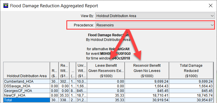
For whichever project type is given precedence—levee or reservoir—the associated benefits are calculated as if the other project type did not exist. The tables below provide a detailed breakdown of how these calculations are performed for each precedence scenario.
Reservoir Precedence | |
|---|---|
Result | Equation |
Levee Benefit (Given Reservoirs Exits) | = Regulated Without Levee - Regulated |
Reservoir Benefit (Given No Levees) | = Unregulated Without Levee - Regulated Without Levee |
Total Damage Reduced | = Unregulated Without Levee - Regulated |
Levee Precedence | |
|---|---|
Result | Equation |
Levee Benefit (Given No Reservoirs) | = Unregulated Without Levee - Unregulated |
Reservoir (Benefit Given Levees Exist) | = Unregulated - Regulated |
Total Damage Reduced | = Unregulated Without Levee - Regulated |
The total damage reduced is the same in both cases. What changes is how it's divided between levees and reservoirs.
Future versions of HEC-FIA will support a weighted average method to more fairly apportion benefits between levees and reservoirs, eliminating the need to choose a strict precedence.
Interpreting the Flood Damage Reduction Project Report
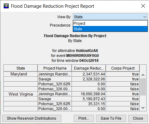
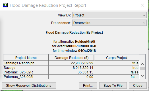
The Flood Damage Reduction Project Report displays how much damage was reduced by each individual reservoir or levee project within the modeling domain. This report is especially useful when you need to report AFDR values by project.
For levees, the benefit for each one is calculated based on the selected precedence. For reservoirs, benefits are allocated using one of two methods, holdouts or overrides.
Methods for Allocating Reservoir Benefits
When multiple reservoirs reduce damages at downstream locations, the total damages reduced by reservoirs must be divided among the individual contributing reservoirs. HEC-FIA provides two ways to accomplish this.
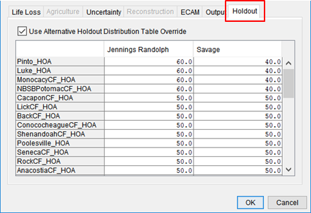
Manual Allocation (Custom Percentage)
You can manually assign damage reduction percentages for each reservoir in each holdout area. This is especially useful if your district uses a legacy allocation method. You can configure this in the HEC-FIA Alternative Editor.
Flow-Based Allocation (Recommended)
A more automated and data-driven method uses routed holdout flows at Control Computation Points (CCPs) to proportionally assign damages:
- For each CCP, HEC-FIA compares the peak holdout flow from each contributing reservoir.
- The reservoir's contribution is divided by the total holdout flow at that point to calculate its allocation percentage.
- These percentages are applied to distribute damages across the reservoirs in that holdout area.
You can review these allocations in the Reservoir Allocation Table within HEC-FIA.

Aggregating by Geographic Boundaries
For reporting purposes, you can also aggregate damages by shapefile boundaries directly in the Project Report. This is particularly helpful when AFDR data needs to be reported by state, county, or USACE district.
To do this:
- Load your shapefile (e.g., state boundaries) into HEC-FIA.
- Use the dropdown in the Flood Damage Reduction Project Report to aggregate results by the selected geography.
- The results update automatically based on the selected layer.
The figure below shows an example of viewing AFDR results by state.
