How to Add Crop Data in HEC-FIA
Goal: Walk through the steps to add Crop data to an HEC-FIA model. Agriculture data can be used within a Flood Damages Reduced simulation (in HEC-FIA 3.4) or a single-event HEC-FIA simulation.
Tasks in Tutorial:
- Download Crop Layer
- Adding Agricultural Grid to HEC-FIA
- Adding Data to the Crop Loss Editor
Agriculture Inputs Required:
- Spatial Crop Layer - readily available for download for the continental US from the USDA National Agricultural Statistics Service Cropland Data Layer (NASS CDL)
- Raster grid that contains crop/non-crop attributes at a 30 meter resolution. Steps to download for the extents of your HEC-FIA model included below
- Crop Budget - Defines plant dates as well as fixed and variable monthly production costs per acre for each crop selected from the NASS CDL
- Seasonal Duration-Damage Curve - Monthly value that defines the percent crop loss relative to the number of days inundated
- Harvest Data - Harvest date, cost per acre, yield per acre, units of harvest (bushels, boxes, tons, etc), unit price, and percent loss from late planting.
Crop budgets, seasonal duration-damage curves, and harvest data are regionally dependent, and the availability of data varies widely throughout the country. Consult with district economists, universities, and regional USDA offices for potential data sources.
1. Download Crop Layer
- Create an "Area of Interest" polygon that can be used to extract the crop data from the National dataset
- Polygon should cover the extents of the hydraulic inputs (can be created in RAS Mapper)
- Open RAS Mapper for the associated CWMS HEC-RAS project
- As shown in the image below, right click on the geometry and create a polygon shapefile of the geometry region (make sure RASMapper as a projection!)

- Navigate using Windows File Explorer to the location of the extent shapefile. Highlight all the shapefile files (.shx, .dbf, .prj, .shp) and compress into a .zip file.

- Open the USDA Cropscape website - https://nassgeodata.gmu.edu/CropScape/
- Click on "Import Area of Interest" to bring up the dialog box shown in the image below.

- Browse to the extent .zip file and click "Upload" and then "Ok". Wait for the Area of Interest to appear in the turquoise as shown in the image below.
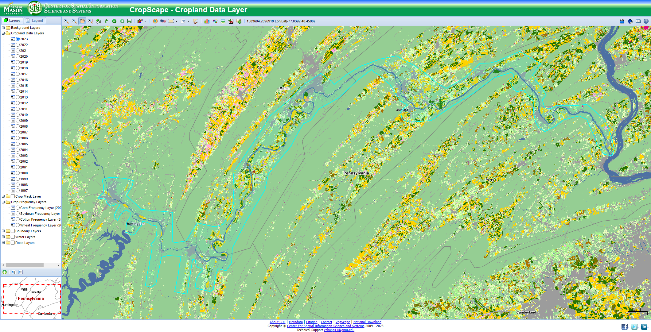
- Next click on "Download Defined Area of Interest" and select the year of data desired. For CWMS watersheds, make sure to select "Specify Projection", and select "USA Contiguous Albers Equal Area Conic USGS". Click "Submit" and save to your computer.

2. Adding Agriculture Grid to HEC-FIA
- Extract the Agriculture Grid .zip downloaded in the previous step to a location on your computer.
- Open the HEC-FIA project. The NASS CDL agriculture grid is entered via the Study Directory.
- Begin by right-clicking "Agricultural Grids", and clicking on "Load NASS CDL Grid", as seen below.
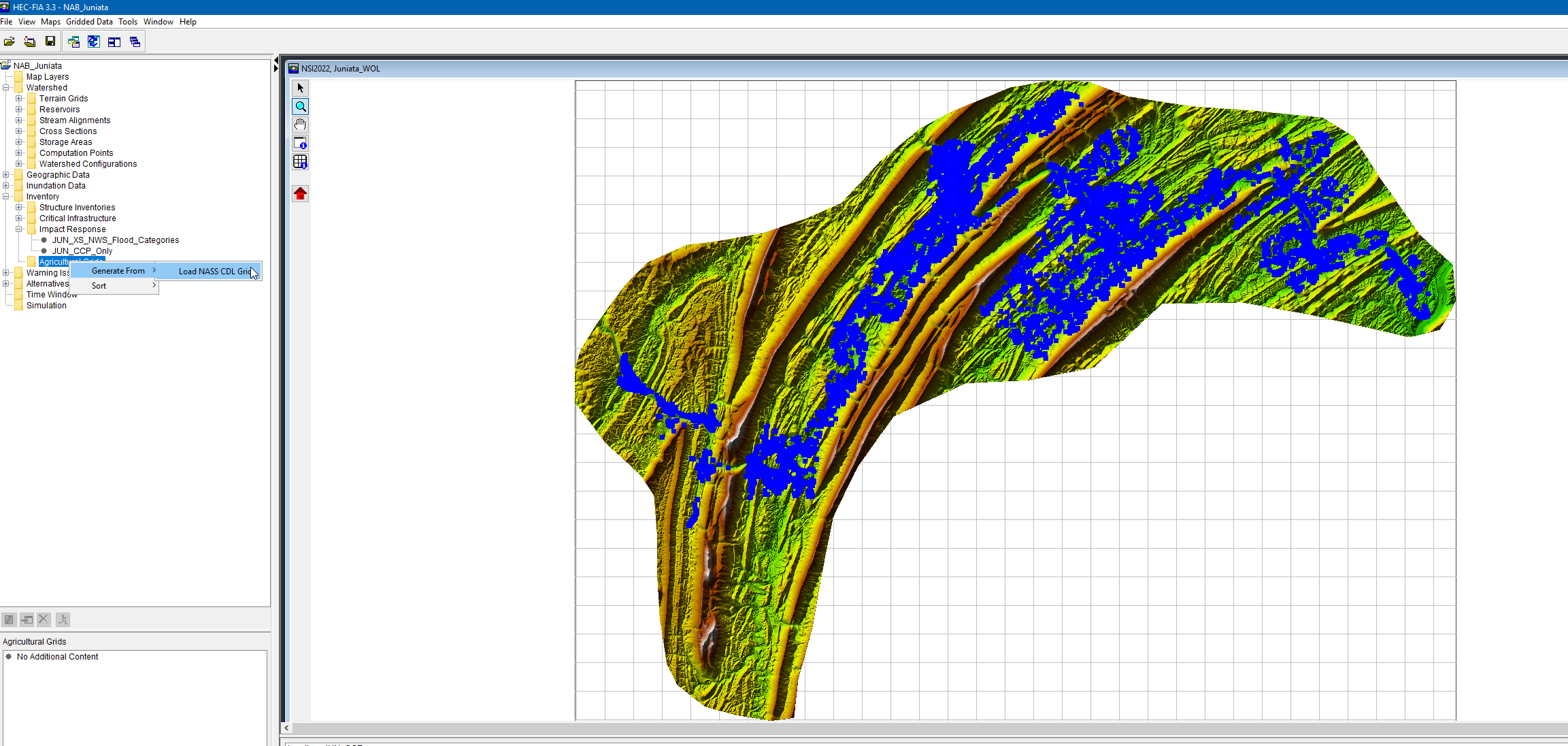
- This will open the Import Crop Data Box.
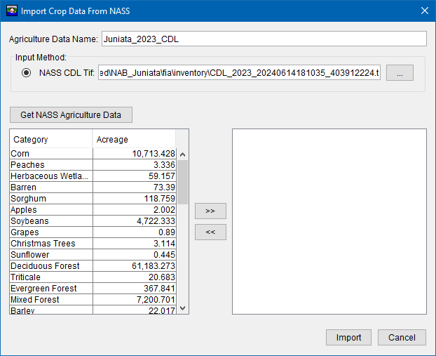
- Enter a Descriptive Name in the "Agriculture Data Name"
- Select the "NASS CDL Tif" Button, and then navigate to the unzipped CDL grid that was previously extracted from the Cropland website
- Click the "Get NASS Agriculture Data" Button. This will populate the "Category" and "Acreage" data from the .tif file.
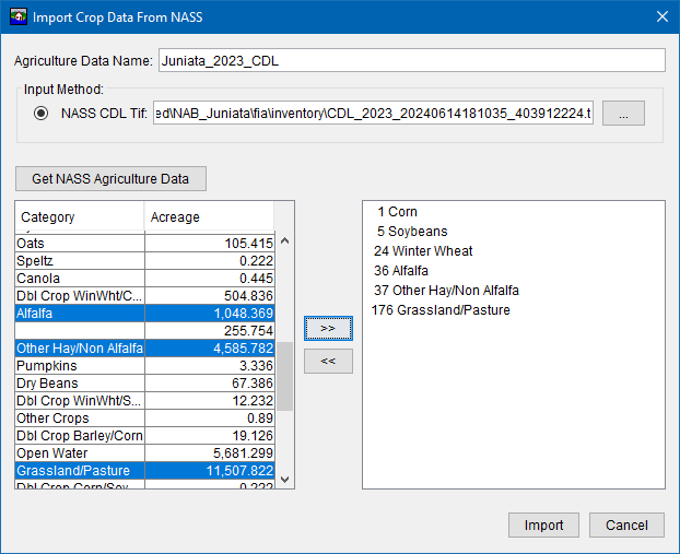
- Select the applicable crops, keeping in mind that crop loss data will need to be developed for each crop selected.
- Click the ">>" button to finish the selection.
- Click "Import" to import the selected crops into HEC-FIA.
- The Ag grid has now been added to the FIA Map window as seen below. (Note the terrain has been turned off in the image below to better show the Ag Grid).

3. Adding Data to the Crop Loss Editor
- Right Click the Ag Grid Name and press "Edit" to open the Crop Loss Editor Box. This is this where plant dates, monthly production costs, harvest data, and seasonal duration-damage curve data is entered.
