CWMS-RAS Tips
Upgrading your HEC-RAS Model in CWMS
The best practice for upgrading your HEC-RAS model in CWMS is to ensure your RAS alternatives run in base. This also includes creating the stored maps (such as depth grids) in the base watershed that are used in FIA computations.
Ensure your base model has all the data available to run contained within the watershed: input DSS data, terrain, projection, land use etc. A good place to store this data is in a "Data" directory created in the "ras" directory. Once that data is there, ensure your RAS project is setup to utilize it.

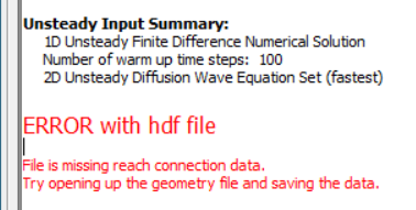
Reach Connection Data in Geometry File
If your geometry contains 1D-2D direct connections (ie a 2D area directly connected to a 1D river reach), you will have to save the geometry in the latest version to ensure the connection data is written to the geometry hdf file. The error message in the RAS Compute Window indicates this.
Missing Observed Data

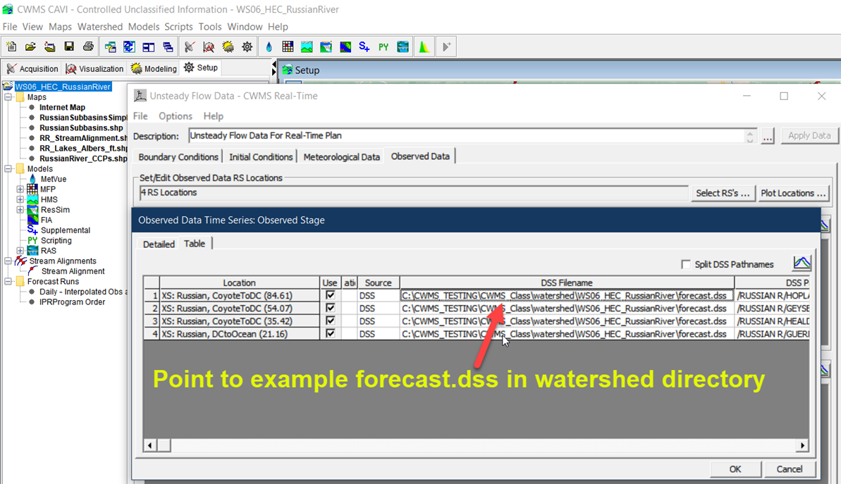
If observed data was setup in your HEC-RAS Unsteady Flow Editor so that it can be viewed in forecasts, those links may be broken upon updating to the latest HEC-RAS. Fortunately this is an easy fix.
- Copy an example forecast.dss file that contains the observed data into the watershed's base directory.
- Edit observed data for the base HEC-RAS model. In the HEC-RAS unsteady Flow editor and use the example forecast.dss as the source file.
HEC-RAS now stores this as a relative path so when forecasts are created the source DSS file is the proper forecast.dss file.
Known Issues:
Automatic Generation of Stored Maps during Compute fails if Alternative Terrain is Selected
If the user specifies an alternative terrain for the Saved Maps such as Max Depth, in RAS Mapper (IE a re-sampled terrain different than the terrain used for computations) then the Saved Maps won't be automatically created during the compute even if the Floodplain Mapping Box was checked for the simulation.
Workaround: After simulation finishes computing, open RAS Mapper and manually compute/update stored maps. This is good practice anyway for the modeler to review output from RAS before saving the stored maps to disk.
If a standalone RAS model is open and a users launches CAVI and opens a watershed, the standalone model will close.
This has been a long standing issue within HEC-RAS.
Using the Action Buttons in a CAVI forecast to access HEC-RAS editors (Plan Data, Geometry Data, etc.) can cause issues when there are multiple HEC-RAS plans in a forecast.
When using the Action Buttons to switch back and forth between multiple RAS plans the geometry files may get overwritten. To avoid this, only access RAS geometry editors by launching the RAS plugin.