Correcting the HEC-HMS Schematic Display in HEC-RTS
The way that HEC-RTS and HEC-HMS display model elements in their respective maps is fundamentally different. HEC-HMS draws the schematic based on the X,Y coordinates of each model element, whereas HEC-RTS draws model elements relative to their position on the stream alignment. This difference can cause issues when HEC-HMS models are imported into an HEC-RTS watershed.
This guide will explain how to identify issues with the HEC-HMS schematic in your HEC-RTS watershed and how to use tools in HEC-RTS to correct those issues.
Model Schematic Background Information
HEC-HMS and HEC-RTS differ in how they draw model elements:
- HEC-HMS places elements based on their X,Y coordinates in the model's map space. It does not enforce alignment with natural stream paths.
- HEC-RTS, however, places junctions and reaches based on their position along a stream alignment, which represents the actual river network.
Junctions
HEC-RTS uses a shared schematic rule for junctions:
- If an HEC-ResSim junction with the same name exists, only the HEC-ResSim junction is shown. HEC-RTS will mark it as shared by both HEC-ResSim and HEC-HMS.
- If no matching ResSim junction exists, HEC-RTS uses the X,Y location of the HEC-HMS junction and snaps it to the nearest stream in the stream alignment.
This snapping works best if the same stream alignment shapefile was used as a background in HEC-HMS and the junctions were carefully placed.
Reaches
Reaches follow similar shared schematic rules:
- If multiple models (e.g., HEC-HMS, HEC-ResSim, HEC-RAS) have reaches on the same stream segment, only one reach is drawn, but all model associations are preserved.
- For example, right-clicking on different parts of the reach may show different model options.
HEC-RTS uses the X,Y coordinates of the reach’s endpoints to place it on the stream alignment. It applies rules that HEC-HMS does not:
- Reaches are drawn from upstream to downstream.
- A reach from a tributary cannot extend beyond its confluence with the mainstem.
- The upstream endpoint is snapped to the nearest stream. That stream becomes the reach’s assigned stream.
- HEC-RTS then attempts to locate the downstream endpoint on the same stream.
- If the endpoint snaps to a different stream, the reach may appear incomplete or end early.
- A reach cannot cross stream junctions to a different stream. If this happens, it will be truncated at the confluence.
Reservoirs
Reservoirs follow the same shared schematic rule as junctions:
- If a HEC-ResSim reservoir with the same name exists, only the HEC-ResSim version is drawn and marked as shared.
- If no matching HEC-ResSim reservoir exists, HEC-RTS displays the HEC-HMS reservoir icon at its X,Y location.
Other HEC-HMS Elements
All other elements from HEC-HMS (e.g., subbasins, sources, sinks) are drawn at their X,Y coordinates as defined in the HEC-HMS model. Stream alignment is not used for these elements.
Step 1: Identify Missing or Misplaced Reaches
Missing reaches are the most obvious problem when the HEC-HMS alternative's schematic is drawn on the HEC-RTS map. However, if you look closely, you'll find that there's actually more to it - those missing reaches actually are drawn somewhere in the schematic. At first glance, you may not see them because they are being drawn in the wrong place or may be coincident with other reaches. Most often, a reach may be misdrawn because one of its endpoints does not snap to the same stream in the stream alignment as the other endpoint of the reach.
To identify missing reaches:
- Launch HEC-RTS and open your watershed.
- Navigate to the Setup tab.
- In the Watershed Tree:
- Right-click the Stream Alignment and select Display in Map Window.
- Right-click the HEC-HMS forecast alternative you're working on and select Display in Map Window.
- Click the HEC-HMS icon in the toolbar to launch HEC-HMS.
- In HEC-HMS, open the basin model associated with the forecast alternative you selected previously.
- In both HEC-HMS and HEC-RTS:
- Zoom in on each stream.
- Compare the reach layout in both map windows.
- In the HEC-RTS map window, identify reaches that are:
- Missing
- Drawn incorrectly
- Drawn on the wrong stream
- Start a "Problem Reaches" list with the following columns:
- Reach Name
- Upstream Junction
- Downstream Junction
- If a reach does not connect to a junction, estimate where it should connect by identifying a “good enough” stream station value.
While doing this, also take note of any "misplaced junctions" and begin a second list:
Junction Name
- Stream Name
- Approximate Stream Station
Step 2: Identify and Correct Misplaced Junctions
Misplaced junctions are a common cause of misdrawn reaches. Fixing them usually resolves several reach display issues.
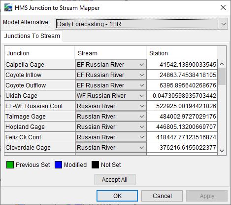
Use the Junction Location Mapper:
- From the Setup tab, go to the Models menu and select HMS → Junction Location Mapper.

- Choose the HEC-HMS forecast alternative you're correcting from the dropdown menu.
- For each junction listed:
Check if it’s assigned to the correct stream.
Pay close attention to junctions located at stream confluences—these are often misaligned.
Rule of thumb: A junction at a confluence should belong to the stream that continues downstream.
- Add all incorrectly located junctions to your "misplaced junctions" list.
- Close the dialog.
You can’t fix the junction just yet—you need the correct stream and stream station.
Step 3: Determine Correct Junction Locations
To find the correct stream and station for each junction:
- Select the Stream Node Tool in the map toolbar.
- For each junction on your "misplaced junctions" list:
- Zoom in to the correct location on the stream alignment.
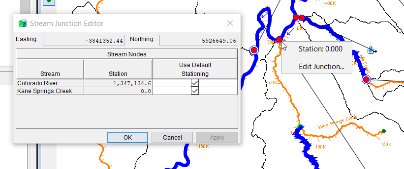
- Right-click on the correct stream node or confluence and select Edit Junction.
- In the Stream Junction Editor:
- Identify the mainstem stream (has a non-zero station).
- Record the stream name and station for the mainstem. This is where the junction should be placed.
- For junctions not at confluences, use the Stream Node Tool to hover along the stream and note the station value at the desired location.

Step 4: Edit Junction Locations
- Return to the Junction Location Mapper.
- For each misplaced junction on your list:
- Select the correct stream.
- Enter the correct stream station.
- Click OK to apply changes.
- Save and close the watershed.
- Reopen the watershed and display the HEC-HMS model schematic (follow instructions in Step 1 if you need a reminder).
- Check if any of the previously missing or misdrawn reaches now appear correctly.
- Verify changes in the Junction Location Mapper. If changes didn't save, repeat this process.
Before moving on, review your "Problem Reaches" list and cross off any reaches that were fixed after correcting junctions.
Step 5: Correct Remaining Reaches
Once all junctions are correctly located, use the Reach to Stream Mapper to fix any remaining misdrawn reaches.
- Navigate to the Setup tab.
- From the Models menu, select HMS → Reach to Stream Mapper.
- Using the By Junctions tab:
- Find a problematic reach on your list and select the correct upstream and downstream junctions.
- Click Apply.
- For any reaches you had to estimate the endpoint station values:
- Switch to the By Streams tab.
- Review each reach:
- Confirm the correct stream name and stationing for both endpoints.
- If incorrect, fixt the stream or adjust station values.
- Click Apply.
- Click OK to close the dialog.
- Save and close the watershed.
Final Review
Reopen the watershed you were editing to confirm that your recent changes were saved correctly. Repeat this process for each HEC-HMS forecast alternative within the watershed as needed.