Setup Module Overview
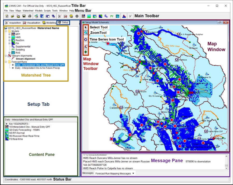
The Setup module is the grouping of commands for configuring a CWMS watershed. From the CWMS CAVI main window, click the Setup tab (Figure 1). A detailed discussion of common screen components is presented in Overview of the HEC-RTS Interface. The Setup tab (Figure 1) displays name of the watershed, the tree of the watershed, and the schematic of the watershed. The following sections provide an overview of the Setup module interface.
Menu Bar
The following is an overview of the Menu Bar (Figure 1) for the Setup module. The File, Tools, Window, and Help menus and their commands are common to all modules and are discussed in HEC-RTS Main Window.

| View | This menu allows you to zoom to all in the Map Window; display the units and time zone for the watershed in regards to plotting and tabulating; make adjustments to the Main Toolbar (Figure 1); display or not display the Status Bar and Message Pane (Figure 1); display or not display the module tabs; and save, restore and manage layouts. Available commands are: Zoom To All, Displayed Units, Displayed Time Zone, Toolbars, Messages, Status, Module Tabs, Save Layout, Restore Layout, and Layout Manager. |
| Maps | This menu is used to add and remove map layers (including Internet map layers); specify default map properties; display or not display an Internet map in the Map Window; set the display of the Map Window to either watershed coordinates or Internet coordinates (when Internet map is displayed); save the Map Window to a graphics file; and, print the Map Window. The available commands are: Map Layers, Default Map Properties, Add Internet Map, Display Map Coordinates, Save Map Image, and Print Map. |
| Watershed | From this menu, you can view the watershed properties; view a tree of the watershed files; manage stream reach alias; view a list of the streams in the watershed; upload or download a watershed; and, import or export stream alignment files (refer to Appendix J). The available commands are: Watershed Properties, Files, Stream Reach Alias Editor, List of Streams, Team, and Stream Alignment (refer to Appendix J). |
| Models | From this menu you can establish the program order; import model alternatives; specify model alternative keys; configure forecast runs; setup model linking; and, access the extract and post editors. Available commands are: Next Steps, Program Order, Import, Model Alternative Keys, Forecast Runs, Model Linking, Edit Extract, Edit Post, and commands related to models configured in the watershed (e.g., HMS). |
| Scripts | From this menu you can run, edit and schedule a script, and access the status of a script job. Available commands are: Editor, Schedule Script Job, Script Job Status, and Run. |
Map Window Tools
Map window tools allow you to access and configure elements within your watershed. The following are descriptions of tools in the Setup module . A description of the tools common to all modules is included in HEC-RTS Main Window.
![]() Select Tool – Use this tool to edit, rename, and delete elements. To access commands, select the Select Tool and right-click on an element. Commands are available from a shortcut menu.
Select Tool – Use this tool to edit, rename, and delete elements. To access commands, select the Select Tool and right-click on an element. Commands are available from a shortcut menu.
![]() Zoom Tool – Use this tool to enlarge specific locations in the map window. To enlarge a certain extent, left-click and drag tool over area; to zoom out, right-click.
Zoom Tool – Use this tool to enlarge specific locations in the map window. To enlarge a certain extent, left-click and drag tool over area; to zoom out, right-click.
![]() Time Series Icon Tool – Use this tool to create, delete, and edit Time Series Icons. See Time Series Icons for more detail on creating, deleting, renaming, and editing Time Series Icons.
Time Series Icon Tool – Use this tool to create, delete, and edit Time Series Icons. See Time Series Icons for more detail on creating, deleting, renaming, and editing Time Series Icons.
Stream Alignment Tools
These tools are available when a stream alignment is displayed in the Map Window of the Setup module . See Stream Alignment for more information regarding the stream alignment.
![]() Stream Alignment Tool – Use this tool to create, delete, and edit stream elements that make up the Stream Alignment. A stream alignment is a representation of the stream network in the watershed.
Stream Alignment Tool – Use this tool to create, delete, and edit stream elements that make up the Stream Alignment. A stream alignment is a representation of the stream network in the watershed.
![]() Stream Node Tool – Use this tool to create and edit stream nodes and junctions that make up a Stream Alignment. Stream nodes are the beginning and ending points for each stream element. Stream nodes are also points where stream elements meet (stream junctions).
Stream Node Tool – Use this tool to create and edit stream nodes and junctions that make up a Stream Alignment. Stream nodes are the beginning and ending points for each stream element. Stream nodes are also points where stream elements meet (stream junctions).