Download PDF
Download page GeoEFM: Application.
GeoEFM: Application
In addition to the data and structure obtained from the EFM project, GeoEFM applications typically begin with layers generated during the hydraulic modeling phase of the EFM process as well as other relevant data such as maps of land use, soils, and vegetation. These spatial data may be added to the GeoEFM project through the standard Add Data mechanisms available in ArcMap or ArcCatalog. Figure 9 shows a GeoEFM project that has been synchronized with an EFM application and has data added to the default “Layers” data frame (statistical results from EFM, which were subsequently used in hydraulic modeling to generate the corresponding layers, are also shown). Many of the layers shown in Figure 9 are included with the GeoEFM demonstration project, which is intended as a helpful starting point for new users (for more information, see section 5.9).

Figure 9. New GeoEFM project with connections to EFM statistical results.
Managing Spatial Layers (Managers)
The next step in a GeoEFM project is to organize the spatial layers per the structure obtained from the EFM project. Adhering to that structure is advantageous because it will ultimately facilitate the use of GIS functions for groups of spatial layers (e.g., apply a fish spawning criteria to depth grids for multiple water management scenarios) and enable comparisons of habitat areas for user selected flow regimes and relationships.
In GeoEFM, sets of “views” are built per the structure obtained from the EFM project. Each “view” is a data frame. There are three types of views: Standard, Combo, and Custom. Standard Views and Combo Views correspond directly to different parts of the EFM structure. In fact, placeholders for all possible Standard and Combo Views are made when the EFM and GeoEFM projects are synchronized.
Standard Views
Standard Views are used as workspace for pairings of flow regimes and relationships. When the EFM Manager – Standard Views menu option is selected, the Manage Standard Views interface activates and allows users to assign layers from the Source View to the Destination Standard View. Layers are assigned to the data frame associated with the Destination Standard View (Figure 10). If that data frame does not exist when layers are assigned, it will be created automatically by GeoEFM.
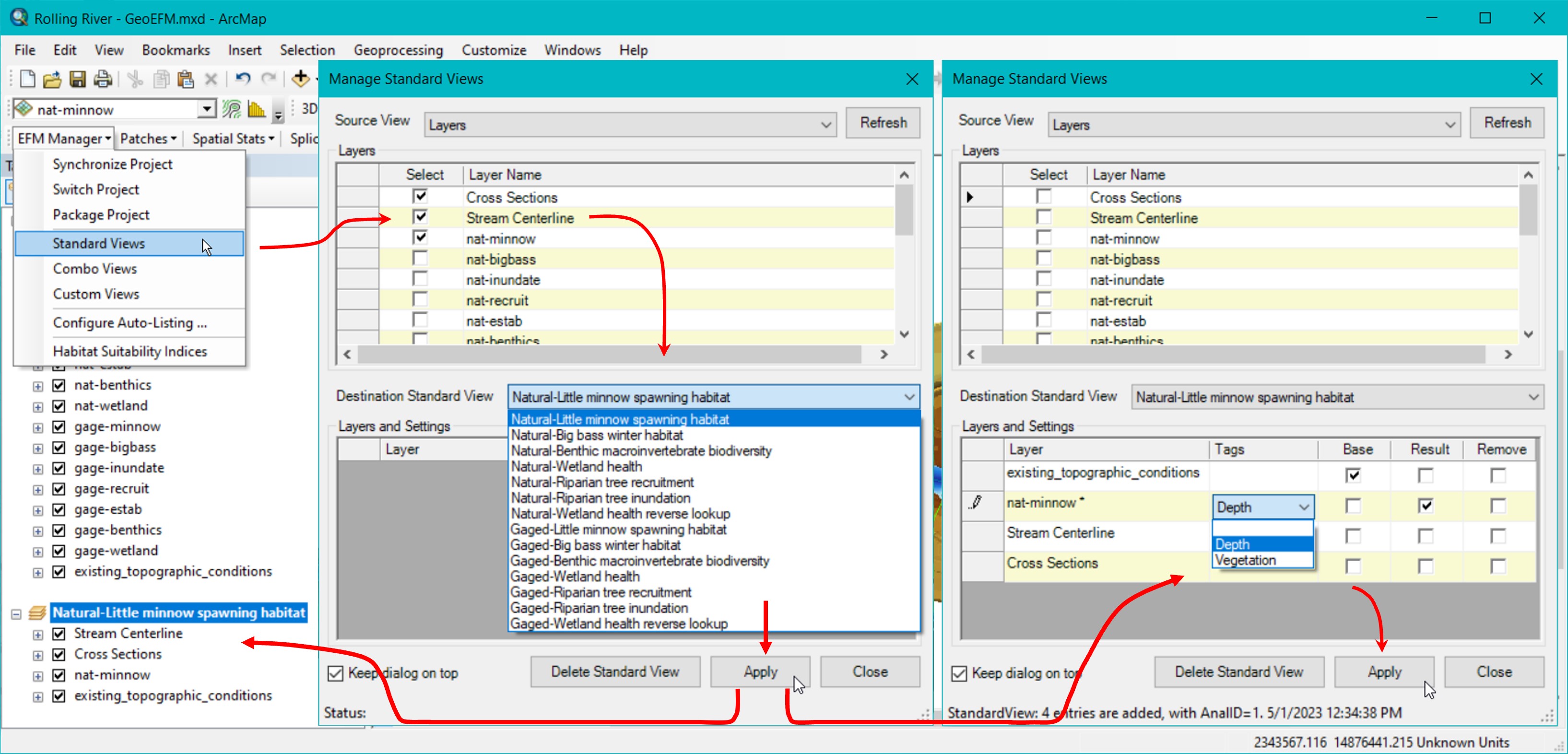
Figure 10. Creating and managing Standard Views in GeoEFM. Click sequence shows 1) open Manage Standard Views, 2) select Source View, 3) select desired layers, 4) select Destination Standard View, 5) click Apply to add selected layers, 6) specify whether added layers have Tags, are base maps, or are the result layer, and 7) click Apply to save those settings.
The Source View list includes all data frame names in the GeoEFM project. The Destination Standard View list includes all pairings of flow regime and relationships. The Source and Destination View selections are controlled by the user through dropdown text boxes. When layers are selected in the Source for addition to the Destination, the user must click the Apply button to actually add those layers. Clicking the Close button will deactivate the interface without assigning selected layers or saving any unapplied settings. Clicking the Delete Standard View button removes the data frame and all associated layers and settings for the Destination Standard View selected at the time of the delete command. Delete Standard View does not remove that selection from the list of Standard Views because the flow regime - relationship pairings are determined by the parent EFM application and must be managed at that level.
After the data frame for a Standard View is created, the user can specify Tags, Base, and Result settings for individual data layers. There is also a setting option for Remove, which, if selected when the Apply button is clicked, will remove that layer and its settings from the layer list and associated data frame.
In the current version of GeoEFM, Tags simply indicate that a relationship has a geographical requirement that could be used to further define which spatial areas meet all of the criteria needed for suitable habitat. For example, the Little minnow spawning habitat relationship has Tags called “Depth” and “Vegetation” (Figure 10). The ecological meaning of these tags is that, in addition to the statistical criteria considered by EFM, suitable spawning habitat for Little minnows is also characterized by a particular range of water depth (0 to 3 feet) and the presence of aquatic vegetation (USACE 2020). GeoEFM allows users to perform geographic queries based on layers associated with individual tags via the Batch Calculator. That is, based on the relationship, tag, and criteria specified by the user, GeoEFM will map areas that meet those criteria for multiple flow regimes per a single user command.
The Base setting allows users to designate layers as base maps. Bulky layers, in terms of memory requirements, are often stored in shared databases in order to limit memory use on individual computers. The EFM Manager – Package Project feature offers users the choice of whether or not to include layers designated as base maps when packaging GeoEFM applications.
The Result setting identifies the layer whose area meets all criteria for the relationship and flow regime being considered. There can be only one “results layer” per Standard View. The Tabulate feature discussed later herein queries results layers when computing and reporting total habitat areas for different flow regime - relationship pairings.
Combo Views
In EFM, combo relationships are used to detail how two or more relationships are grouped to represent a single ecosystem dynamic. In GeoEFM, combo relationships are treated much the same as regular relationships with one exception. As a tag indicates a geographical criteria for a relationship, the Tags setting is not relevant for combo relationships (geographical criteria are applied for each individual relationship) and has been replaced by the Combo setting (Figure 11).
The Combo setting allows users to identify layers as “Primary” or “Connected”. Only one layer per Combo View can be designated as primary; multiple layers can be designated as connected. Primary and connected layers are typically results layers for the regular relationships being grouped to represent the combo relationship. The primary layer serves as the starting point. Connected layers are then used to alter the primary layer via GIS functions such as clip or intersect to create a results layer for the combo relationship.
For example, the Riparian tree establishment combo relationship uses layers from both the Riparian tree recruitment and the Riparian tree inundation relationships. The recruitment layer is designated as primary and the inundation layer as connected, with the logic that to generate a layer of Riparian tree establishment areas start with areas suitable for seedlings to begin to grow (recruitment) and then remove areas where potential seedlings would be drowned (inundation).
All other buttons and settings in the Manage Combo Views interface behave as described above for their counterparts in the Standard Views manager.

Figure 11. Creating and managing Combo Views in GeoEFM.
Custom Views
Users can create Custom Views to perform comparisons of different water management scenarios, analyze data, or simply as workspace to do whatever GIS efforts are needed for the project. The only difference between a Custom View and a generic data frame in ArcMap is that Custom Views, while not part of the EFM structure, are part of the GeoEFM project and can therefore be managed through the EFM Manager – Package Project menu option and the View Finder feature, which is described later in this manual.
To create a Custom View, enter a name in the text box to the far right of the Custom View dropdown list and click the Add View button (Figure 12). The name, which must be unique in the project, will be added to the list of Custom Views. Any layers selected in the Source View will also be associated with the new Custom View at that time. Subsequent additions can be done by selecting those layers and clicking the Apply button.

Figure 12. Creating and managing Custom Views in GeoEFM.
Navigating GeoEFM Projects (View Finder)
The View Manager is a simple feature that allows users to switch between views associated with a GeoEFM project. This includes all Standard, Combo, and Custom Views. Functionally, this feature performs the same action as right clicking on a data frame and selecting the Activate menu option in ArcMap.
To use View Manager, select the desired view from the dropdown list on the GeoEFM toolbar and click the View Manager button, which has a globe icon and is located to the right of the dropdown list. Figure 13 shows the first step in the process of switching from the Gaged-Little minnow spawning habitat Standard View to Natural-Riparian tree establishment Combo View.

Figure 13. Using the View Finder in GeoEFM to toggle between different project views.