Download PDF
Download page Georgia Reservoir Tour.
Georgia Reservoir Tour
By Sara O’Connell, P.E.
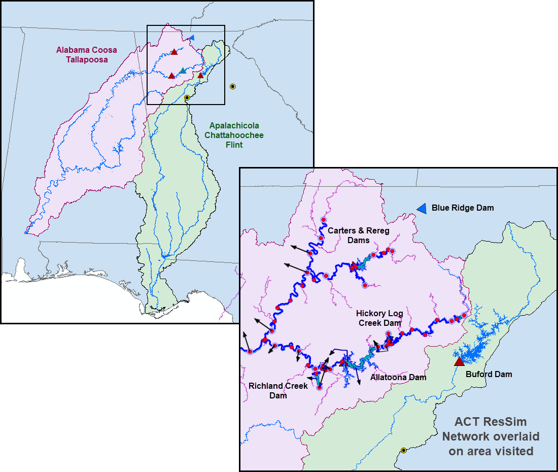
My brother was married in Athens, Georgia. Athens is a college town with a historic and active music scene (origin of R.E.M.)--just the place to host an artsy ceremony with a wedding dress-code listed as “creative.” As I pondered the appropriate “creative” attire to wear, it occurred to me that not only was this a chance for a little “Night Swimming” in Michael Stipe’s pool*, it was an ideal opportunity to visit some of the Georgia reservoirs that I have been modeling for the past decade (Figure 1).

Athens is in northern Georgia, not far from the Savannah River Basin and the upper end of the Alabama-Coosa-Tallapoosa (ACT) and the Apalachicola-Chattahoochee-Flint (ACF) Basins. After over a decade of personal history spent modeling reservoirs in these systems, I was thrilled to be heading to the region and able to reach out to Mobile District (SAM) about visiting. As to the wedding wardrobe dilemma, I gave up hope of blending in with the young music scene and chose something simple. A few decades past my college days, I can’t tell the difference between hip and horrid. So, after departing from the wedding celebrations in Athens, my partner and I headed to Ellijay, Georgia, past the horse farms and through the green spring pastures and forests of North Georgia, to stay in an Airbnb on a farm in this rural area.
My local contact was Ricky Wilson, plant manager of the ABC–that’s Allatoona, Buford, and Carters–Hydropower Project. While Allatoona and Carters are at the headwaters of the ACT Basin, Buford Dam (of the well-known Lake Lanier) is in the ACF Basin, close enough that we’d been able to make a stop there on our way from Athens. The three powerhouses have rated capacities of 82MW, 600MW, and 127MW, respectively, which in sum is more than half of Mobile District’s total generation capacity. The command center for managing all three of these projects is located at Carters Dam.
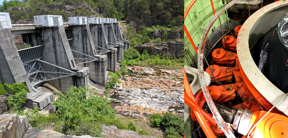
Ricky offered us a fantastic tour. At 400 ft, Carters is the tallest earthen dam in the eastern U.S. (although it is dwarfed by Oroville Dam’s 770 ft in the western U.S.). Carters has a storage capacity of 383 kilo acre feet but also has a reregulation pool just below, allowing water to be pumped back to the main reservoir at night and released through the powerplant to generate during the day. During the morning tour, we saw the generators, cooling towers, and turbines, and I had my first look at wicket gates (Figure 2). We learned about the normally scheduled maintenance and saw what needs to be inspected regularly - where a flange had rusted, where a bolt had loosened. We saw the control room and spoke to the operators there. I mentally compared the current releases at Buford Dam to the flows I’d seen at Buford the day before. I heard a lot of hydropower terms that I am unfamiliar with, which Ricky patiently explained. Despite wishing I’d studied hydropower before the tour, it was fascinating to see the kind of work that goes into operating and maintaining the facility and equipment and to be up close to these marvels of engineering!

After the tour, a hike, and a stop at the visitor center, we explored the area a little more. I was amused to pass the town of Talking Rock Creek, which I recognized as the name of a surprise element added to our ACT model years earlier. The HEC-ResSim modeling was initially based off the HEC-5 model which treated Carters and the reregulation pool as a unit and didn’t attempt to explicitly capture the pumpback. Though the pump feature was available in the HEC-ResSim software, we were struggling to replicate the pumpback operation from the reregulation pool to the main reservoir. Our eureka moment was when we realized that Talking Rock Creek was a small tributary whose flow had been lumped into the net inflow timeseries at Carters, but in reality enters the system downstream of the dam. This little tributary could introduce an additional few thousand cubic feet per second during high flow events, so it was very helpful to disaggregate that from the net inflow and add it directly to the reregulation pool, where it belonged.
We also took a short drive through the Chattahoochee National Forest to visit Blue Ridge Dam, a 16 MW project on the Toccoa River, which flows north into Tennessee. While this dam is not part of the ACT or ACF watersheds, it offered the opportunity to view a historic dam, built in 1931 and acquired by the Tennessee Valley Authority (TVA) in 1939. TVA, a product of Roosevelt’s New Deal, was envisioned as a corporation within the government with the mission to improve the quality of life in the Tennessee Valley through the integrated management of the natural resources. Today it is the nation’s largest government-owned power-provider, fully self-financed, no longer receiving appropriations, and operating based on income from power sales, which is reinvested.
The following day we had an evening flight out of Atlanta, and we managed to fit a just few more sites into our visit that morning. I sought out the newly constructed Hickory Log Creek Reservoir and happened to bump into the project manager, who permitted us a quick look at the dam. Hickory Log Creek Reservoir, which was built to help address needed water supply for the population growth in the area, is a pumped storage stream augmentation reservoir. It pumps water out of the Etowah River and into storage on the Hickory Log Creek tributary. The project was a joint effort between the Cobb County-Marietta Water Authority (which serves the Atlanta metro area) and the town of Canton, just upstream of Allatoona Lake. Operation of this reservoir is still in discussion, as the current demand is not quite as high as projected, and since no infrastructure exists to move the water to Atlanta, the only access available would require routing that water through Allatoona Reservoir, a practice the Corps is not currently authorized to conduct. It was fascinating to view the stair-step downstream face of this concrete dam and recall adding the project to our ACT model.
We stopped in the town of Canton for a taste of fresh Etowah River water before finally heading towards the airport, though we wound around Allatoona Lake a bit along the way. I wanted to take a look at the dam, but by the time we took a few wrong turns and wove around some of the 12,000 acre (270 shore mile) Allatoona Lake, it was an hour later than I wanted it to be. So we only briefly took in the sight of the 840 foot dam from the downstream side and spotted an osprey in flight. A pole hosted an osprey nest close to the banks, and I later found that the Corps and Georgia Power cooperated to construct several nesting poles in the area. Their efforts have attracted eight pairs of this threatened species to locations around Allatoona Lake. I could have gladly spent another week exploring, but short on time, we rushed off to the airport.
It was such a pleasure to visit these projects that in my prior experience had only existed in the digital world on my computer screen. I loved seeing the diversity of people recreating, enjoying some of the many services these reservoirs provide. The educational resources offered at the Carters visitor center include science and engineering displays, beehives (courtesy of an ERDC program that connects beekeepers with hive locations and encourages the propagation of pollinator communities and habitats), and an augmented reality sandbox (a model developed at UC Davis for playing with and visualizing watersheds). There are also the miles of gorgeous hiking trails and boating opportunities around the Corps reservoirs. While the low point of my trip was probably trying to get through the Atlanta airport, the highlight (aside from seeing my brother married and the generous dam tour) was definitely stopping by Buford Dam and seeing the vegetative maintenance workers - a whole herd of pygmy-dwarf goats (Figure 3) known as “The Chew Crew.” Can people resist the cuteness of these little lawn mowers? No! And neither could I!
Finally, I’d like to share a thought inspired by what the TVA sign reminds us with its statement, “BUILT FOR THE PEOPLE OF THE UNITED STATES OF AMERICA.” We Corps employees are civil servants, doing our best to care for our resources and nation. And our Corps projects offer so many benefits to us all.

*No night swimming occurred in Stipe’s pool, but it is fun to pretend.