Download PDF
Download page HEC's Role in Calculating Annual Flood Damages Reduced.
HEC's Role in Calculating Annual Flood Damages Reduced
By: Simon Evans, P.E., C.F.M.
One of USACE’s most visible and impactful responsibilities is to maintain and operate over 700 dams and 4000 miles of levees throughout the country. These projects are part of USACE’s Flood Risk Management mission to reduce the threat to life and property from riverine flooding. Year after year dams impound water in reservoirs to reduce uncontrolled flows downstream, and levees reduce the flood risk of communities and infrastructure in the floodplain. A dollar value of the benefit to the nation from these dam and levee projects is calculated every year and published in the Annual Flood Damages Report to Congress. HEC plays a vital role in the reporting of annual flood damages reduced through the creation and implementation of HEC software to calculate the flood damages reduced for each Corps project.
While the reporting of annual flood damages reduced for USACE dams and levees is not a new idea, the methodology of the calculations has been modernized in recent years. Historically, a set of stage versus damage curves were created for USACE dams and levees around the time of the project construction. These curves were associated to a local stream gage and represented the overall flood damages reduced for the given river reach at the specified river stage. The stage versus damage curves would be indexed to inflation, but otherwise left unchanged year after year.
Over time these generalized curves no longer accurately reflected the actual conditions in the watershed. For example, changes in land use from the 1960s to the present day may have resulted in new residential development in areas previously limited to agricultural use. Other areas might have lost the density of industrial use that was once present. The stage versus damages curves would not reflect these changes, and often the documentation on how the curves were created was sparse or nonexistent.
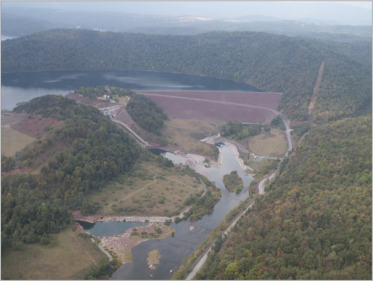
Over the last decade, USACE Districts across the country have developed Corps Water Management System (CWMS) models for watersheds that include Corps projects, as part of the CWMS National Implementation Program. These models provide the framework for water managers to develop real-time forecasts of hydrologic and hydraulic conditions in the watersheds, and to provide a decision support system for dam operations. For example, the Juniata River CWMS watershed model is used by the Baltimore District Water Management Section to support reservoir operations at Raystown Dam (Figure 1). Multiple HEC software applications are integrated into a CWMS watershed model through the CWMS Control and Visualization Interface (CAVI), including HEC-Metvue, HEC-HMS, HEC-ResSim, HEC-RAS, and HEC-FIA. More information about CWMS can be found here: https://www.hec.usace.army.mil/cwms/.
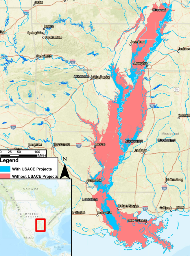
For a specific flood event, the USACE District can use the CWMS watershed model to simulate a what-if scenario to determine what the flood inundation and flood damages would be if the USACE dams and levees did not exist in the watershed. These theoretical damages can then be compared against a CWMS simulation of the actual event in order to estimate the flood damages reduced by the USACE projects. This approach to calculate flood damages reduced takes advantage of the latest spatial structure and agricultural inventories, inundation mapping, and reservoir operations to develop a more realistic picture of the benefit provided to the nation by USACE dam and levee projects. The use of CWMS watersheds to calculate flood damages reduced has replaced the legacy methodology as the preferred method to calculate flood damages reduced for USACE dam and levee projects. This approach can also illustrate the benefit provided by USACE projects through inundation maps that compare the with project inundation versus the hypothetical without project inundation (Figure 2).
HEC staff are involved in the national Flood Damages Reduced working group to provide support and guidance to USACE Districts as they transition to using CWMS to calculate flood damages reduced for their projects. The feedback received from the Flood Damages Reduced group has helped HEC add additional tools to HEC-FIA to refine and improve the flood damages reduced computations. HEC has a central role in how USACE calculates flood damages reduced by dam and levee projects through the creation of HEC software, and by providing support to USACE Districts as they perform the calculations.
Last Modified: 2023-06-07 16:08:10.358