Download PDF
Download page Background for Flood Warming System Planning Studies.
Background for Flood Warming System Planning Studies
Overview of Flood Warning Systems
What is it? A Flood Warning System (FWS) is an integrated package of data collection and transmission equipment, forecasting models, response plans and procedures, and human resources. Together these increase flood warning (lead) time. With increased lead time, public officials and citizens can take actions to reduce damage and to protect lives. A FWS is classified as a nonstructural damage reduction alternative: it will not reduce flood flows or flood stages, but it will reduce damage incurred due to a specified stage. A complete flood warning system includes components that are illustrated conceptually below.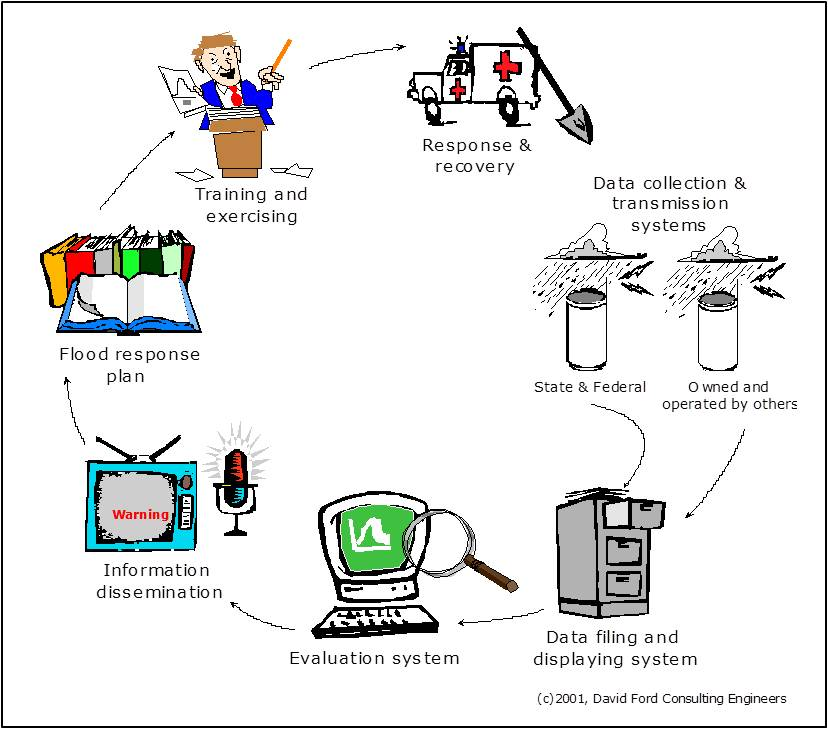
Flood warning begins with data collection and transmission. The instruments in the data collection and transmission system measure current rainfall depths, water levels, and other indices of watershed conditions. Rainfall commonly is measured in a FWS with a tipping-bucket rain gage. Such a gage records the clock time at which a small bucket of known volume within the gage fills and tips. From this time series, the rate of and cumulative depth of rainfall can be calculated. For water-level observation, a pressure transducer or shaft encoder is commonly used. The former measures the pressure at the bottom of the channel, from which the depth can be inferred. The latter measures the distance from a fixed reference point above the channel to the water surface; from this, the depth can be inferred.
The environmental condition measurements form the basis of flood-threat recognition. In the simplest case, the observed water level can be compared with a predetermined threshold. This threshold may be the elevation at which water will flow out of bank and damage property or threaten lives. If the level reaches the threshold, then a warning is issued.
The comparison of observations to thresholds may occur at the observation site or elsewhere. In the latter case, the data transmission components relay the observations to a central site - a base station at a flood warning center - for analysis. The data transmissions may use radio, microwave, dedicated or leased telephone lines, or satellite. The most common transmission type for local FWS in the United States is UHF or VHF radio broadcast using the ALERT standard. This standard was established by NWS and its cooperators (NOAA, 1997; NHWC, 2001). With an ALERT-based FWS, the transmitters send a signal for each "event". An event, in this case, is a water level rise or fall of a pre-selected distance (typically 0.1 foot) or a tip of the rain gage (about 0.04 inches of rainfall). The transmission is a forty-bit radio signal that identifies the sensor and includes the current rainfall depth or water-level reading in coded form. Transceivers (repeaters), situated on high ground with line-of-sight to gages and base stations, reconstitute and forward the signals, thus increasing the areal extent of the system. Equipment for ALERT systems is available commercially, off-the-shelf, or from various vendors.
The data transmitted from the sensors are received, encoded, managed, and analyzed at a central site. This site is equipped with a base station that includes an antenna and cabling; a modem, radio, or satellite receiver; a decoder - a microprocessor that converts the signal from the gages into digital data appropriate for filing or analyzing with a computer; and a dedicated computer with add-ons and peripheral devices.
The rainfall and streamflow data are managed at the flood warning center with base station software: database-management software that translates and stores data for subsequent analysis and reporting and visualization software that expedites examination of the data for threat detection. Commercial, off-the-shelf base station software systems are available. If the data are needed at more than a single site to ensure proper response, a data dissemination system redistributes the observations from the central site to other sites, using, for example, a local area network or a web site.
The evaluation system includes tools to display and inspect the incoming data to determine if a flood threat exists and tools to forecast occurrence of a future threat. For example, an evaluation system might be configured to compare observed water levels at the gage on Updah Creek to the level at which water is known to overflow and inundate structures nearby on Penny Lane. If the level reaches that threshold, then a warning is issued and appropriate actions are taken.
The evaluation system, at a minimum, includes (1) stage or rainfall depth thresholds that will be used to identify flood threats, and (2) the method by which the threat recognition plan is implemented. Alternatives for this threat recognition include (1) an operator-monitored procedure in which a human operator inspects the incoming data, compares the values with the thresholds identified in the threat recognition plan, and takes appropriate action, or (2) an automated procedure, in which software automates examination and comparison of the incoming data to rules of the threat recognition plan. If a threat exists, or is expected, an information dissemination system communicates an appropriate warning, first to emergency responders, and then to the public.
In many cases, threat recognition based upon observations alone will not provide adequate time to respond appropriately. In those cases, a forecasting system may extend the lead time by using mathematical models of watershed and channel behavior, along with the rainfall and water level observations, to predict future response of the watershed and channel. Alternatives to mathematical models for forecasting include (1) empirical forecasting models, which predict future stages based upon patterns inferred statistically from analysis of historical stages, historical rainfall depths, or both, and (2) conceptual models, which use a mathematical representation of underlying physical properties to forecast future stages, given observations of historical stage, historical rainfall, or both.
When a threat is recognized, either through observation or prediction, and warnings are issued, actions begin in earnest to protect lives and property. For efficiency, these actions should follow procedures spelled out in a flood response plan.
Authority and Procedural Guidance
USACE activities in flood warning are authorized by:
- The Flood Control Act of 1936.
- Section 206 of the Flood Control Act of 1960.
- Executive Order 11988.
- Section 73 of Public Law 93-251.
The following USACE guidance is particularly relevant to flood warning system planning and design:
- ER 1105-2-100 (USACE, 2000) provides guidance and describes procedures for all civil works planning studies.
- EM 1110-2-1417 (USACE, 1994) describes procedures for flood runoff analysis, which is critical to FWS planning.
- ETL 1110-2-540 (USACE, 1996) describes components of flood warning systems including preparedness programs and the general operation and maintenance procedures required for accurate flood warning.
Study Objectives
Hydrologic engineering studies play a critical role in providing information for planning, designing, implementing, and operating a flood warning system. Studies are required to:
- Identify vulnerable areas for which flood warning is an effective flood damage reduction alternative.
- Establish rainfall and water-level thresholds for threat recognition.
- Link the thresholds to the vulnerability assessment, so that those who should be notified can be identified.
- Identify locations for rainfall and water-level sensors.
- Develop and provide the tools for forecasting.
For every FWS in which the USACE plays a role, the first step is to assess the benefit of the FWS, so that the federal interest in implementation can be determined. For this federal interest to exist, the system's benefit must exceed its cost. The benefit of a flood warning system is due to actions taken or actions deferred as a result of the warnings issued. The benefit can be categorized as either tangible benefit, which can be assigned a monetary value, or intangible benefit, which cannot be assigned a monetary value but may be otherwise quantified or described (IWR, 1994). The FWS benefit may be categorized further as direct or indirect. Direct benefit accrues to floodplain occupants who are "protected" by the system. This benefit includes inundation-reduction benefit and emergency response and recovery cost avoided. Conversely, indirect benefits result from externalities: impacts outside the floodplain or impacts secondary to the response system's design goals. Assessment of the direct tangible benefit is the subject of this chapter.
Study Procedures
The guidance cited above directs planners to assess the FWS benefit, but it does not stipulate how this is to be done. A common approach is to use the so-called Day Curve (USACE, 1996), which is shown below.
The Day Curve was developed from empirical analysis of property in a floodplain, considering the value and spatial distribution of property and the likely response of property owners when warned. The Day Curve estimates damage reduction (as a percentage of total inundation damage) as a function of the warning (mitigation) time - the time available for citizens and emergency responders to protect lives and property. For example, the curve shows that if the warning time is zero hours, a FWS provides no direct tangible benefit. If the warning time is twelve hours, the curve predicts that the damage will decrease by 23 percent. The curve also suggests that no matter how great the warning time, the maximum possible reduction is about 35 percent of the total damage due to the flood. This is logical, as some property, including most structures, simply cannot be moved.
To use the Day Curve, the analyst must estimate the mitigation time attributable to the FWS. ETL 1110-2-540 (USACE, 1996) provides guidance for this. It defines first a maximum potential warning time; this is the time that passes between the first detectable or predictable precipitation and the time at which the stage exceeds the threshold for damage or threat to life at a critical location. The actual warning time, better known as mitigation time, is the maximum potential warning time less (1) the time required actually to detect and recognize the threat, (2) the time required to notify emergency responders and for those responder to make decisions about actions, and (3) the time required to notify the public. For example, if the maximum potential warning time is ten hours, and if six hours are required for detection, one hour required for emergency responder notification and decision making, and one hour required for public notification, then the actual mitigation time is only two hours. If the FWS reduces the detection time to four hours, the mitigation time increases to four hours.
The detection and notification times depend upon the design of the FWS, the equipment included, the efficiency of the response plans, and so on. The maximum potential warning time, on the other hand, depends on the characteristics of the watershed and storms that occur. A watershed model such as HEC-HMS will provide the information to estimate that. The case study that follows illustrates this.