The precipitation bias adjustment method can be used when interpolating a precipitation grid from gage measurements. It is typically used in mountainous regions where terrain between weather stations plays a significant role in the magnitude of precipitation, but it can be used any time the user wants to use a "bias" grid to adjust, or pattern, the distribution of precipitation in the interpolated grid cells. Often PRISM 30-year normal or monthly grids are used as the bias grid. Below are the computation steps performed by HEC-HMS when using the bias adjustment method.
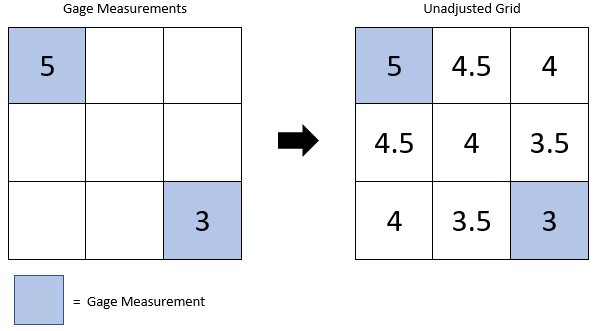
1. Compute the interpolated grid with no bias adjustment.
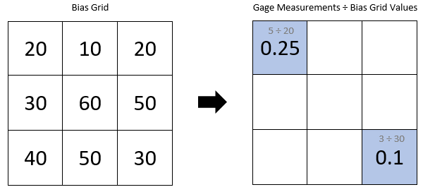
2. Divide each gage measurement by the value of the bias grid at the gage location.
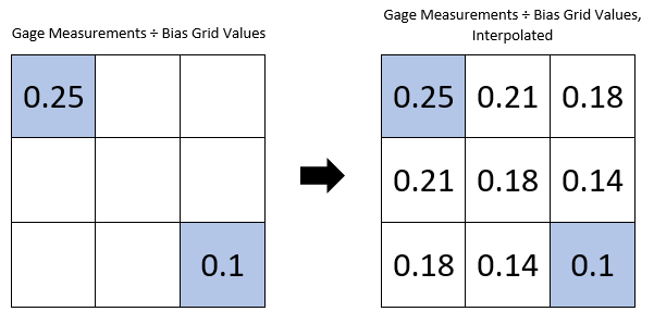
3. Compute an interpolated grid using the adjusted gage measurements.
4. Multiply the resulting grid by the bias grid.
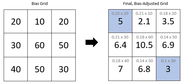
Notice how the gage measurements are retained in the final, bias-adjusted grid. However, the spatial distribution of interpolated grid values between the gage measurements is more similar to the bias grid than the original, unadjusted grid. The highest values in the original, unadjusted grid were in the upper left portion of the grid, and the lowest values were in the lower right portion of the grid. In the bias grid, the highest values are in the center and lower portion of the grid, and the lowest values are in the upper portion of the grid. In the final, bias-adjusted grid, the highest values are also in the center and lower part of the grid, and the lowest values are in the upper portion (ignoring the gage measurements). In this way, the measured values are retained, but the relative differences in magnitude between interpolated grid cells are similar to the bias grid.