Download PDF
Download page Task 2: Reservoir Volume Reduction Modeling with Outflow Curve Routing Method (Elevation-Storage-Area-Discharge).
Task 2: Reservoir Volume Reduction Modeling with Outflow Curve Routing Method (Elevation-Storage-Area-Discharge)
Software Version
HEC-HMS version 4.13 beta 6 was used to develop this tutorial. Version 4.13 beta 6 or newer is required.
Project Files
Download the initial model files here - Reservoir Volume Reduction_Outflow Curve Routing_Initial.zip
Overview
This example illustrates a method for developing a reservoir volume reduction application with the outflow curve routing method. This example focuses on using an existing HEC-HMS model and making appropriate modifications for a long-term reservoir volume reduction simulation. The HEC-HMS model must be reviewed to understand assumptions made when the model was developed. It is also important to look over the calibration results and assess whether the computed simulation does a good job replicating measured accumulated sediment volume. You may need to make additional adjustments based on your assessment. In this example, you will summarize the model parameters in the existing HEC-HMS model and choose appropriate input parameters for the Kanopolis lake simulation.
Overview
This example contains steps to develop a basic HEC-HMS reservoir volume reduction model from scratch using existing field data. You will summarize the model parameters from the given field data set and choose appropriate input parameters for the reservoir sedimentation simulation. Data used in the development of this model can be found in the Reservoir_Data.dss file in the HEC-HMS project's "data" folder.
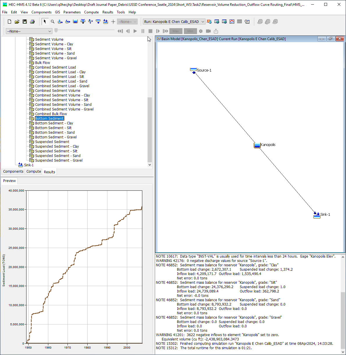
The following figure shows the starting point for the example. Notice the basin model is configured with a source element connected to a reservoir element, the reservoir is connected to a sink element.
Review the Model
- A initial HEC-HMS model of Kanopolis Lake has been prepared for you. Refer to the following HEC-HMS tutorials and guides listed below for more information on watershed delineation with HEC-HMS.
- Launch HEC-HMS and open the project by selecting File | Open | Browse. Navigate over to the project and select the HEC-HMS project named HMS_sediment.hms. Select the Basin Models folder. The Basin Model, Kanopolis_Chen_ESAD, was prepared as a case study to define model parameters to be used in the reservoir volume reduction simulation.
- Select the Kanopolis_Chen_ESAD Basin Model.
- Select the Kanopolis Reservoir element.
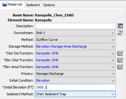
- On the Reservoir tab, change the Method to Outflow Curve.

- Populate the initial reservoir method, function, and parameters as shown below. Reservoir storage methods are described in the User's manual.
- Storage Method: Elevation-Storage-Area-Discharge (required this method for the reservoir volume reduction analysis)
- Stor-Dis Function: Kanopolis 1946 (generated based on measured data)
- Elev-Stor Function: Kanopolis 1946 (generated based on measured data)
- Elev-Area Function: Kanopolis 1946 (generated based on measured data)
- Primary: Storage-Discharge
- Initial Condition: Elevation
- Initial Elevation (FT): 1459.1
- Sediment Method: Chen Sediment Trap
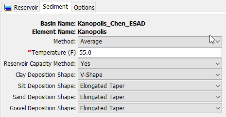
- On the Sediment tab, check the methods and input parameter as shown below.
- Run Kanopolis_Chen_EASD by selecting Run: Kanopolis E Chen Calib_ESAD from the simulation toolbar (shown below) and then clicking the compute button
 .
.
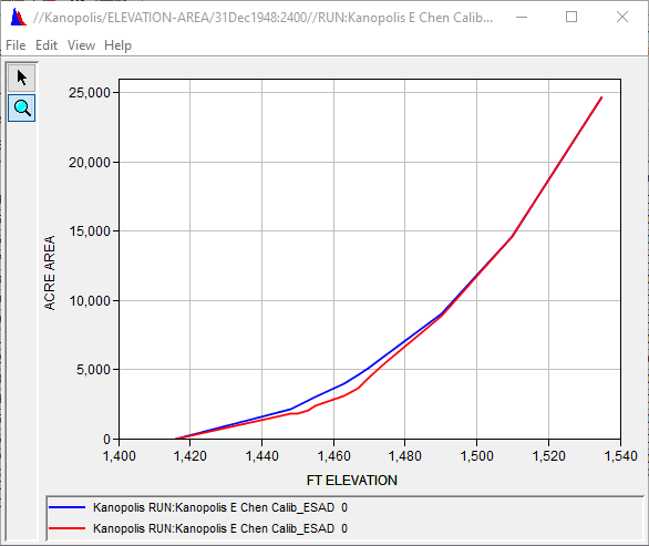
- Compare the ELEVATION-AREA curves between initial surveyed data and final simulation results.
- Go to this example's HEC-HMS project folder using File Explorer.
- Open the output DSS file (Kanopolis_E_Chen_Calib_ESAD.dss) using DSSVue.
- Select the two ELEVATION-AREA curves as shown below (these should be the first and last ELEVATION-AREA records). The D-part pathname shows the date the elevation-area information was updated (based on the amount of sediment into the reservoir).
1) //KANOPOLIS/ELEVATION-AREA/31DEC1948:2400//RUN:KANOPOLIS E CHEN CALIB_ESAD/
2) //KANOPOLIS/ELEVATION-AREA/19OCT2007:1200//RUN:KANOPOLIS E CHEN CALIB_ESAD/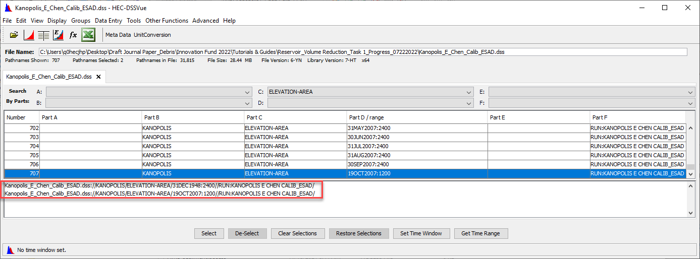
- Plot the graphs by clicking the plot button
 .
.
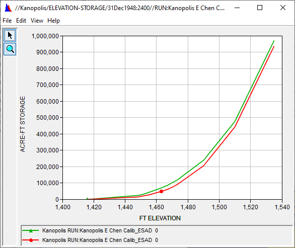
- Compare the ELEVATION-STORAGE curves between initial surveyed data and final simulation results.
- Select the two ELEVATION-STORAGE curves results as shown below (these should be the first and last ELEVATION-STORAGE records).
1) //KANOPOLIS/ELEVATION-STORAGE/31DEC1948:2400//RUN:KANOPOLIS E CHEN CALIB_ESAD/
2) //KANOPOLIS/ELEVATION-STORAGE/09OCT2007:1200//RUN:KANOPOLIS E CHEN CALIB_ESAD/
- Plot the graphs by clicking the plot button
- Select the two ELEVATION-STORAGE curves results as shown below (these should be the first and last ELEVATION-STORAGE records).
Question 1: How much was the surface area reduced at elevation 1467 ft during the period 31December1948 to 19October2007?
Area Difference at EL. 1467 ft: 933 ACRE and Percentage Difference: 20.34% reduced based on the original surface area.
Question 2: How much was the total storage volume reduced during the period 31December1948 to 19October2007?
Storage Volume Difference at EL. 1535 ft: 33,902 ACRE-FT and Percentage Difference: 3.5% reduced based on the original storage capacity.
Project Files