Download PDF
Download page Modeling Rain-on-Snow Events.
Modeling Rain-on-Snow Events
Introduction
Rain-on-snow events are a common occurrence on mountain slopes within the snow transition zone in the mountainous West. This is especially true for the rivers in the Sierra Nevada Mountains which typically experience their highest flow rates when warm winter storms interact with extensive snow cover (Kattelmann, 1997). The effects of rainfall on snowmelt can significantly increase flooding and associated damages. The U.S. Army Corps of Engineers (USACE) found that the major source of energy for snowmelt during rainfall is the convective transfer of sensible and latent heats from the atmosphere to the snow (USACE, 1956).
Snowmelt Simulation Capabilities within HEC-HMS
HEC-HMS is currently being modified to include three methods for accumulating and melting snow. These three methods range from being relatively simple with only a few required boundary conditions to intricate with numerous required meteorological inputs. All three methods include means to discriminate between precipitation falling as rain or snow, form a snowpack, melt the snowpack, reformulate the snowpack when temperatures drop below a defined threshold, and eventually melt the entire snowpack. Also, users have the ability to employ these methods at either a subbasin scale (i.e. lumped/banded) or within gridded (i.e. distributed) implementations.
Temperature Index
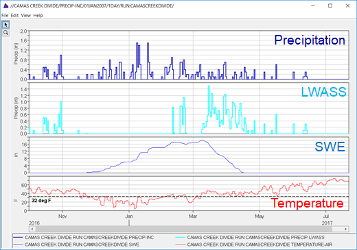
The simplest snowmelt/accumulation modeling approach within HEC-HMS, which has been available for several years, is the Temperature Index method. This method is based upon SNOW-17 (Anderson, 2006). Within this method, air temperature is used as a proxy for the energy available for heating or melting the snowpack. While this method is relatively simple, it is incredibly flexible, easily adjusted through model calibration, and has seen wide use throughout the U.S. to design and operate water supply and flood risk management infrastructure (USACE, 1998). Time series of precipitation, liquid water at the soil surface (LWASS), snow water equivalent (SWE), and temperature that is either used or generated by the Temperature Index method within HEC-HMS are shown in Figure 1.
Calibration Parameters and Tactics
Temperature Index snow parameters that were modified during model calibration along with an approach for each parameter are shown in the following table.
Method | Parameter | Calibration Approach |
|---|---|---|
Temperature Index Snow | PX Temperature | This parameter was varied to match the observed SWE accumulation. |
Base Temperature | This parameter was varied to match the observed SWE depletion. | |
Wet Meltrate | This parameter was varied to match the observed SWE depletion during rainfall. | |
Rain Rate Limit | This parameter was not varied during model calibration. | |
ATI-Meltrate Function | This parameter was varied to match the observed rate of SWE depletion during times when rainfall rates were less than the Rain Rate Limit. | |
ATI-Coldrate Function | This function was varied to match the observed timing of the start of SWE melt. | |
Snowpack Water Capacity | This value was varied to match the observed runoff generation from the melting snowpack. | |
Ground Melt | This value was set to zero and not varied during model calibration. |
Radiation-Derived Temperature Index (Hybrid)
While the Temperature Index method relies solely upon air temperature to estimate energy available to melt accumulated snow, the Radiation-derived Temperature Index (RTI) method utilizes additional factors to compute a proxy energy available for snowmelt. This representative energy is derived from a radiation balance computation that includes simple calculations of net shortwave and longwave radiation (Follum et al, 2015; Follum et al, 2019). Net shortwave radiation includes topographic, cloud cover, vegetation, and albedo effects while net longwave radiation includes contributions from the air, vegetation, cloud cover, and approximate snow temperature. Compared to the Temperature Index method, the RTI approach requires only a few additional meteorological inputs. While the RTI method has not been as widely used as the Temperature Index method within USACE, a recent publication evaluated the RTI method’s performance relative to the traditional Temperature Index model within the Willow Creek, Idaho watershed (Hamill et al, 2021).
Calibration Parameters and Tactics
Hybrid snow parameters that were modified during model calibration along with an approach for each parameter are shown in the following table.
Method | Parameter | Calibration Approach |
|---|---|---|
Hybrid Snow | Rain Threshold Air Temperature | This parameter was varied to match the observed SWE accumulation. |
Snow Threshold Air Temperature | This parameter was varied to match the observed SWE accumulation. | |
Base Temperature | This parameter was varied to match the observed timing and rate of SWE depletion. | |
Melt Factor | This parameter was varied to match the observed rate of SWE depletion. | |
Max Negative Melt Factor | This parameter was varied to match the observed timing of SWE depletion. | |
ATI Coefficient | This parameter was set to 0.98 and not varied during model calibration. | |
Wind Function | This parameter was set to 0.667 and not varied during model calibration. | |
Water Capacity | This value was varied to match the observed runoff generation from the melting snowpack. |
Energy Budget
The most complicated snowmelt/accumulation modeling approach being integrated within HEC-HMS utilizes a complete energy balance to simulate the growth, evolution, and melt of a snowpack. This method is based upon the Utah Energy Balance Snow Accumulation and Melt Model (Tarboton and Luce, 1997). This method has the ability to potentially outperform the two previously described methods when air temperature and/or net radiation are not the primary sources of energy available for snowmelt (USACE, 1998). For instance, both the Temperature Index and RTI methods do not implicitly include means for incorporating energy from turbulent heat transfer. However, the Energy Balance method suffers from the need for a large amount of highly accurate meteorologic inputs that are not readily available in most watersheds.
Calibration Parameters and Tactics
Energy Budget snow parameters that were modified during model calibration along with an approach for each parameter are shown in the following table.
Method | Parameter | Calibration Approach |
|---|---|---|
Energy Budget Snow | Rain Threshold Air Temperature | This parameter was varied to match the observed SWE accumulation. |
Snow Threshold Air Temperature | This parameter was varied to match the observed SWE accumulation. | |
New Snow Albedo | This parameter was varied to match the observed timing and rate of SWE depletion. | |
Min Snow Albedo | This parameter was varied to match the observed timing and rate of SWE depletion. | |
Albedo Refresh Depth | This parameter was varied to match the observed timing and rate of SWE depletion. | |
Albedo Decay Coefficient | This parameter was varied to match the observed timing and rate of SWE depletion. | |
Snow Thermal Conductivity | This parameter was varied to match the observed timing and rate of SWE depletion. | |
Liquid Water Retention Fraction | This value was varied to match the observed runoff generation from the melting snowpack. | |
Snow Hydraulic Conductivity | This value was varied to match the observed runoff generation from the melting snowpack. | |
Soil Depth for Energy Balance | This parameter was set to 0.1 meter and not varied during model calibration. |
Snowmelt Method Summary
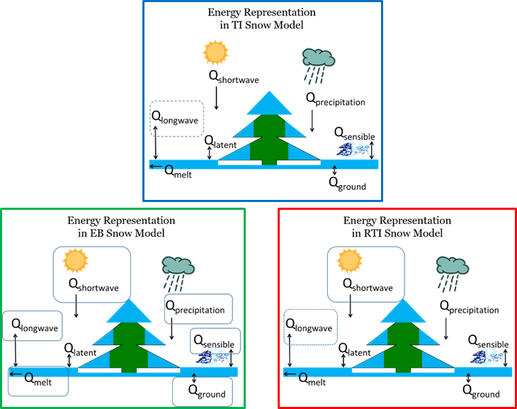
A schematic describing the various sources of energy that can go towards melting a snow pack or allowing it to accumulate volume is shown in Figure 2. The Temperature Index method incorporates the fewest sources of energy while the Energy Balance method incorporates the most.
Given the significance of rain-on-snow floods and the forthcoming snowmelt methods within HEC-HMS, a comprehensive evaluation of the current state-of-the-practice methods and techniques for simulating rain-on-snow processes was proposed. This evaluation is attempting to answer the following questions:
- Given recent advancements in snow hydrology, what is the best method to use?
- Do more complex snow modeling approaches offer improved accuracy for short/long time scales, small/large areas, etc?
Additionally, this evaluation aims to provide guidance to users regarding where to find and how to effectively use data within snowmelt applications. Finally, the amount of effort required for data preparation as well as computational time will be tracked and reported for each method.
Truckee River
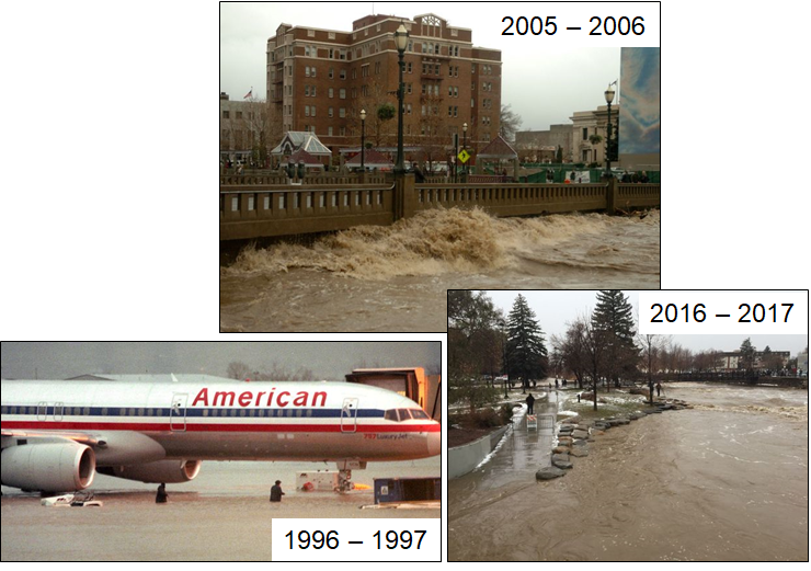
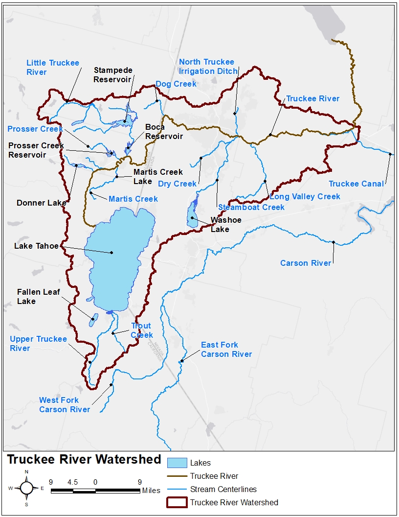
The Truckee River watershed was selected to demonstrate the benefits, drawbacks, and consequences of the aforementioned snowmelt methods. The Truckee River originates at Lake Tahoe in California and flows approximately 105 miles north and east into Nevada. Major population centers within the Truckee River watershed include the cities of Truckee, CA, Reno, NV, and Sparks, NV with a total population greater than 350,000 (as counted during the 2010 census). While the Truckee River provides a major source of water for its nearby inhabitants, the river is also prone to significant flooding. Substantial damage has occurred during large scale and widespread rain-on-snow flood events in 1950, 1955, 1996-1997, 2005-2006, and 2016-2017, as shown in Figure 3.
Numerous state and federal water supply and flood risk management projects have been constructed within this watershed (USACE, 1985). Several major federally-constructed projects include Martis Creek, Prosser, Stampede, and Boca dams, as shown in Figure 4.
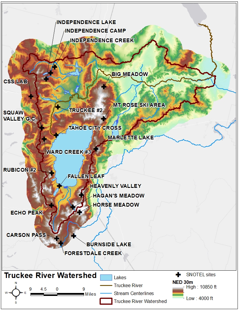
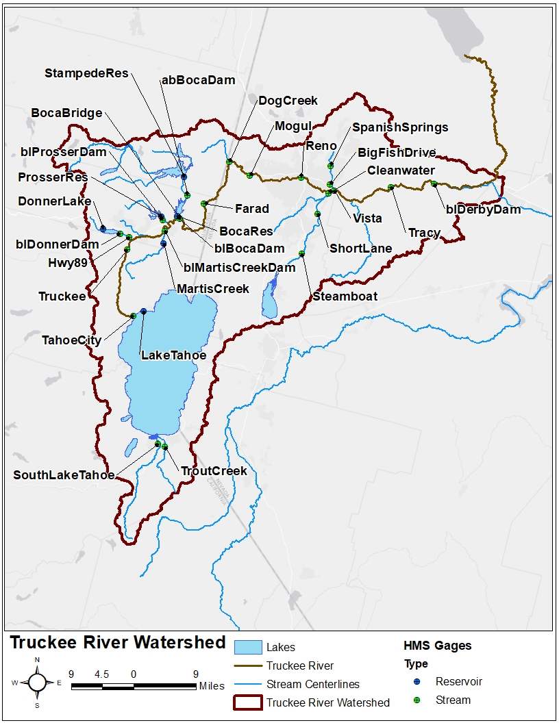
The Truckee River watershed offers an excellent opportunity to investigate snowmelt modeling techniques within a real-world watershed that contains an extremely large amount of meteorological, snow, river, and reservoir/lake observation stations. Approximately 50 active stream, reservoir, and/or lake gages are maintained by the U.S. Geological Survey (USGS) while approximately 20 Snow Telemetry (SNOTEL) stations are maintained by the Natural Resources Conservation Service (NRCS), as shown in Figure 5 and Figure 6.
Hydrologic Model
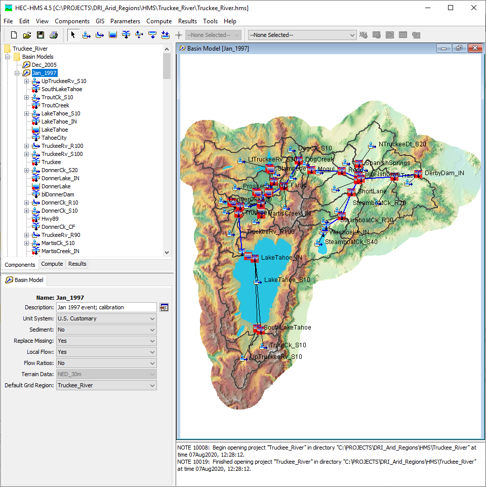
An HEC-HMS project was developed to evaluate the aforementioned snowmelt methods within the Truckee River watershed. This HEC-HMS project originated from the Truckee River Corps Water Management System (CWMS) implementation (USACE, 2015). Enhancements to the existing HEC-HMS project were made to facilitate improved accuracy as well as reduced computation times. The layout of this HEC-HMS project is shown in Figure 7.
Temperature Index - Point Calibration
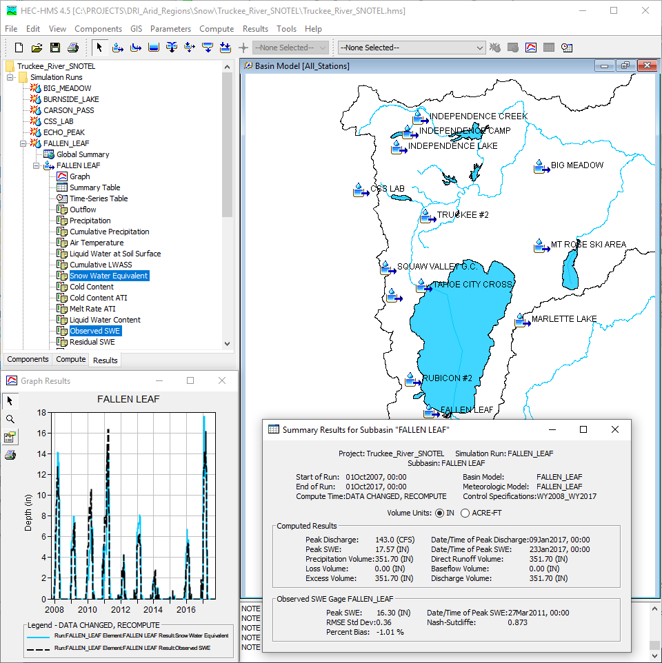
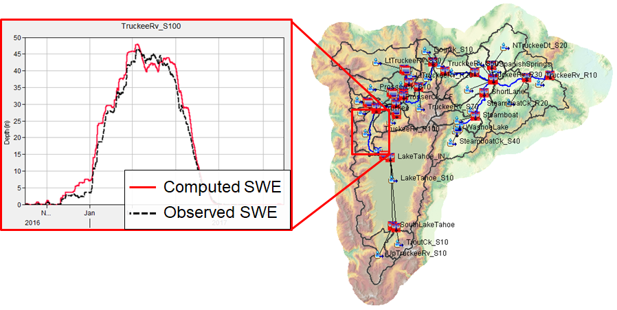
In order to derive appropriate Temperature Index parameters, the accumulation and melt of snow over 10 years was simulated at the 20+ SNOTEL stations within or surrounding the Truckee River watershed. SWE computed by HEC-HMS at each SNOTEL station was compared against observed data, as shown in Figure 8. Temperature Index parameters were varied in order to achieve adequate calibration using several statistical metrics.
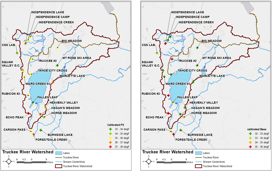
The calibrated Temperature Index parameters achieved during this process were found to vary throughout the modeling domain. For instance, the calibrated PX and Base temperatures varied by approximately 5 degrees, as shown in Figure 9.
Temperature Index - Distributed Calibration
Following the point calibration effort, the accumulation and melt of snow throughout water year (WY) 2017 was simulated throughout the Truckee River watershed. Subbasin-average SWE computed by HEC-HMS was compared against output from the National Operational Hydrologic Remote Sensing Center (NOHRSC) Snow Data Assimilation System (SNODAS) (NOHRSC, 2004), as shown in Figure 10. Temperature Index parameters were varied for each subbasin in order to achieve adequate calibration using several statistical metrics.
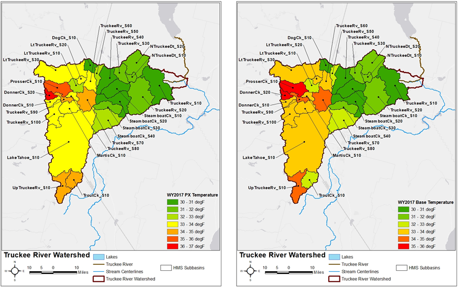
Similar to the point calibration effort, the distributed Temperature Index parameters achieved during this process were found to vary throughout the modeling domain. For instance, the calibrated PX and Base temperatures varied by approximately 7 degrees, as shown in Figure 11.
Precipitation-Runoff Calibration
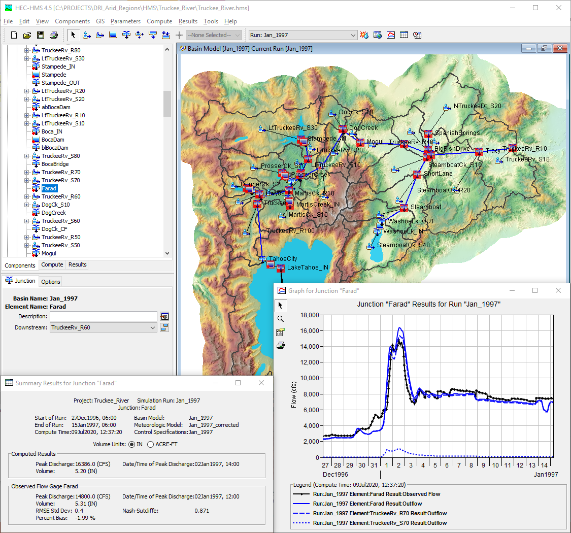
The conversion of precipitation to runoff was then simulated throughout the Truckee River watershed. Two large flood events occurring in January 1997 and December 2005 along with the entire WY2017 were simulated throughout the Truckee River watershed. Runoff and reservoir/lake pool elevations computed by HEC-HMS were compared against observed data obtained from the USGS, USACE, and U.S. Bureau of Reclamation, as shown in Figure 12.
Next Steps
The RTI and Energy Balance snowmelt methods are currently being parameterized, calibrated, and validated using the same observed data within and surrounding the Truckee River watershed. The same flood events (January 1997, December 2005, and WY2017) are also being simulated using the RTI and Energy Balance snowmelt methods. The results of these simulations will allow for a direct comparison of the benefits and drawbacks unique to each snowmelt/accumulation method. Model-derived outputs will be compared and notable differences will be identified, investigated, and described. Finally, recommendations for selecting a snowmelt/accumulation method will be made given typical study conditions, varying levels of observed data availability, accuracy, uncertainty considerations, schedule requirements, and available budget through the use of the aforementioned comparisons. Training materials will be developed for use within USACE training courses geared towards snowmelt/accumulation modeling. Additionally, HEC-HMS supporting materials (user’s manual, technical reference manual, and applications guide) will be developed and included within future software releases.
HEC-HMS Projects
The Temperature Index - Point Calibration HEC-HMS project can be downloaded here:
The Temperature Index - Distributed Calibration HEC-HMS project can be downloaded here:
References
Anderson, E. (2006). Snow Accumulation and Ablation Model - SNOW-17. Natural Resources Conservation Service.
Follum, M. L., Downer, C. W., Niemann, J. D., Roylance, S. M., & Vuyovich, C. M. (2015). A Radiation-Derived Temperature-Index Snow Routine for the GSSHA Hydrologic Model. Journal of Hydrology, 723-736.
Kattelmann, R. (1997). Very Warm Storms and Sierra Nevada Snowpacks. Proceedings of the Western Snow Conference 65, (pp. 125-129).
National Operational Hydrologic Remote Sensing Center. (2018, October). Snow Data Assimilation System (SNODAS) Data Products at NSIDC, Version 1. Retrieved from https://doi.org/10.7265/N5TB14TC.
Tarboton, D. G., & Luce, C. H. (1996). Utah Energy Balance Snow Accumulation and Melt Model (UEB). Logan, Utah: Utah State University.
U.S. Army Corps of Engineers. (1956). Summary Report of the Snow Investigations, Snow Hydrology. Portland, OR: North Pacific Division.
U.S. Army Corps of Engineers. (1985). Truckee River Basin Reservoirs, Water Control Manual. Sacramento, CA: Sacramento District.
U.S. Army Corps of Engineers. (1998). Runoff from Snowmelt, Engineer Manual 1110-2-1406. Washington, D.C.: USACE.
U.S. Army Corps of Engineers. (2015). Corps Water Management System, Final Report for the Truckee River Watershed. Sacramento, CA: Sacramento District.
