HEC-HMS version 4.11-beta.2 was used for this tutorial. In addition, you will also need HEC-DSSVue to perform calculations on the streamflow time series. HEC-DSSVue version 3.3.0 beta was used for this tutorial.
Many waterways are affected by regulation from dams and diversions. Streamflow records from these waterways reflect this regulation. Flow frequency analysis procedures, such as those codified in Bulletin 17C, involve fitting analytical distributions to streamflow records that are not appreciably altered by upstream regulation. Pre-regulation streamflow records are not typically long enough to use in a flow frequency analysis. Therefore, regulated streamflow records often need to be transformed to unregulated streamflow for flow frequency analyses.
To extract unregulated streamflow from a hydrologic model, a period of record simulation could be performed. However, this requires continuous meteorological forcing data, which may be difficult to obtain. In addition, a period of record simulation can be time-consuming to perform. Another approach is to develop a simple hydrologic routing model
In this tutorial, you will investigate two methods of transforming streamflow using hydrologic routing:
- Routing reservoir inflow and outflow separately
- Routing reservoir holdouts (reservoir outflow - reservoir inflow)
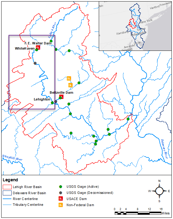
The Lehigh River is one of three major tributaries to the Delaware River. The Lehigh River includes approximately 1,300 square miles of land area in eastern Pennsylvania. Flows along the Lehigh are influenced by F. E. Walter Dam, located on the main stem Lehigh River, and Beltzville Dam, located on Pohopoco Creek. Both dams are operated by USACE Philadelphia District. F. E. Walter Dam was constructed in 1961 and was originally authorized for flood risk management, but recreation became a Congressionally authorized purpose in 1988. Beltzville Dam was constructed in 1972 and is authorized for flood risk management, water supply, and low flow augmentation. The Lehigh River supports recreational activities including whitewater rafting, boating, and fishing. Elevations in the Lehigh River basin range from approximately 2,000 ft in the northern headwaters to 200 ft near the confluence with the Delaware River.
In this tutorial, you will transform the regulated streamflow record at the USGS gage 01449000 Lehigh River at Lehighton, PA to unregulated streamflow. The tutorial will focus on the portion of the Lehigh River between F.E. Walter Dam and the Lehighton gage, shown in a purple box in the figure below. Streamflow at Lehighton is only affected by regulation from F.E. Walter Dam since the gage is located upstream of the confluence with Pohopoco Creek. Outflow from F.E. Walter Dam is measured at the USGS gage 01447800 Lehigh River below F.E. Walter Dam near White Haven, PA, which is located approximately 3,500 ft downstream of the dam.
