Figure 1 is a systems diagram of the watershed runoff process, at a scale that is consistent with the scale modeled well with the program. The processes illustrated begin with precipitation. The precipitation may be rainfall or could optionally include snowfall as well. In the simple conceptualization shown, the precipitation can fall on the watershed's vegetation, land surface, and water bodies such as streams and lakes.
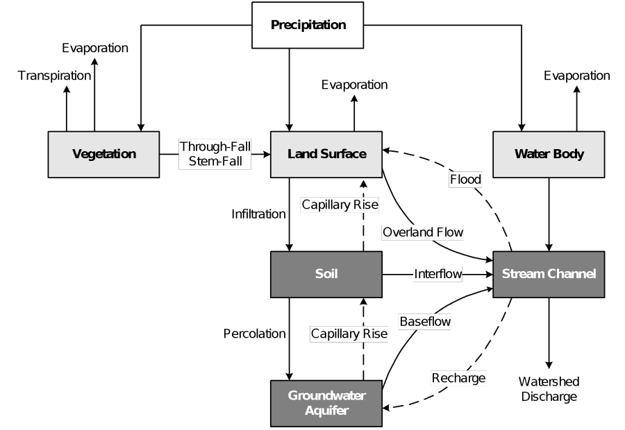
Figure 1.Systems diagram of the runoff process at local scale (after Ward, 1975).
In the natural hydrologic system, much of the water that falls as precipitation returns to the atmosphere through evaporation from vegetation, land surfaces, and water bodies and through transpiration from vegetation. During a storm event, this evaporation and transpiration is limited. The limitation occurs because the meteorologic conditions that result in precipitation often reduce evaporation nearly to zero by decreasing solar radiation and increasing relative humidity. Transpiration from vegetation may also be reduced during a storm because of decreased temperature. Finally, the short time window of a storm event does not allow the evaporation and transpiration processes to make a significant difference on the total water balance. However, evaporation and transpiration are almost always major components of the total water balance over long time windows, often returning a majority of the precipitation back to the atmosphere.
Some precipitation on vegetation falls between the leaves or runs down stems, branches, and trunks to the land surface, where it joins the precipitation that fell directly onto the surface. This is called through-fall and stem-flow, respectively. Once on the land surface, the water may pond, and depending upon the soil type, ground cover, antecedent moisture and other watershed properties, a portion may infiltrate. This infiltrated water is stored temporarily in the upper, partially saturated layers of soil. From there, it may rise to the surface again by capillary action. When enough water has infiltrated to create saturation zones, it begins to move vertically, and perhaps horizontally. The saturation point at which this occurs is called the field capacity. The presence of interflow (horizontal subsurface flow) is greatly enhanced by impeding layers such as clay. A saturated zone may develop above the impeding layer and horizontally just above it. The interflow eventually moves into the stream channel. Soil water above the field capacity also moves vertically as gravity drainage in a process called percolation. Percolation water eventually enters the groundwater aquifer beneath the watershed. Water in the aquifer moves slowly, but eventually, some returns to the channels as baseflow. Under some conditions, water in the stream channel may move to the groundwater aquifer as recharge.
Water that does not pond on the land surface or infiltrate into the soil moves by overland flow to a stream channel. The stream channel is the combination point for the overland flow, the precipitation that falls directly on water bodies in the watershed, and the interflow and baseflow. Thus, resultant streamflow is the total watershed outflow.