Download PDF
Download page Snowmelt Basic Concepts.
Snowmelt Basic Concepts
Snowpack/Snow Cover
The terms snowpack and snow cover are often used interchangeably but they do have slightly different meanings. The term snowpack is used when referring to the physical and mechanical properties of the snow on the ground. The term snow cover is used when referring to the snow accumulation on ground, and in particular, the areal extent of the snow-covered ground. This distinction will be respected for the most part. Both snowpack and snow cover refer to the total snow and ice on the ground, including both new snow and any existing un-melted snow and ice.
From the time of its deposition until melting, snow on the ground is a fascinating and unique material. Snow is a highly porous, sintered material made up of a continuous ice structure and a continuously connected pore space, forming together the snow microstructure. As the temperature of snow is almost always near its melting temperature, snow on the ground is in a continuous state of transformation, known as metamorphism.
At the melting temperature, liquid water may partially fill the pore space. In general, therefore, all three phases of water - ice, vapor, and liquid - can coexist in snow on the ground.
Due to the intermittent nature of precipitation, the action of wind and the continuously ongoing metamorphism of snow, distinct layers of snow build up the snowpack. However, in hydrologic applications, the snowpack is treated as a single layer and the properties of the snowpack must represent the conditions of the entire layer from the snow surface to the ground. This single layer representation is required by the practical limits of current hydrologic practice, and the currently available data on snow observed in the field. Generally, in practice, the distinct properties of individual layers of the snowpack are not known.
Snowpack
A laterally extensive accumulation of snow on the ground that persists through winter and melts in the spring and summer. AMS glossary
Snowpack
The total snow and ice on the ground, including both new snow and the previous snow and ice which have not melted. NSIDC glossary
Snowpack
The accumulation of snow at a given site and time; term to be preferably used in conjunction with the physical and mechanical properties of the snow on the ground. UNESCO glossary
Snow cover
In general, the accumulation of snow on the ground surface, and in particular, the areal extent of snow-covered ground (NSIDC, 2008); term to be preferably used in conjunction with the climatologic relevance of snow on the ground. UNESCO glossary
Seasonal Snow
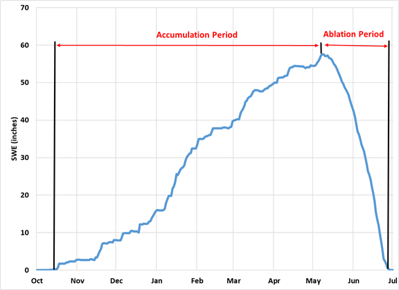
In almost all cases, the HEC-HMS snowmelt model is applied to seasonal snow. Seasonal snow is snow that accumulates during one season and does not last for more than one year. An example of seasonal snow is shown in Figure 1. The chart on this slide displays the Snow Water Equivalent (SWE) measured on Mount Alyeska in Alaska over the winter of 2000-01. Notice that the chart starts with a near monotonic increase in SWE up to the Annual Maximum SWE. This is the accumulation period. After the Annual Maximum SWE the ablation or melting period occurs. In many cases, the accumulation period is longer than the ablation period. In this case, the accumulation lasts for 7 months and the melt for 2 months. Other sites will vary in the timing and length of the accumulation and ablation periods. Some sites may have two or more accumulation periods and the SWE may drop to zero between the periods.
Temperature gradients and sub-freezing temperatures are more likely to exist in the snowpack during the accumulation period. Uniform temperatures throughout the snowpack at 32°F (0°C) are most likely to exist during the ablation period, especially during periods of continuous snowmelt.

Seasonal Snow Classification
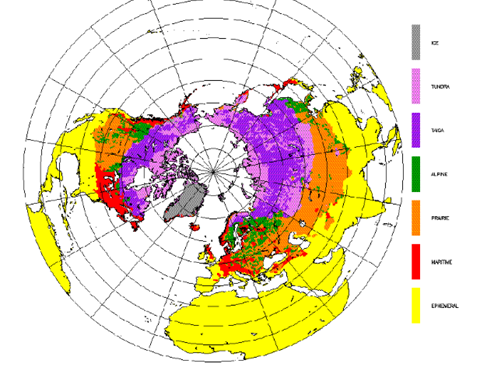
There is a tremendous amount of variability in seasonal snow. The range of seasonal snow characteristics has been catalogued and classified by Sturm et al (1995). They divided seasonal snow covers in to six classes: tundra, taiga, alpine, prairie, maritime, and ephemeral. They found it difficult to classify the snow cover of mountainous regions. Mountain snow covers have as their chief attribute a high degree of lateral or spatial variability. Wind turbulence over steep, complicated terrain and highly variable solar radiation distribution are the chief causes of this variability. So, the mountain snow class is used to flag regions of high snow variability. They found that these snow classes could be discriminated by a group of variables that they felt were relatively easy to measure. These variables are the winter average values of snow depth, air temperature, snow-ground interface temperature, and bulk density. The Table and Figure below describes the seasonal snow classifications and locations.
Class | Description | Depth (cm) | No. Layers |
|---|---|---|---|
Tundra | A thin, cold, wind-blown snow. Max. depth approx. 75 cm. Usually found above or north of tree line. Consists of a basal layer of depth hoar overlain by multiple wind slabs. | 10-75 | 0-6 |
Taiga | A thin to moderately deep low-density cold snow cover. Max. depth: 120 cm. Found in cold climates in forests where wind, initial snow density, and average winter air temperatures are all low. By late winter consists of 50% to 80% depth hoar covered by low-density new snow. | 30-120 | >15 |
Alpine | An intermediate to cold deep snow cover. Max depth approx. 250 cm. Often alternate thick and thin layers, some wind affected. Basal depth hoar common, as well as occasional wind crusts. Most new snowfalls are low density. Melt features occur but are generally insignificant. | 75-250 | >15 |
Maritime | A warm deep snow cover. Max depth can be in excess of 300 cm. Melt features (ice layers, percolation columns) very common. Coarse grained snow due to wetting ubiquitous. Basal Melting common. | 75-500 | >15 |
Ephemeral | A thin extremely warm snow cover. Ranges from 0 to 50 cm. Shortly after it is deposited, it begins melting, with basal melting common. Melt features common. Often consists of a single snowfall, which melts away, then a new snow cover reforms at the next snowfall. | 0-50 | 1-3 |
Prairie | A thin, except in drifts, moderately cold snow cover with substantial wind drifting. Max. depth approx. 1 m. Wind slabs and drifts common. | 0-50 | <5 |
Mountain | A highly variable snow cover, depending on the solar radiation effects and local wind patterns. Usually deeper than associated type of snow cover from adjacent low-lands. | Variable |
Basal: base (bottom) of snowpack
Hoar: Crystals that form in the snowpack after deposition. Common feature of Arctic snow
Melt Features: Evidence that melting has occurred; Could include an ice layer, percolation column, etc.
Wind slab: Both wind crusts and wind slabs are layers of small, broken or abraded, closely packed and well-sintered particles.

Snow Metamorphism
A snowpack is not static. The ice crystals and grains that comprise the snowpack are constantly evolving and changing throughout the winter season. This process is called snow metamorphism. There are two major processes of snow metamorphism that can occur. The first results from the general tendency of ice crystals to change their form to a more spherical shape. The rate of this metamorphism depends on the temperature of the snowpack. The closer the pack temperature is to 0°C (32°F) the faster metamorphism will occur. It proceeds relatively rapidly when the snowpack is melting. The second process of snowpack metamorphism is driven by vertical temperature gradients in the snowpack. The temperature gradient creates a vapor gradient which effectively moves water molecules between ice crystals by vapor transport. A strong temperature gradient through the snowpack (>10°C m-1) may result in the formation of new, relatively large, ice crystals within the snowpack termed depth hoar. This second form of metamorphism is common in the arctic but it can occur anywhere the difference between cold air temperatures and relatively warm ground temperatures are large and long lasting.
The first process of metamorphism occurs in all snowpacks. Its beginnings lay in the incredible variety of ice crystal shapes deposited on a snowpack. Something most crystal shapes share in common on reaching the snowpack is large surface-area-to-volume ratios. These large ratios are created during the rapid crystal growth that occurs in the atmosphere when snow crystals form. When the ice crystals are incorporated into the snowpack they no longer grow and tend towards their spherical equilibrium form. Snow metamorphism describes the change in the snow crystals and grains to less angular, more rounded forms with time. This type of metamorphism causes a gradual increase in the snowpack density, a reduction in the surface reflection of sunlight (described by the surface albedo) and changes other snowpack properties with time. Metamorphism occurs quickly when the snowpack is melting. This rapid metamorphism causes the surface albedo to decline relatively rapidly. The decline in albedo increases the shortwave radiation (sunlight) that can be absorbed by the snowpack and can increase the rate of snowmelt.
Hydrologic snowmelt models generally do not model snow metamorphism directly. Some approaches do model the changes in the snowpack density and albedo that result from metamorphism, as will be shown later.
Snow Phase Change
Phase change describes the transition between ice and liquid water, between ice and water vapor, and between liquid water and water vapor. Adding heat to snow causes the snow to become warmer until it reaches the ice/water equilibrium temperature, 0°C (32°F). (This is the value for fresh water under the normal range of atmospheric pressure.) The relationship between the amount of heat added (or removed) per unit volume of snow and rate of temperature increase (or decrease) is determined by the snow density and the specific heat of ice. Once the temperature of snow reaches the ice/water equilibrium temperature further addition of heat will not change the snow temperature but will cause the snow to melt, to change phase to liquid water. The relationship between the amount of heat added and the amount of liquid water created is determined by the latent heat of fusion of water.
The transfer of water molecules directly from the ice crystals to water vapor occurs by sublimation. Sublimation can occur over the entire temperature range at which snow exists. Sublimation removes heat from the snowpack to provide the ice molecules enough energy to escape from the snow ice crystal surface. Sublimation cools the snowpack. The relationship between the amount of ice removed by sublimation and the amount of heat removed defines the latent heat of sublimation of ice. The transfer of water from the vapor state to the snowpack occurs by condensation. Condensation adds heat to the snowpack to remove the energy of the water vapor molecules so they can join the liquid water or ice crystals that form the snowpack. Condensation warms the snowpack.
The transfer of water molecules between the snow surface and the atmosphere is one of the several modes of heat transfer between snow and the atmosphere. (The four major heat transfer modes being sensible heat transfer, latent heat transfer (evaporation and condensation), long wave radiation, and short-wave radiation.) Overall, the transfer of water is driven by the difference between the amount of water vapor per unit volume contained in a saturated vapor layer immediately above the snow surface and the amount of water vapor per unit volume contained in the atmosphere above. The actual rate of sublimation and condensation is controlled by the mass transfer ability of the meteorological boundary layer above the snow surface (as will be discussed below).