Download PDF
Download page v.4.8.0 Release Notes.
v.4.8.0 Release Notes
Beta released:
Final release:
New Features
Build Walls/Burn Streams
Building walls and burning streams can now be achieved entirely in HEC-HMS with the Terrain Reconditioning tool located within the GIS menu. This tool is very similar to the Build Walls and DEM Reconditioning tools that are available in HEC-GeoHMS.
The first step of terrain reconditioning involves building walls. The user can input shapefile boundary data that is used to specify where the cell elevations should be raised in the base terrain dataset. This is particularly useful if the user wants the HEC-HMS subbasin delineations to exactly match existing datasets such as subbasin boundaries used in prior studies or the hydrologic units found within the USGS's Watershed Boundary Dataset (WBD).
The second step of terrain reconditioning involves burning streams to force a stream network onto a terrain. This is often desirable when the base terrain dataset does not sufficiently capture channel definition within a watershed. Similar to the build walls step, the user can input a stream shapefile to specify where and how much to lower cell elevations in the terrain. A sharp drop height can be entered to abruptly lower a single line of stream cell elevations and/or a smooth drop height and buffer can be entered to gradually lower neighboring cell elevations so that there is a seamless transition from the center of the stream to the overbank.
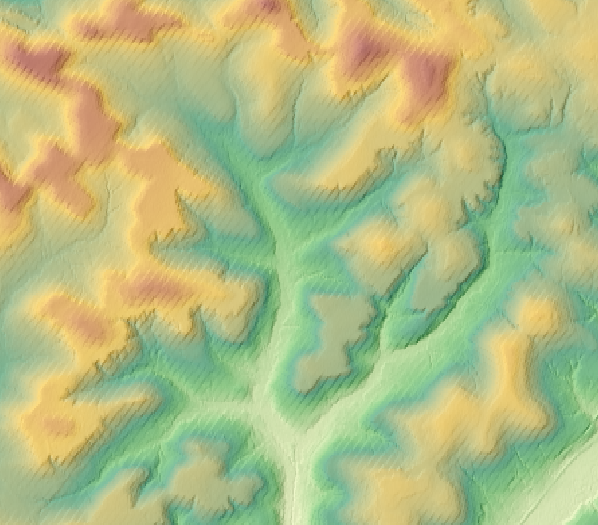
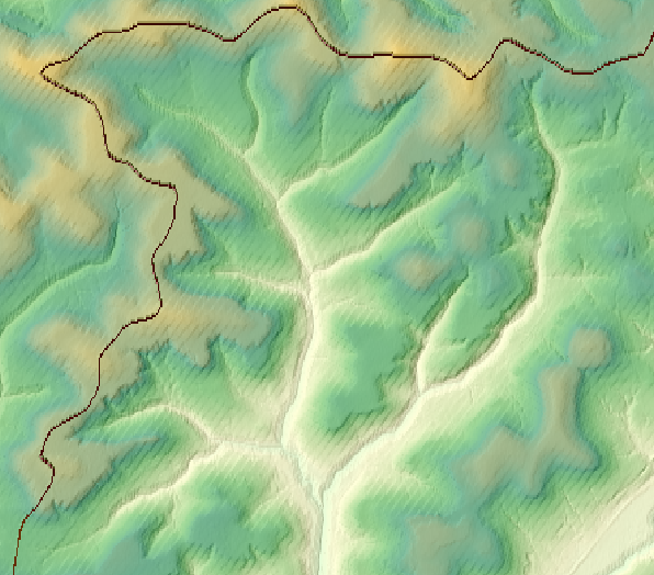
The below figures demonstrates a comparison of a base terrain dataset (below left) and a HEC-HMS reconditioned dataset with exaggerated, sharp walls and a smoothly burned channel (below right).
For more, see GIS Menu: Terrain Reconditioning.
The terrain reconditioning tool was implemented as a part of ongoing GIS work. Funding sources include the CWMS National Implementation Program. Initial code implementation and documentation were done by Josh Willis and Thomas Brauer. Testing was done by Josh Willis, Thomas Brauer, and Matt Fleming.
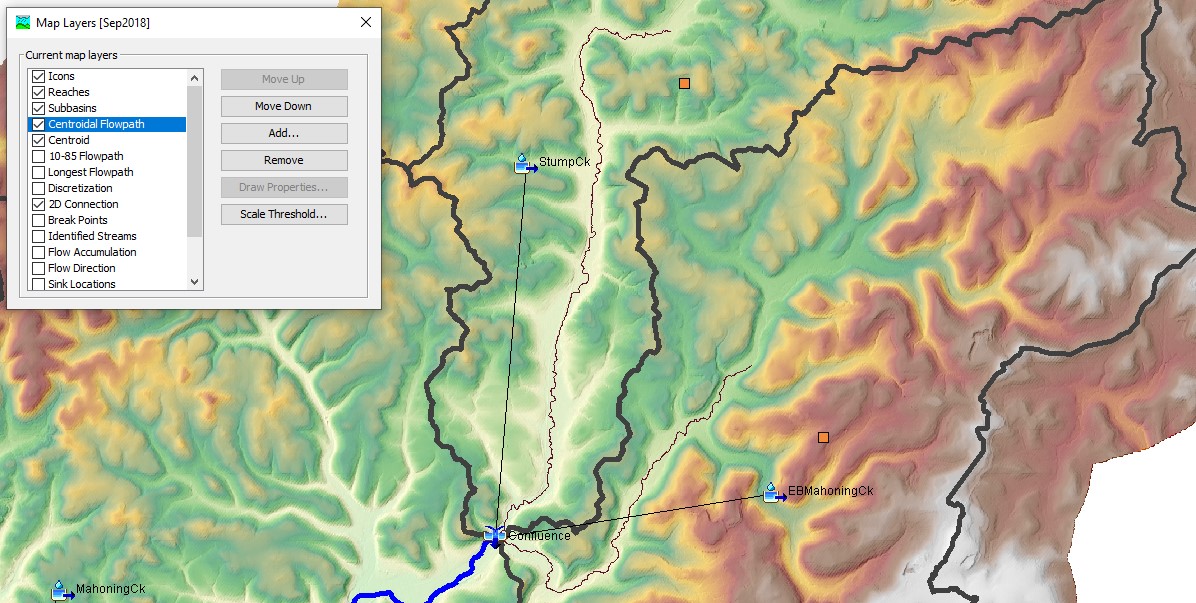
Subbasin Characteristics Layer Display and Export
After a subbasin characteristics compute is complete, the longest flowpath, centroidal flowpath, 10-85 flowpath, and subbasin centroid layers are saved to the basin model's sqlite file and automatically added to the map layers for viewing in Basin Model Map. The layers can optionally be exported to shapefile using GIS | Export Layer.
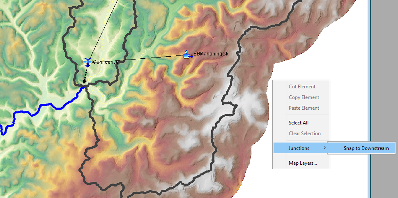
Junctions "Snap to Downstream" and Export
A new "Snap to Downstream" tool can be accessed by right clicking in the Basin Model Map. If junction elements have a reach as a downstream connection, this tool will snap them to the nearest end of the reach. Additionally, junctions can now be exported to shapefile via GIS | Export Layer.
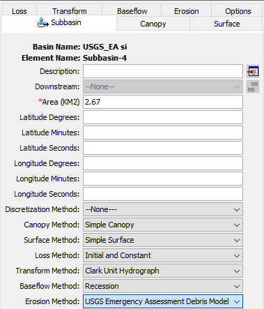
USGS Emergency Assessment Debris Model
The USGS Emergency Assessment debris yield model (Garter, Cannon, and Santi, 2014) was added to the erosion method. To predict volume of debris yield due to debris flows within two years of a fire. The USGS Emergency Assessment debris model can calculate debris yield volume based on three input parameters (peak 15-minute rainfall intensity, watershed area burned at moderate and high severity, and relief). The below figure shows the USGS Emergency Assessment Debris Method has been included in the list of Erosion Methods for a subbasin element.
The USGS Emergency Assessment debris yield method was funded by the USACE Arid Regions work unit within the Flood and Coastal Systems Research and Development program. The initial code implementation was done by Jay Pak with testing by Jay Pak.
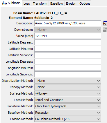
Los Angeles Debris Method EQ 2-5
The Los Angeles District Debris Method EQ 2-5 (Gatwood et al., 2000) was added to the erosion method. The equation used by this method was developed from statistical analysis of data from areas between 3.0 mi2 and 200.0 mi2 square miles. This method may also be used for drainage areas less than 3 mi2 if peak flow data available. The Los Angeles District Debris Method EQ 2-5 can calculate debris yield volume based on four input parameters (peak runoff, drainage area, relief ratio, and fire factor). The Los Angeles District Debris Method EQ 2-5 works best in arid or semi arid regions of Southern California where it was developed. The below figure shows the Los Angeles District Debris Method EQ 2-5 has been included in the list of Erosion Methods for a subbasin element.
The Los Angeles District Debris Method EQ 2-5 was funded by the USACE Arid Regions work unit within the Flood and Coastal Systems Research and Development program. The initial code implementation was done by Jay Pak with testing by Jay Pak.
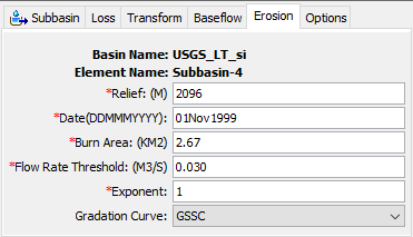
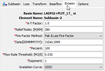
Flow Rate Threshold for Debris Yield Methods
The flow rate threshold option was added to four of the HEC-HMS debris yield methods. The threshold was added to divide storm events when simulating continuous hydrologic conditions that include both dry and wet periods. A debris flow event starts when the direct runoff is above the flow rate threshold. The event ends when direct runoff falls below the threshold. The below figure shows the Flow Rate Threshold value has been included in the subbasin element's Erosion tab.
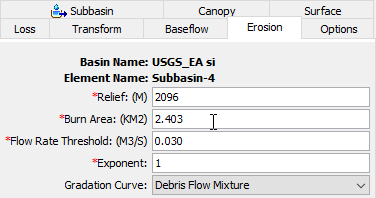
The Flow Rate Threshold feature was funded by the USACE Arid Regions work unit within the Flood and Coastal Systems Research and Development program. The initial code implementation was done by Jay Pak and Paul Ely with testing by Jay Pak.
Unregulated Outputs
The ability to produce "unregulated" outputs (e.g. flow, stage, velocity, etc) has been added to HEC-HMS. Downstream of regulating structures (reservoirs and/or diversion elements), outputs are considered to be "regulated". However, unregulated outputs are commonly required for use within flood risk management studies and forecasting applications, amongst others. For instance, unregulated outputs can be compared against regulated outputs to estimate benefits/damages due to regulation. Also, when fitting a Log Pearson Type III analytical probability distribution to an annual maximum series of observed peak streamflow using Bulletin 17C procedures (England, et al., 2019), an annual maximum series of unregulated peak flow is recommended for use. Removing regulation effects to produce a homogenous, independent, and identically distributed sample prior to fitting an analytical distribution helps to ensure that inferences of quantile information (e.g. flow) at rare annual exceedance probabilities (i.e. less than 1/100) are valid and statistically sound. In the following image, regulated flow (blue line) and unregulated flow (red line) is compared against observed flow (black line) at a location within the West Branch Susquehanna River for a flood event in September 2018.

Initial code implementation was done by Paul Ely and Mike Bartles. Documentation and testing were done by Mike Bartles.
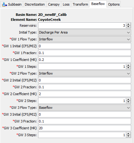
New Linear Reservoir Baseflow Option when Paired with the 2D Diffusion Wave Transform Method
As shown below, a new option was added to the Linear Reservoir Baseflow method that allows the user to set the groundwater layer to Interflow or Baseflow. By default, the Baseflow option is selected. The Interflow option can only be chosen when the transform method is set to use the 2D Diffusion Wave method. The interflow option is an initial attempt to integrated surface-subsurface flow for 2D modeling. If the user chooses Baseflow, then the routed subsurface water is added to the total flow at the outlet(s) of the subbasin. If the user chooses Interflow, then the subsurface water is only routed within the 2D cell, where the infiltration happened. The routed interflow is added to the cell's surface flow and routed on the 2D surface to downstream grid cells (where it can be infiltrated again). We found this approach could provide adequate results at the subbasin outlet, and at interior cells within the 2D area. See the example application.
2D Sediment Transport
The two-dimensional (2D) sediment transport computational engine that was originally developed for use within HEC-RAS has been made available for use within HEC-HMS as a transform method. The 2D Sediment Transport method simulates unsteady two-dimensional horizontal (2D) sediment transport, and bed change, sorting, and layering. Sediment transport is computed with a non-equilibrium total-load formulation. The total-load transport equation is solved with implicit Finite-Volume methods on the same unstructured polygonal mesh as the flow solver. Sediment transport is coupled to the flow model at the time step level. One powerful feature of the 2D flow solvers is that they use the subgrid topographic variations directly into the model thus improving the accuracy of the solution and permitting the use of relatively coarse meshes resulting in reduced computational times. The sediment transport model is designed to work within the subgrid framework of the flow model, and computes subgrid erosion and deposition rates, bed elevations, gradations, and bed layering.
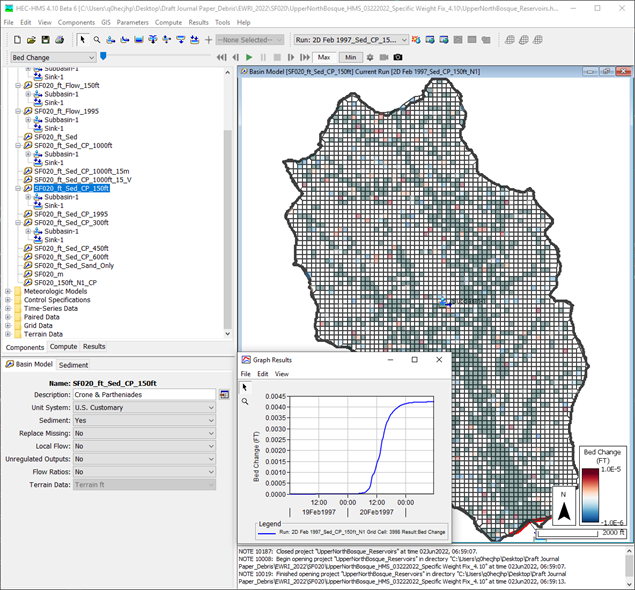
The 2D Sediment Transport capability was funded by the USACE Flood and Coastal R&D program. The project was led by Jay Pak and Michael Bartles. Initial code implementation was done by Michael Bartles, Alex Sanchez, and Paul Ely, Contractor. Documentation was done by Jay Pak. Testing was done by Jay Pak and Matthew Fleming.
Bugs Fixed
The following bugs were present in previous versions and have been fixed within version 4.8.
Sample project extract from Help | Install Sample Projects
Fixed the issue where Help | Install Sample Projects does not install the sample project to the chosen directory. The logic has been updated so that the program successfully extract 'samples.zip' to the specified directory.
Import from projection file in Gridded Data Import Wizard
When adding a target projection from the browse prj button in the Gridded Data Import Wizard, the string returned from the selected prj file was simply the path to the prj file. This has been corrected so that the contents are read from the prj file and displayed as the target well-known-text projection string.
Grid cell file validation logic
In some cases, a failure to generate structured discretization grid cells, or error 40064, would occur because of bad grid cell file validation logic. The validation logic has been updated.
Out of memory issue when Store gridded state variable results program option is turned on
The traditional store gridded state variable results program setting caused problems when attempting to run with new Structured/Unstructured discretizations. Logic has been updated so that the program option will only work when a traditional mod Clark grid cell file is used. The new spatial results feature in HEC-HMS can be used to store and visualize spatial results.
Reach characteristics compute failure when reach name is null
If a reach name was null in the basin SQLite file, reach characteristics would fail to calculate for all reaches. Logic has been updated so that the reach characteristics compute proceeds if there is a reach named null.
Subbasin can-merge failure with self-intersecting polygons
Fixed issue with subbasin merge when a delineated subbasin intersects another delineated subbasin. Previously the can-merge logic only tested if subbasins touched. The updated logic allows a merge if the subbasins touch or intersect. This allows a subbasin merge whenever isolated cells are left on the boundary of the polygon after delineation.
Subbasin merge failure with self-intersecting polygons
Previously, attempts to merge self-intersecting polygons would fail. Logic has been updated to allow the merge to proceed.
Frequency storm re-compute after parameterization change
Changes to settings in the Frequency Storm precipitation method in the meteorological model were not being detected at simulation time, so model results would not update with the selected options or parameters unless the user used force-compute. This was due to a switch in how controls for the precipitation method were being handled at the subbasin level, and has been repaired.
Green & Ampt display keys in Optimization Trial compute
Added display keys for the Green & Ampt loss method in an Optimization Trial compute. Previously placeholder values were being used which made it unclear which parameter was selected.
Alphabetical sort in new global editor framework
Changed the alphabetical sort in the new global editor framework to be consistent with the alphabetical sort that is used in other parts of the program.
Failure to launch from CAVI/HEC-WAT after successive launch attempts
Errors were encountered when attempting to launch the HEC-HMS user interface multiple times from CAVI or HEC-WAT. Users can now successfully open the HEC-HMS interface repeatedly from CAVI or HEC-WAT.
CAVI/HEC-WAT Internet Maps issue
When attempting to load an internet map within CAVI or HEC-WAT, an error message was thrown indicating that the internet map could not be displayed. This issue was due to the fact that HEC-HMS cannot currently display internet maps and has been fixed.
Missing Coordinate Reference System (CRS) for 2D Mesh
When importing a 2D mesh from an HDF file, a CRS may or may not be available for the HDF file. If a valid CRS is found within the HDF file, it will be used to project the coordinates of the 2D mesh. If no valid CRS is found within the HDF file, a prompt is now shown to the user asking if they'd like to assume the basin model's CRS when importing the 2D mesh.
Sediment transport time series write error
When simulating sediment transport over a long time span and/or using a small buffer length, errors were encountered when attempting to write the computed results to disk. This occurred due to a missing output unit system and has been rectified.
Basin copy with structured discretization
Fixed issue with structured and unstructured discretizations when a basin model is copied. Previously the discretization maintained a file reference to the original basin SQLite or HDF file. Now, the reference gets updated to the new basin SQLite or HDF file.
Beta Releases
| Release | Date | Features | Bug Fixes |
|---|---|---|---|
| beta.1 |
|
| |
| beta.2 |
|
|
|
| beta.3 |
|
|
|
| beta.4 |
|
|
|
| beta.5 |
|
|
|
| beta.6 |
|
| |
| beta.7 |
|
|
|
| beta.8 |
|
| |
| beta.9 |
|
| |
| beta.10 |
|
| |
| beta.11 |
|
| |
| beta.12 |
|
|
|
General Acknowledgments
Many engineers, computer specialists, and student interns have contributed to the success of this project. Each one has made valuable contributions that enhance the overall success of the program. Nevertheless, the completion of this version of the program was overseen by Matthew Fleming while Christopher N. Dunn was Director of the Hydrologic Engineering Center. Michael Bartles served as HEC-HMS team lead and Thomas Brauer served as HEC-HMS lead developer during the Version 4.8 release cycle. HEC-HMS team members include Thomas Brauer, Michael Bartles, David Ho, Gregory Karlovits, Jang (Jay) Pak, Alejandro Sanchez, Nick Van, and Josh Willis.