Download PDF
Download page Basin Characteristics.
Basin Characteristics
Subbasin Characteristics
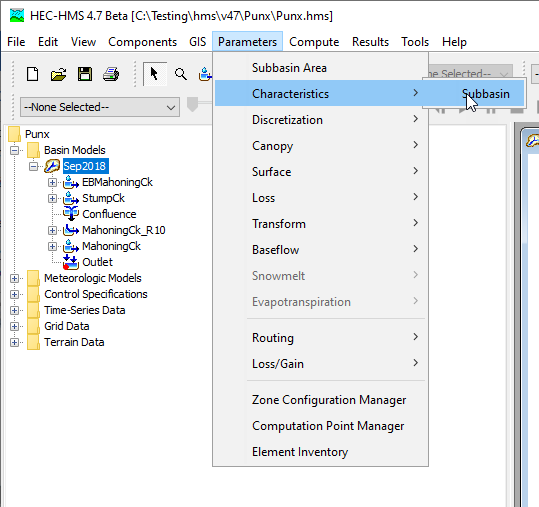
Geospatial subbasin characteristics can be computed within HEC-HMS. To compute subbasin characteristics, the basin model must have georeferenced subbasins and the GIS | Preprocess Sinks step, the GIS | Preprocess Drainage step, and the GIS | Identify Streams step should be computed beforehand. The Subbasin Characteristics view can be accessed from the Parameters | Characteristics menu. The first time the Subbasin Characteristics view is accessed, statistics are computed on-the-fly.
The Subbasin Characteristics computed include:
- Longest flowpath length
- Longest flowpath slope
- Centroidal flowpath length
- Centroidal flowpath slope
- 10-85 flowpath length
- 10-85 slope
- Basin slope
- Basin relief
- Relief ratio
- Elongation Ratio
- Drainage Density
It is important to note that the Subbasin Characteristics calculations are based on the original terrain data associated with the basin model. The calculations are NOT based on output that may exist from the GIS | Terrain Reconditioning step in HMS (build walls / burn streams). Full descriptions for each characteristic are provided below.
The image below illustrates the Subbasin Characteristics view for a basin model.
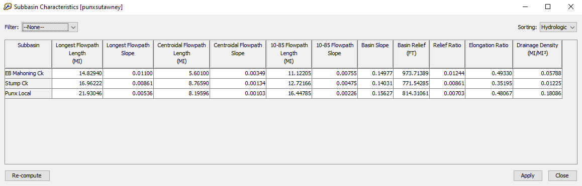
Subbasin Characteristics can be recalculated using the Re-compute button in the lower-left corner of the dialog. The user has the option to override the computed characteristic values by manual editing the table values and clicking Apply to save the changes.
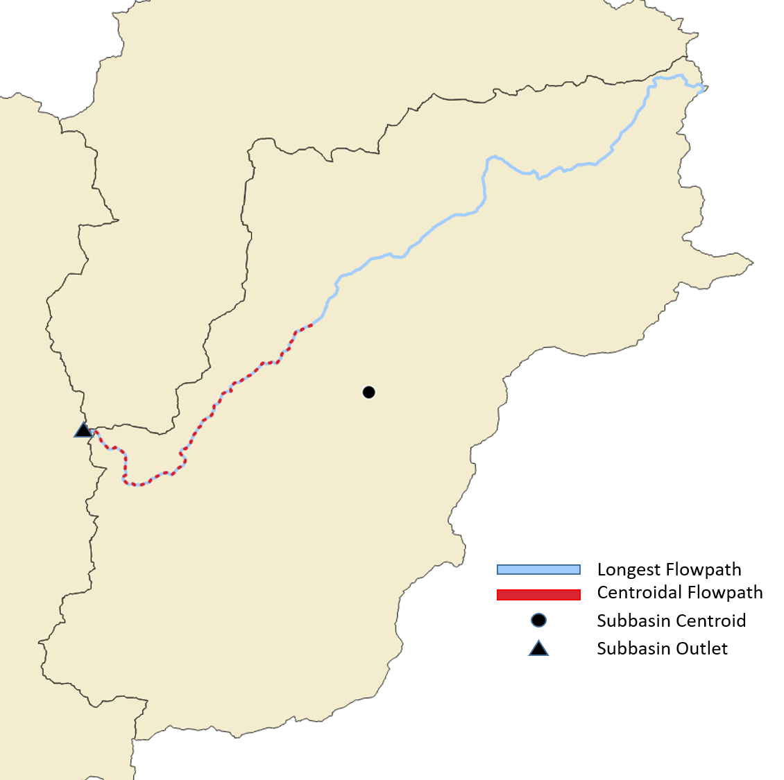
Longest Flowpath (L)
The longest flowpath extends from the subbasin outlet to the most hydraulically-remote point upstream. Longest flowpath is significant in that it is typically used to determine the time of concentration for a watershed.
Centroidal Flowpath (Lca)
The centroidal flowpath is a subset of longest flowpath. It begins at the subbasin outlet and extends upstream along the longest flowpath until it reaches the point along the longest flowpath that is nearest to the subbasin centroid. A comparison of centroidal flowpath and longest flowpath can be seen in the image below.
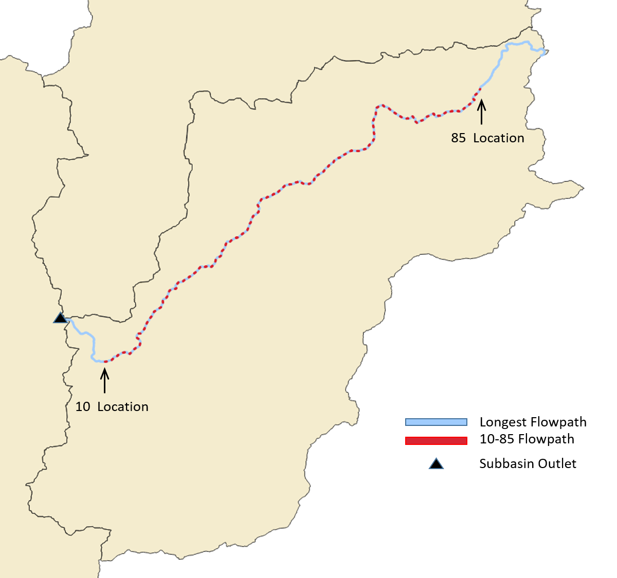
10-85 Flowpath (L10-85, S10-85)
The 10-85 flowpath is also a subset of longest flowpath. Measuring from the outlet in the upstream direction, the 10-85 flowpath begins at a point representing ten percent of the total length of the longest flowpath and ends at a point representing eighty-five percent of the total length. Both the length and the slope of the 10-85 flowpath are provided in the subbasin statistics table, shown above. The 10-85 slope is often more representative of flowpath slopes as a whole within the watershed as it is not affected by the more extreme upstream elevations of the longest flowpath that are typically found near the watershed divide. A comparison of 10-85 flowpath and longest flowpath can be observed in the image below.
Basin Slope (S)
The basin slope represents the average slope of the entire subbasin (rise/run). For each elevation raster value within the subbasin, the algorithm scans the surrounding eight neighbors and computes the slope using the maximum scanned elevation difference. The algorithm does not weigh north, east, south, and west neighbors more than diagonal neighbors; each neighbor is considered equally. The basin slope output is the average of all the computed slope values in the subbasin.
Basin Relief (R)
Basin relief represents the elevation difference between the highest point on the drainage divide and the outlet point of the subbasin.
Relief Ratio (RR)
The relief ratio is simply the basin relief divided by the length of the longest flowpath.
Elongation Ratio (El)
The elongation ratio is a dimensionless ratio used to categorize the general shape of a subbasin. It is a ratio between the diameter of a circle with the same area as the subbasin and the basin length. Elongation ratio values typically range from ~0.2 to 1.0, with lower values representing elongated basins and values close to 1 representing circular basins.
Elongation Ratio = (Area^{0.5} / BasinLength) * (2/ \pi^{0.5})
The HEC-HMS algorithm utilizes the length of the longest flowpath for the BasinLength variable in the above equation.
Drainage Density (DD)
Drainage density is a metric used to describe the efficiency in which a subbasin is drained by stream channels. It is computed by summing the total length of stream channels within the subbasin and then dividing by the area of the subbasin. It is important to note that drainage density that is calculated by HEC-HMS is dependent on the stream threshold used when defining a stream network.
Reach Characteristics
In addition to Subbasin Characteristics, characteristics can also be computed for reach elements within HEC-HMS. As with Subbasin Characteristics, this functionality can be accessed from the Parameters | Characteristics menu. The Reach Characteristics calculators are capable of computing reach slope, reach sinuosity, and reach relief. The calculated results can be viewed in tabular format.
The image below illustrates the Reach Characteristics view for the "MiddleColumbia_WY1997" basin model.
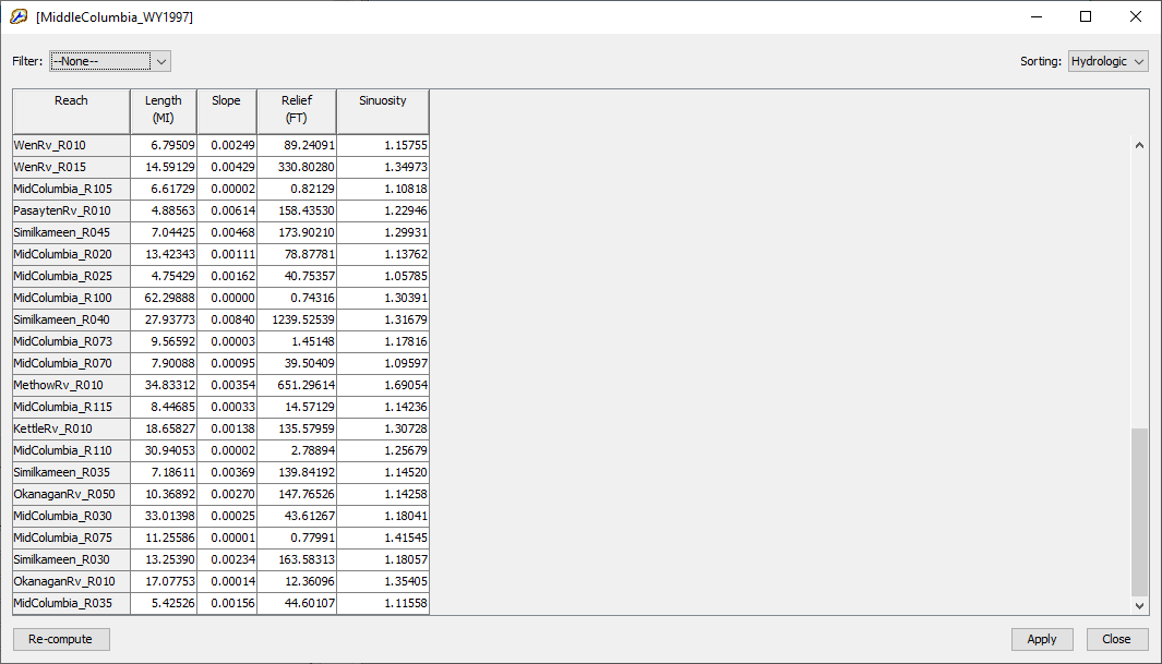
Reach Slope
The reach slope is calculated using the most upstream point of a reach and the most downstream point of a reach (rise/run). The tabular result is presented in standard slope format and not as a percent slope.
Reach Sinuosity
Reach sinuosity is generally defined as the ratio of actual stream length to valley length. It is a descriptive measure that quantifies the degree to which a channel meanders. If the reach is perfectly straight, the reach sinuosity value will be 1. The higher the sinuosity value, the more the reach meanders and deviates from a straight path. The algorithm estimates valley length by computing the straight line length from the most upstream point of the reach and the most downstream point of the reach as demonstrated in the figure below.
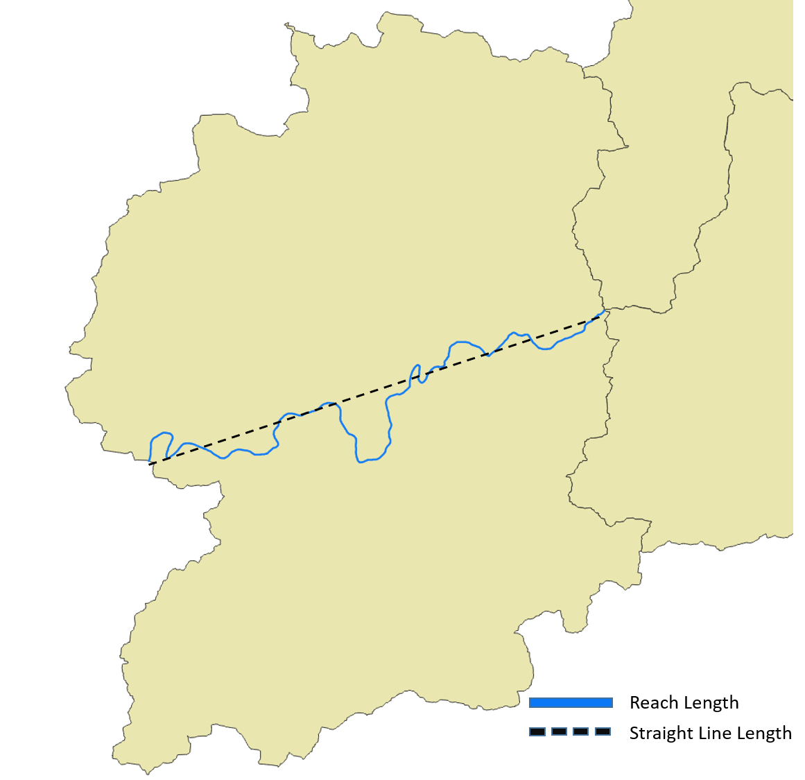
ReachSinuosity = Reach Length / StraightLine Length
Reach Relief
Reach relief represents the elevation difference between the most upstream point of a reach and its most downstream point.