Download PDF
Download page Coordinate Reference Systems.
Coordinate Reference Systems
SHG Grid System
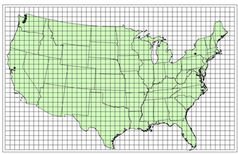
The standard hydrologic grid (SHG) is a variable-resolution square-celled map grid defined for the conterminous United States. The coordinate system of the grid is based on the Albers equal-area conic map projection with the following parameters.
Units: Meters
Datum: North American Datum, 1983 (NAD83)
1st Standard Parallel: 29º 30’ 0” North
2nd Standard Parallel: 45º 30’ 0” North
Central Meridian: 96º 0’ 0” West
Latitude of Origin: 23º 0’ 0” North
False Easting: 0.0
False Northing: 0.0
Users of the grid can select a resolution suitable for the scale and scope of the study for which it is being used. For general-purpose hydrologic modeling with NEXRAD radar precipitation data, HEC recommends 2000-meter cells, and HEC computer programs that use the SHG for calculation will select this cell size as a default. HEC will also support the following grid resolutions: 10,000-meter, 5,000-meter, 1,000-meter, 500-meter, 200-meter, 100-meter, fifty-meter, twenty-meter, ten-meter. The grids resulting from the different resolutions will be referred to as SHG two-kilometer, SHG one-kilometer, SHG 500-meter and so on. The corresponding DSS A-parts are SHG2K, SHG1K, SHG500, SHG100, SHG50, SHG20, and SHG10. A grid identified as SHG with no cell-size indication will be assumed to have two-kilometer cells.
For identification, each cell in the grid has a pair of integer indices (i, j) indicating the position, by cell count, of its southwest (or minimum-x, minimum-y) corner, relative to the grid’s origin at 96ºE, 23ºN. For example the southwest corner of cell (121,346) in the SHG two-kilometer grid is located at an easting of 242000 meter and a northing of 692000 meter. To find the indices of the cell in which a point is located, find the point’s easting and northing in the projected coordinate system defined above, and calculates the indices with the following formulas.
i = floor( easting / cellsize )
j = floor( northing / cellsize )
Where floor(x) is the largest integer less than or equal to x.
Example
As examples of cell identification in the SHG system, indices of cells containing points in the western US and the eastern US will be given in the one-kilometer, two-kilometer, and 500-meter SHG grids.
Western United States: The location 121º 45′ west, 38º 35′ north (near Davis, California) projects to -2185019 meter easting, 2063359 meter northing, in the specified Albers projection. In the SHG two-kilometer system the indices of the cell containing this point are:
i = floor( -2185019 / 2000 ) = floor( -1092.5 ) = -1093
j = floor( 2063359 / 2000 ) = floor( 1031.7 ) = 1031
Eastern United States: The location 76º 30′ west, 42º 25′ north (near Ithaca, New York) projects to 1583506 meter easting, 2320477 meter northing, in the specified Albers projection. In the SHG two-kilometer system the indices of the cell containing this point are:
i = floor( 1583509 / 2000 ) = floor( 791.8 ) = 791
j = floor( 2320477 / 2000 ) = floor( 1160.2) = 1160
In the SHG one-kilometer grid the indices are (1583, 2320), and in SHG 500-meter the indices are (3167, 4640).
Standardized UTM Grid System
The HRAP and SHG systems are undefined outside the conterminous US. To make practical applications of gridded computations in HEC-HMS outside of the CONUS region easier, HEC has developed a grid system based on UTM coordinates, using the cell-numbering conventions of SHG. When using the UTM grid, you must select a UTM zone (including the selection of northern or southern hemisphere) and cell size.
Units: Meters
Datum: World Geodetic System (WGS84)
Projected Coordinate System: Universal Transverse Mercator (UTM)
Zones: 1-60, North(N) or South(S)
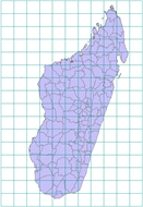
(Example: Island of Madagascar, UTM 38S, cells are 100km square for illustration)
As with SHG, users of the grid can select a resolution suitable for the scale and scope of the study for which it is being used. HEC will support the following grid resolutions: 10,000-meter, 5,000-meter, 2,000-meter, 1,000-meter, 500-meter, 200-meter, 100-meter, fifty-meter, twenty-meter, ten-meter.
For identification, each cell in the grid has a pair of integer indices (i, j) indicating the position, by cell count, of its southwest (or minimum-x, minimum-y) corner, relative to the UTM zone coordinate origin. For example the southwest corner of cell (233, 4077) in a UTM two-kilometer grid is located at an easting of 466000 meters and a northing of 8154000 meters. To find the indices of the cell in which a point is located, find the point’s easting and northing in the projected coordinate system defined above, and calculates the indices with the following formulas.
i = floor( easting / cellsize )
j = floor( northing / cellsize )
where floor(x) is the largest integer less than or equal to x.
Example
As examples of cell identification in a UTM spatial reference system, indices of cells containing points on the west and east coasts will be given in two-kilometer grids based on UTM zone 38S.
West coast: The location 43º 15′ 25" east, 22º 3′ 27" north (near the westernmost point of the island) projects to 320132 meters easting, 755978 meters northing, in the UTM zone 38 south. In a two-kilometer system the indices of the cell containing this point are:
i = floor( 320132/ 2000 ) = floor( 160.061 ) = 160
j = floor( 755978/ 2000 ) = floor( 377.989 ) = 377
East coast: The location 50º 31′ 49" east, 15º 20′ 11" south (near the easternmost point of the island) projects to 449580 meters easting, 8304412 meters northing, in UTM zone 38 south. In a two-kilometer system the indices of the cell containing this point are:
i = floor(449580/ 2000 ) = floor( 224.79) = 224
j = floor(8304412/ 2000 ) = floor(4152.206 ) = 4152
Note that a point at this longitude and latitude falls within the bounds of UTM zone 39 south. However, for this example it is assumed that one grid is being produced for precipitation over the whole island, so the coordinate are calculated for the easternmost zone (39 south) within the bounds of the grid.