Download PDF
Download page Longwave Radiation.
Longwave Radiation
All living and non-living bodies emit longwave radiation. The magnitude of the radiation is proportional to the temperature (measured in Kelvin degrees) of the body raised to the fourth power. Significant sources of longwave radiation in hydrologic applications include the atmosphere itself, and any clouds that may be present locally in the atmosphere. Clouds usually have a higher heat content and higher temperature than clear atmosphere, and therefore there is increased downwelling longwave radiation on cloudy days. Whether the atmosphere and clouds are a net source of longwave radiation to the land surface depends on their temperature relative to the land surface temperature. In most cases, the net longwave radiation is incoming during the daylight hours, and outgoing during the night hours.
The longwave radiation method included in the meteorologic model is only necessary when energy balance methods are used for evapotranspiration or snowmelt. The options available cover a range of detail from simple to complex. Simple specified methods are also available for input of a time-series or grid. Each option produces the downwelling longwave radiation arriving at the land surface. Absorption and radiation by the land surface is computed within the subbasin element. More detail about each method is provided in the following sections.
FAO56
The FAO56 method implements the algorithm detailed by Allen, Pereira, Raes, and Smith (1998). The algorithm calculates the solar declination and solar angle for each time interval of the simulation, using the coordinates of the subbasin, Julian day of the year, and time at the middle of the interval. The solar values are used to compute the clear sky radiation for each subbasin. The computed shortwave radiation is then divided by the calculated clear sky radiation to estimate the fraction of shortwave radiation reaching the ground. Finally, the fraction of shortwave radiation reaching the ground is combined with the vapor pressure to calculate a reduction to the downwelling longwave radiation based on the Stefan-Boltzmann equation.
The FAO56 method includes a Component Editor with parameter data for all subbasins in the meteorologic model; the same data is also shared with the FAO56 shortwave radiation method. When FAO56 is used for both shortwave and longwave radiation, the icon will preferentially show the shortwave icon. A Component Editor is also included for each subbasin. The Watershed Explorer provides access to the longwave component editors using a picture of cloud black body radiation (Figure 1).
An air temperature gage and a windspeed gage must be selected in the atmospheric variables for each subbasin. The water vapor method will require a relative humidity, dew point temperature, or air temperature gage depending on the vapor pressure type selected.
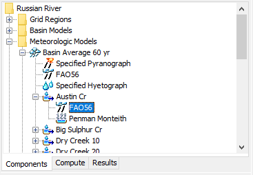
Figure 1. A meteorologic model using the FAO56 longwave method with a Component Editor for all subbasins, and a separate Component Editor for each individual subbasin.
A Component Editor for all subbasins in the meteorologic model includes the central meridian of the time zone (Figure 2). There is currently no specification for the time zone so the meridian must be specified manually. The central meridian is commonly the longitude at the center of the local time zone. Meridians west of zero longitude should be specified as negative while meridians east of zero longitude should be specified as positive. The meridian may be specified in decimal degrees or degrees, minutes, and seconds depending on the program settings.
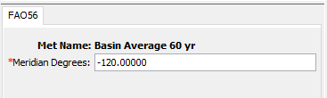
Figure 2. The FAO56 longwave method requires the time zone central meridian.
The Component Editor for each subbasin in the meteorologic model is used to select a vapor pressure type and enter parameter data necessary to account for differences from the clear sky black body radiation (Figure 3). Actual vapor pressure is used as a humidity correction for emitted longwave radiation. Actual vapor pressure can be calculated using the dew point temperature, relative humidity, or daily minimum temperature. The daily minimum temperature option should be used when relative humidity or dewpoint data are not available; the daily minimum temperature option assumes the dewpoint temperature is equal to the daily minimum temperature. Currently the only method for calculating the differences from clear sky radiation is based on elevation. A representative elevation should be entered for each subbasin.
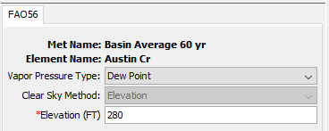
Figure 3. Specifying the vapor pressure type and representative elevation for a subbasin within the FAO56 longwave subbasin Component Editor.
Gridded Longwave
The gridded longwave method is designed to work with the ModClark gridded transform. However, it can be used with other area-average transform methods as well. The most common use of the method is to utilize gridded longwave radiation estimates produced by an external model, for example, a dynamic atmospheric model. If it is used with a transform method other than ModClark, an area-weighted average of the grid cells in the subbasin is used to compute the longwave radiation time-series for each subbasin.
The gridded longwave method includes a Component Editor with parameter data for all subbasins in the meteorologic model. The Watershed Explorer provides access to the longwave component editor using a picture of downwelling radiation from clouds (Figure 4).
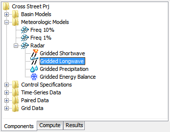
Figure 4. A meteorologic model using the gridded longwave method with a component editor for all subbasins in the meteorologic model.
A Component Editor for all subbasins in the meteorologic model includes the selection of the data source (Figure 5). A radiation gridset must be selected for all subbasins. The current gridsets are shown in the selection list. If there are many different gridsets available, you may wish to choose a gridset from the selector accessed with the grid button next to the selection list. The selector displays the description for each gridset, making it easier to select the correct one.
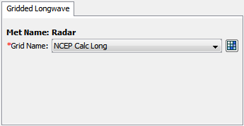
Figure 5. Specifying the longwave radiation data source for the gridded longwave method.
Satterlund
The Satterlund method (Satterlund, 1979) uses temperature and vapor pressure to estimate incoming longwave radiation. While certain physical limits are enforced, the approach is fundamentally empirical. It provides good estimates under mostly clear skies and continues to perform well even as temperature drops below the freezing point. It has the advantage of requiring only readily available meteorologic data.
The Satterlund method includes a Component Editor with parameter data for each subbasin in the meteorologic model. The Watershed Explorer provides access to the longwave component editors using a picture of heat radiation from a cloud (Figure 6).
An air temperature gage and a windspeed gage must be selected in the atmospheric variables for each subbasin. Additionally, the water vapor must be specified with either a relative humidity or dew point temperature gage.
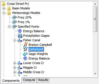
Figure 6. A meteorologic model using the Satterlund longwave method with a component editor for all subbasins in the meteorologic model.
The incoming longwave radiation is computed using a modified form of the equation for ideal black body radiation. The emissivity is calculated as a function of the temperatue, where the temperature coefficient has a default value of 2016 Kelvin. An emissivity coefficient is included for calibration, though the default value of 1.08 is widely used. The emissivity and temperature coefficients can be entered in the Component Editor as shown in Figure 7.
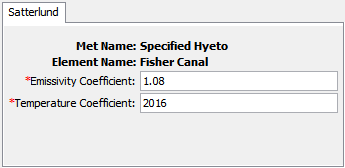
Figure 7. Specifying the thermodynamic properties for each subbasin.
Specified Pyrgeograph
A pyrgeometer is an instrument that can measure downwelling longwave radiation. They are not part of basic meteorological observation stations, but may be included at first order stations. This method may be used to import observed values from a pyrgeometer or it may be used to import estimates produced by an external model.
The specified pyrgeograph method includes a Component Editor with parameter data for all subbasins in the meteorologic model. The Watershed Explorer provides access to the longwave component editors using a picture of heat radiation from a cloud (Figure 8).
The Component Editor for all subbasins in the meteorologic model includes the time-series gage of longwave radiation for each subbasin (Figure 9). A radiation gage must be selected for a subbasin. The current gages are shown in the selection list.
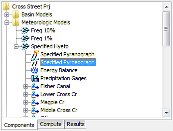
Figure 8. A meteorologic model using the specified pyrgeograph longwave method with a component editor for all subbasins in the meteorologic model.
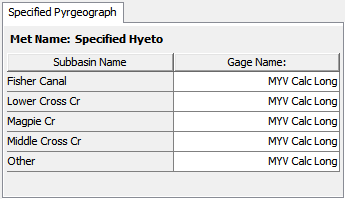
Figure 9. Specifying the longwave radiation time-series gage for each subbasin.