Download PDF
Download page Snowmelt.
Snowmelt
Precipitation generally occurs as snow when the air temperature over the land surface is below the freezing point. In general the snow will accumulate on the land surface so long as the air temperature remains below the freezing point. In some watersheds it is part of the annual hydrologic cycle that snowfall accumulates in a snowpack during the winter months. Snowpacks are not static but undergo continual ice crystal transformations in response to diurnal temperature fluctuations. Ablation or melting of the snowpack occurs when atmospheric conditions transfer energy sufficient to raise the temperature of the snowpack to the freezing point, and then transform the snow to liquid water through the heat of fusion for ice. The most common way to measure the water content of the snowpack is by the snow water equivalent or SWE. The SWE is the depth of water that results from melting a unit column of the snowpack.
The snowmelt method included in the meteorologic model is only necessary when the air temperature may be below the freezing point during a simulation, or a snowpack may exist at the beginning of a simulation. Currently the only option available is a temperature index approach that includes a conceptual representation of the snowpack energy. It computes the liquid water available at the soil surface which is then subject to infiltration and surface runoff. A physically-based energy balance option is under development for a future version.
Gridded Temperature Index
The gridded temperature index method is designed to work with the gridded ModClark transform method. It is the same as the regular temperature index method except the equations for simulating the snowpack are computed separately for each grid cell with separate precipitation and temperature boundary conditions instead of area-averaged values over the whole subbasin. This method can only be used if gridded precipitation is also used. If it is used with a transform method other than ModClark, an area-weighted average of the grid cells in the subbasin is used to compute the boundary condition of the subbasin.
The gridded temperature index method includes a Component Editor with parameter data for all subbasins and a Component Editor with parameter data for each subbasin in the meteorologic model. The Watershed Explorer provides access to the snowmelt component editor using a picture of a snowflake (Figure 1).

Figure 1. A meteorologic model using the gridded temperature index snowmelt method with a component editor for all subbasins.
The Component Editor for all subbasins includes the specification of the temperature boundary condition (Figure 2). A temperature gridset must be selected as the atmospheric boundary conditions on the model. The current gridsets are shown in the selection list. If there are many different gridsets available, you may wish to choose a gridset from the selector accessed with the grid button next to the selection list. The selector displays the description for each gridset, making it easier to select the correct one. The time shift can be used to correct for temperature grids stored with a time zone offset. All calculations during a simulation are computed assuming an arbitrary local time zone that does not observe summer time (daylight savings in the United States). In some cases, the temperature data may be stored in universal time, also known as Greenwich Mean Time (GMT). If the simulation will happen in a local time zone because of other data sources such as observed discharge, select the correct shift so that the temperature data will match the rest of the data. For local time zones West of the zero longitude line, the shift will be negative. For local time zones East of the zero longitude line, the shift will be positive.
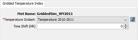
Figure 2. Component editor for all subbasins for the gridded temperature index snowmelt method.
The Component Editor for each subbasin includes the specification of temperature index parameters and initial conditions (Figure 3).
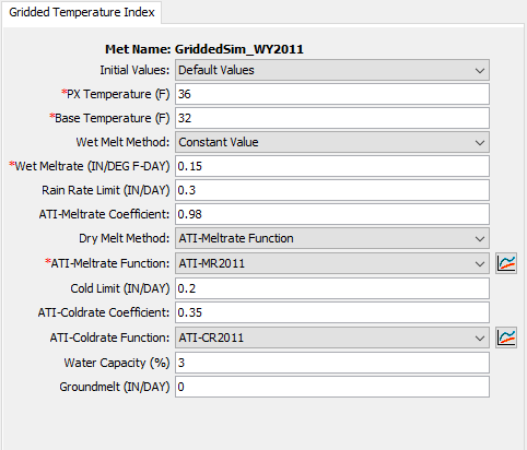
Figure 3. Component editor for the gridded temperature index snowmelt method.
The initial values can be specified with gridsets, or can be initialized to default values. All cells in each subbasin are set to the same default value when the Default Values option is chosen. The default values are: initial SWE of 0 mm, initial cold content of 0 mm, initial liquid of 0%, initial cold content ATI of 0° C, and initial meltrate ATI of 0 DegC-day. Five parameter grids must be selected when the Parameter Grids option is selected; the grids are described in the following paragraphs.
The initial snow water equivalent that exists at the beginning of the simulation must be entered. This information is usually determined by interpolating from actual measurements of snow water equivalent. This value can be set to zero if there is no snow.
The initial cold content that exists at the beginning of the simulation must be entered. It represents the heat required to raise the temperature of the snow pack to 0° C (32° F) and is expressed as a number equivalent to mm (inches) of frozen water. If there is no snow at the beginning of the simulation, it can be set to zero. If there is a snowpack, it can be estimated as the depth of snow multiplied by the snow density multiplied by the heat capacity of snow multiplied by the number of degrees below the freezing point.
The liquid water held within the snowpack at the beginning of the simulation must be entered. Liquid water can persist in the snow only if the snowpack temperature is at 0° C (32°F). There are few conditions when this value can be exactly known. One case is when there is no snowpack and it can be set to zero. A second case is when the air temperature has been continually below freezing for several days and it can be set to zero.
The initial cold content antecedent temperature index is an index to the snow temperature near the surface of the snowpack. It should be set to the approximate snowpack temperature at the beginning of the simulation. If the initial temperature is not known, it can be set to 0° C (32° F).
The seasonal variation of meltrate is indexed by an antecedent temperature function. The initial meltrate ATI should be thought of as similar to "the accumulated thawing degree days." This antecedent temperature function allows the melt rate to change as the snowpack matures and ages. If there is no snow on the ground at the start of the simulation this term can be set to zero. It can also be set to zero if the simulation is starting during or at the end of a cold period when air temperatures were continually below the base temperature. Otherwise it must be calculated as the accumulation of degree-days since the last period of sustained air temperature below freezing.
The PX temperature is used to discriminate between precipitation falling as rain or snow. When the air temperature is less than the specified temperature, any precipitation is assumed to be snow. When the air temperature is above the specified temperature, any precipitation is assumed to be rain. This discrimination temperature may be up to 1° C.
The difference between the base temperature and the air temperature defines the temperature index used in calculating snowmelt. The meltrate is multiplied by the difference between the air temperature and the base temperature to estimate the snowmelt amount. If the air temperature is less than the base temperature, then the amount of melt is zero. Typically, the base temperature should be 0° C.
The wet meltrate is used during time intervals when precipitation is falling as rain, and the rainfall rate is greater than the rain rate limit. It represents the rate at which the snowpack melts when it is raining on the snowpack.
There are two options for specifying the wet melt rate:
- Constant value. A constant value is used to calculate meltrate.
- Annual pattern. A meltrate pattern may be specified that defines the wet meltrate as a function of the time of year. The pattern must be specified separately in the Paired Data Manager before it can be used in the snow melt method. The Paired Data Type should be Parameter Value Pattern with parameter Wet Melt Rate.
The rain rate limit discriminates between dry melt and wet melt. The wet meltrate is applied as the meltrate when it is raining at rates greater than the rain rate limit. If the rain rate is less than the rain rate limit, the meltrate is computed as if there were no precipitation. The default value of 0 mm/day is used if no value is entered, meaning that even a trace of precipitation results in the use of the wet melt rate.
A meltrate must be calculated for time intervals when the precipitation rate is less than the rain rate limit. The calculation starts with the meltrate antecedent temperature index. A coefficient is used to update the antecedent meltrate index from one time interval to the next. The default value of 0.98 is used if no value is entered.
There are three options for specifying the dry melt rate:
- ATI-meltrate function. An antecedent temperature index meltrate function is used to calculate a meltrate from the current meltrate index. The function must be specified separately in the Paired Data Manager before it can be used in the snow melt method. The function should define appropriate meltrates to use over the range of meltrate index values that will be encountered during a simulation. The melt rate for dry conditions typically ranges from 1 to 4 mm/degC-day.
- Annual pattern. A meltrate pattern may be specified that defines the dry meltrate as a function of the time of year. The pattern must be specified separately in the Paired Data Manager before is can be used in the snow melt method. The Paired Data Type should be Parameter Value Pattern with parameter Dry Melt Rate.
- Constant value. A constant value is used to calculate meltrate.
The cold limit accounts for the rapid changes in temperature that the snowpack undergoes during high precipitation rates. When the precipitation rate exceeds the specified cold limit, the antecedent cold content index is set to the temperature of the precipitation. If the temperature is above the base temperature, the cold content index is set to the base temperature. If the temperature is below the base temperature, the cold content index is set to the actual temperature. If the precipitation rate is less than the cold limit, the cold content index is computed as an antecedent index. The default value of 0 mm/day is used if no value is entered, meaning that even a trace of snowfall will reset the cold content.
The cold content antecedent temperature index coefficient is used to update the antecedent cold content index from one time interval to the next. This is a separate index from the one used to update the meltrate index. A default value of 0.5 is used if no value is entered.
An antecedent temperature index cold content function is used to calculate a cold content from the current cold content index. The function must be specified separately in the Paired Data Manager before it can be used in the snow melt method. The function should define appropriate cold contents to use over the range of cold content index values that will be encountered during a simulation. The cold rate typically ranges from 1.22 to 1.32 mm/degC-day.
The maximum liquid water capacity specifies the amount of melted water that must accumulate in the snowpack before liquid water becomes available at the soil surface for infiltration or runoff. Typically, the maximum liquid water held in the snowpack is on the order of 3%-5% of the snow water equivalent, although it can be higher. Liquid water can persist in the snow only if the snowpack temperature is at 0° C; at which point the cold content is zero. The maximum is entered as a percentage of the snow water equivalent.
Heat from the ground can cause snowmelt, especially if the snowpack accumulates on ground that is only partially frozen or completely unfrozen. In these cases the warm ground is insulated by the snowpack. Heat from the warm ground will cause the bottom of the snowpack to melt. Two methods are available for specifying the melting of the snowpack due to contact with unfrozen ground:
- A fixed value can be entered; the same amount of melt is computed for the snowpack regardless of atmospheric conditions above the pack or the time of year.
- An annual pattern can alternately be entered; the pattern specifies the meltrate due to contact with the ground as a function of the time of year. The pattern must be entered in the Paired Data Manager before is can be used in the snowmelt method. The Paired Data Type should be Parameter Value Pattern with parameter Ground Melt Rate.
Temperature Index
The temperature index method is an extension of the degree-day approach to modeling a snowpack. A typical approach to the degree day is to have a fixed amount of snowmelt for each degree above freezing. This method includes a conceptual representation of the cold energy stored in the pack along with a limited memory of past conditions and other factors to compute the amount of melt for each degree above freezing. As the snowpack internal conditions and atmospheric conditions change, the melt coefficient also changes.
The temperature index method includes a Component Editor with parameter data for each subbasin in the meteorologic model. Each subbasin must have at least one elevation band and may have up to ten elevation bands. A separate Component Editor is included for each elevation band. The Watershed Explorer provides access to the snowmelt component editors using a picture of a snowflake (Figure 3).
An air temperature gage must be selected in the atmospheric variables for each subbasin. The gage selected for air temperature must have an elevation defined in the time-series data manager.
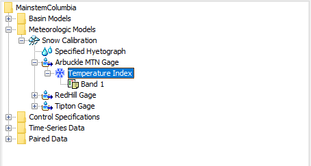
Figure 3. A meteorologic model using the temperature index snowmelt method with a component editor for a each individual subbasin, and a component for each elevation band.
A Component Editor for each subbasin in the meteorologic model includes most of the parameters for the snowmelt method (Figure 4).
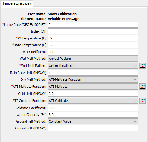
Figure 4. Temperature index snowmelt properties for each subbasin in a meteorologic model.
Each subbasin must have a specified lapse rate, which represents the temperature change per 1000 feet or meters. The temperature for each elevation band is computed using the temperature recorded in the time-series gage, the elevation of the time-series gage, the lapse rate for the subbasin, and the elevation of the elevation band. The adjusted temperature for each elevation band is computed by adding a correction to the specified temperature gage, computed as the lapse rate multiplied by the difference between the band elevation and the gage elevation. The lapse rate should be negative if the air temperature is cooler at high elevation than at low elevation.
An optional precipitation index may be used. In order to use the index, it must be specified for the subbasin as a whole and also for each elevation band. The ratio of the index for the subbasin and the index at an elevation band is used to adjust the precipitation for each elevation band. Indexing is one method to adjust for orographic trends in precipitation.
The PX temperature is used to discriminate between precipitation falling as rain or snow. When the air temperature is less than the specified temperature, any precipitation is assumed to be snow. When the air temperature is above the specified temperature, any precipitation is assumed to be rain.
The difference between the base temperature and the air temperature defines the temperature index used in calculating snowmelt. The meltrate is multiplied by the difference between the air temperature and the base temperature to estimate the snowmelt amount. If the air temperature is less than the base temperature, then the amount of melt is zero. Typically, the base temperature should be 0° C.
The wet meltrate is used during time intervals when precipitation is falling as rain, and the rainfall rate is greater than the rain rate limit. It represents the rate at which the snowpack melts when it is raining on the snowpack.
There are two options for specifying the wet melt rate:
- Constant value. A constant value is used to calculate meltrate.
- Annual pattern. A meltrate pattern may be specified that defines the wet meltrate as a function of the time of year. The pattern must be specified separately in the Paired Data Manager before it can be used in the snow melt method. The Paired Data Type should be Parameter Value Pattern with parameter Wet Melt Rate.
The rain rate limit discriminates between dry melt and wet melt. The wet meltrate is applied as the meltrate when it is raining at rates greater than the rain rate limit. If the rain rate is less than the rain rate limit, the meltrate is computed as if there were no precipitation. The default value of 0 mm/day is used if no value is entered, meaning that even a trace of precipitation results in the use of the wet melt rate.
A meltrate must be calculated for time intervals when the precipitation rate is less than the rain rate limit. The calculation starts with the meltrate antecedent temperature index. A coefficient is used to update the antecedent meltrate index from one time interval to the next. The default value of 0.98 is used if no value is entered.
There are three options for specifying the dry melt rate:
- ATI-meltrate function. An antecedent temperature index meltrate function is used to calculate a meltrate from the current meltrate index. The function must be specified separately in the Paired Data Manager before it can be used in the snow melt method. The function should define appropriate meltrates to use over the range of meltrate index values that will be encountered during a simulation. The melt rate for dry conditions typically ranges from 1 to 4 mm/degC-day.
- Annual pattern. A meltrate pattern may be specified that defines the dry meltrate as a function of the time of year. The pattern must be specified separately in the Paired Data Manager before it can be used in the snow melt method. The Paired Data Type should be Parameter Value Pattern with parameter Dry Melt Rate.
- Constant value. A constant value is used to calculate meltrate.
The cold limit accounts for the rapid changes in temperature that the snowpack undergoes during high precipitation rates. When the precipitation rate exceeds the specified cold limit, the antecedent cold content index is set to the temperature of the precipitation. If the temperature is above the base temperature, the cold content index is set to the base temperature. If the temperature is below the base temperature, the cold content index is set to the actual temperature. If the precipitation rate is less than the cold limit, the cold content index is computed as an antecedent index. The default value of 0mm/day is used if no value is entered, meaning that even a trace of snowfall will reset the cold content.
The cold content antecedent temperature index coefficient is used to update the antecedent cold content index from one time interval to the next. This is a separate index from the one used to update the meltrate index. A default value of 0.5 is used if no value is entered.
An antecedent temperature index cold content function is used to calculate a cold content from the current cold content index. The function must be specified separately in the Paired Data Manager before it can be used in the snow melt method. The function should define appropriate cold contents to use over the range of cold content index values that will be encountered during a simulation. The cold rate typically ranges from 1.22 to 1.32 mm/degC-day.
The maximum liquid water capacity specifies the amount of melted water that must accumulate in the snowpack before liquid water becomes available at the soil surface for infiltration or runoff. Typically, the maximum liquid water held in the snowpack is on the order of 3%-5% of the snow water equivalent, although it can be higher. Liquid water can persist in the snow only if the snowpack temperature is at 0C; at which point the cold content is zero. The maximum is entered as a percentage of the snow water equivalent.
Heat from the ground can cause snowmelt, especially if the snowpack accumulates on ground that is only partially frozen or completely unfrozen. In these cases the warm ground is insulated by the snowpack. Heat from the warm ground will cause the bottom of the snowpack to melt. Two methods are available for specifying the melting of the snowpack due to contact with unfrozen ground:
- A fixed value can be entered; the same amount of melt is computed for the snowpack regardless of atmospheric conditions above the pack or the time of year.
- An annual pattern can alternately be entered; the pattern specifies the meltrate due to contact with the ground as a function of the time of year. The pattern must be entered in the Paired Data Manager before is can be used in the snowmelt method. The Paired Data Type should be Parameter Value Pattern with parameter Ground Melt Rate.
Each subbasin is broken into one or more elevation bands; each band has its own parameter data. One elevation band may be used to represent a subbasin with very little terrain variation. Subbasins with large elevation variations should use multiple elevation bands. Create an elevation band by clicking with the right mouse button on the snowmelt icon under a subbasin (Figure 6). A context menu is displayed that allows you to create a new elevation band. You can also create an elevation band by clicking with the right mouse button on any existing elevation band. The same context menu is displayed that allows you to create a new elevation band. Delete an elevation band by clicking on it with the right mouse button. A context menu is displayed that allows you to delete the elevation band. Clicking on the elevation band icon will access the Component Editor used for each band (Figure 7).
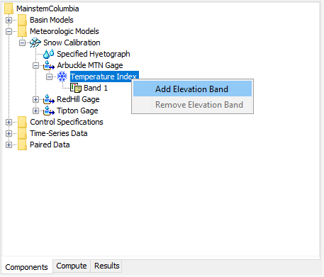
Figure 6. Adding a temperature index elevation band to a subbasin.
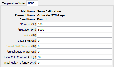
Figure 7. Specifying properties for a temperature index elevation band.
A Component Editor is provided for each elevation band where parameter data defines the relative size of the band, the elevation or the band, and initial conditions for snowpack in the band. You must specify the percentage of the subbasin that each elevation band composes. An elevation band is not required to be contiguous. The percentage specified for each elevation band will automatically be normalized if the sum of the percentages across all subbasins does not equal 100. There is no limit to the number of elevation bands that can be used, but at least one is required. Typically only one band is used in watersheds with small elevation differences. Mountainous watersheds usually require several bands for each subbasin.
Enter the average elevation for each elevation band. Typically the specified elevation will be either the area-weighted elevation of the band, or the average of the highest and lowest points in the band.
The optional precipitation index must be entered in combination with an index value for the subbasin as a whole if you wish to adjust precipitation for each elevation band. In general, precipitation increases at higher elevations in mountainous watersheds.
The initial snow water equivalent (SWE) that exists at the beginning of the simulation must be entered. This information is usually determined by interpolating from actual measurements of snow water equivalent. This value can be set to zero if there is no snow.
The initial cold content that exists at the beginning of the simulation must be entered. It represents the heat required to raise the temperature of the snow pack to 0° C (32° F) and is expressed as a number equivalent to mm (inches) of frozen water. If there is no snow at the beginning of the simulation, it can be set to zero. If there is a snowpack, it can be estimated as the depth of snow multiplied by the snow density multiplied by the heat capacity of snow multiplied by the number of degrees below the freezing point.
The liquid water held within the snowpack at the beginning of the simulation must be entered. Liquid water can persist in the snow only if the snowpack temperature is at 0° C (32° F). There are few conditions when this value can be exactly known. One case is when there is no snowpack and it can be set to zero. A second case is when the air temperature has been continually below freezing for several days and it can be set to zero.
The initial cold content antecedent temperature index is an index to the snow temperature near the surface of the snowpack. It should be set to the approximate snowpack temperature at the beginning of the simulation. If the initial temperature is not known, it can be set to 0° C (32° F).
The seasonal variation of meltrate is indexed by an antecedent temperature function. The initial meltrate ATI should be thought of as similar to "the accumulated thawing degree days." This antecedent temperature function allows the melt rate to change as the snowpack matures and ages. If there is no snow on the ground at the start of the simulation this term can be set to zero. It can also be set to zero if the simulation is starting during or at the end of a cold period when air temperatures were continually below the base temperature. Otherwise it must be calculated as the accumulation of degree-days since the last period of sustained air temperature below freezing.