Download PDF
Download page Dew Point.
Dew Point
Dew Point is the temperature below which droplets condense and form dew. Air temperature is affected by a variety of factors including Latitude, Altitude, Topography, and the presence of Vegetation or Waterbodies. The dew point also plays an integral role in several other meteorologic processes available to be modeled in HEC-HMS including Evapotranspiration and Longwave Radiation.
The Dew Point Method included in the Meteorologic Model is required when certain types of Evapotranspiration Methods or Longwave Radiation Methods are used. Seven methods (Gridded Dew Point Temperature, Gridded Humidity, Interpolated Dew Point Temperature, Interpolated Humidity, Precipitation Index Humidity, Specified Dew Point Thermograph, and Specified Humidograph) are available for adding Dew Point data to the Meteorologic Model. More detail about each method is provided in the following sections.
Gridded Dew Point Temperature
The most common use of the Gridded Dew Point Temperature Method is to utilize radar-based temperature estimates. Using additional software, it is possible to develop a gridded representation of temperature data or to use output from atmospheric models. If it is used with a transform method other than ModClark, an area-weighted average of the grid cells in the subbasin is used to compute the thermograph for each subbasin.
The Gridded Dew Point Temperature Method includes a Component Editor with parameter data for all subbasins in the Meteorologic Model. The Watershed Explorer provides access to the Dew Point Component Editor.

The Component Editor for all subbasins in the Meteorologic Model includes the selection of a datasource. Gridded temperature data must be stored as a temperature grid before it can be used in the Meteorologic Model. The data may be from radar sources or could be the result of complex calculations exterior to the program. Regardless, the grid data must be stored as a temperautre grid. Only temperature grids already defined will be shown in the selection list. If there are many different gridsets available, you may wish to choose a gridset from the selector accessed with the Grid button next to the selection list. The selector displays the description for each gridset, making it easier to select the correct one.
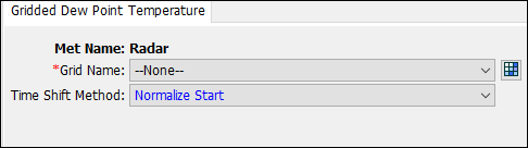
The Time Shift Method can be used to correct timing for temperature grids stored with a time zone offset. All calculations during a simulation are computed assuming an arbitrary local time zone that does not observe summer time (daylight savings in the United States). Normalize Start shifts the time of the first grid in a gridset to the simulation start time.
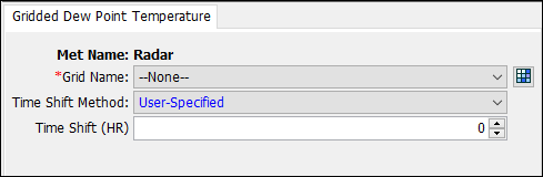
User-Specified allows the user to set the Time Shift from the grid time zone to the local time zone. Set the shift to zero if all the time-series and grid data is referenced in same local time zone. If other data sources such as observed discharge or precipitation are referenced in local time and the temperature grid is referenced to a different time zone, select the correct shift so that the temperature data will match the rest of the data.
Gridded Humidity
The Gridded Humidity Method provides a spatially varied and continuous dataset of humidity measurements. If it is used with a transform method other than ModClark, an area-weighted average of the grid cells in the subbasin is used to compute the humidity for each subbasin.
The Gridded Humidity Method includes a Component Editor with parameter data for all subbasins in the Meteorologic Model. The Watershed Explorer provides access to the Dew Point Component Editor.

The Component Editor for all subbasins in the Meteorologic Model includes the selection of a datasource. Gridded humidity data must be stored as a humidity grid before it can be used in the Meteorologic Model. The data may be from radar sources or could be the result of complex calculations exterior to the program. Regardless, the grid data must be stored as a humidity grid. Only humidity grids already defined will be shown in the selection list. If there are many different gridsets available, you may wish to choose a gridset from the selector accessed with the Grid button next to the selection list. The selector displays the description for each gridset, making it easier to select the correct one.
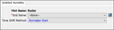
The Time Shift Method can be used to correct timing for humidity grids stored with a time zone offset. All calculations during a simulation are computed assuming an arbitrary local time zone that does not observe summer time (daylight savings in the United States). Normalize Start shifts the time of the first grid in a gridset to the simulation start time.
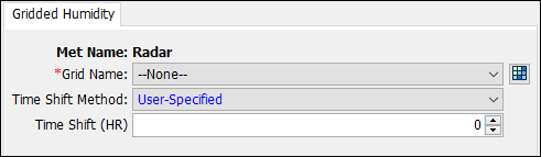
User-Specified allows the user to set the Time Shift from the grid time zone to the local time zone. Set the shift to zero if all the time-series and grid data is referenced in same local time zone. If other data sources such as observed discharge or precipitation are referenced in local time and the humidity grid is referenced to a different time zone, select the correct shift so that the humidity data will match the rest of the data.
Interpolated Dew Point Temperature
Gridded data better captures the meteorology temporally and spatially across a watershed when compared to gage measurements at a single point. However, hourly or sub-hourly gridded meteorology products are not always available, particularly for historic events of interest to the modeler. In these cases, a gridded dataset can be created by interpolating point observations recorded at weather stations. The Interpolated Dew Point Temperature Method allows the user to develop an interpolated dew point temperature grid based on point dew point temperature gage data.
The Interpolated Dew Point Temperature Method includes a Component Editor with parameter data for all subbasins in the Meteorologic Model. The Watershed Explorer provides access to the Dew Point Component Editor. The Component Editor for each subbasin in the Meteorologic Model is used to enter parameter data that defines the Interpolation Method and to select dew point temperature gages to use in the interpolation. The Interpolation Method can be selected from the dropdown menu. An interpolation method must be selected. The user has four interpolation options briefly summarized below.

The Inverse Distance interpolation method assumes the weight, or influence, of a gage is equal to the inverse of its distance from the interpolated cell. The Inverse Distance Squared interpolation method assumes the weight of a gage is equal to the inverse of the square of its distance from the interpolated cell. The Nearest Neighbor interpolation method simply assigns the nearest value to the cell center of interest without considering values of other nearby points. Bilinear interpolation within HEC-HMS relies on triangulation of the irregularly spaced gage locations. Based on the gage coordinates, a Triangulated Irregular Network (TIN) is created to represent the gage network in the basin model coordinate system. This TIN defines triangles, where each gage is a corner of one or more triangles. Given this TIN, a value at any given point is computed by first identifying the triangle in which that point falls, then interpolating within that triangle using Barycentric Coordinates. You must use three or more gages and the gages need to bound all grid cells.
Select Dew Point Temperature Gages in the dropdown rows under the Gage column. The Radius of Influence is an optional parameter and represents the maximum interpolation distance. Beyond its radius of influence, the gage will not affect the cell values of the interpolated grid. Dew point temperature gages used in this method must be loaded in as Time-Series of Temperature Data with defined latitude and longitude information.

An interpolated temperature grid will be created once the simulation has been computed. Once the compute is complete the interpolated grid will be saved with the same name as the Meteorologic Model in DSS format in the HEC-HMS project directory.
Interpolated Humidity
Gridded data better captures the meteorology temporally and spatially across a watershed when compared to gage measurements at a single point. However, hourly or sub-hourly gridded meteorology products are not always available, particularly for historic events of interest to the modeler. In these cases, a gridded dataset can be created by interpolating point observations recorded at weather stations. The Interpolated Humidity Method allows the user to develop an interpolated relative humidity grid based on point relative humidity gage data.
The Interpolated Humidity Method includes a Component Editor with parameter data for all subbasins in the Meteorologic Model. The Watershed Explorer provides access to the Humidity Component Editor. The Component Editor for each subbasin in the Meteorologic Model is used to enter parameter data that defines the Interpolation Method and to select humidity gages to use in the interpolation. The Interpolation Method can be selected from the dropdown menu. An interpolation method must be selected. The user has four interpolation options briefly summarized below.

The Inverse Distance interpolation method assumes the weight, or influence, of a gage is equal to the inverse of its distance from the interpolated cell. The Inverse Distance Squared interpolation method assumes the weight of a gage is equal to the inverse of the square of its distance from the interpolated cell. The Nearest Neighbor interpolation method simply assigns the nearest value to the cell center of interest without considering values of other nearby points. Bilinear interpolation within HEC-HMS relies on triangulation of the irregularly spaced gage locations. Based on the gage coordinates, a Triangulated Irregular Network (TIN) is created to represent the gage network in the basin model coordinate system. This TIN defines triangles, where each gage is a corner of one or more triangles. Given this TIN, a value at any given point is computed by first identifying the triangle in which that point falls, then interpolating within that triangle using Barycentric Coordinates. You must use three or more gages and the gages need to bound all grid cells.
Select Humidity Gages in the dropdown rows under the Gage column. The Radius of Influence is an optional parameter and represents the maximum interpolation distance. Beyond its radius of influence, the gage will not affect the cell values of the interpolated grid. Humidity gages used in this method must be loaded in as Time-Series of Humidity Data with defined latitude and longitude information.

An interpolated humidity grid will be created once the simulation has been computed. Once the compute is complete the interpolated grid will be saved with the same name as the Meteorologic Model in DSS format in the HEC-HMS project directory.
Specified Dew Point Thermograph
The Specified Dew Point Thermograph Method includes a Component Editor with parameter data for all subbasins in the Meteorologic Model. The Watershed Explorer provides access to the Dew Point Component Editors.

The Component Editor for all subbasins in the Meteorologic Model includes the Time-Series Gage of Temperature for each subbasin. A Dew Point Temperature Gage must be selected for a subbasin. The current gages are shown in the selection list.

Specified Humidograph
The Specified Humidograph Method includes a Component Editor with parameter data for all subbasins in the Meteorologic Model. The Watershed Explorer provides access to the Dew Point Component Editors.

The Component Editor for all subbasins in the Meteorologic Model includes the Time-Series Gage of Humidity for each subbasin. A Humidity Gage must be selected for a subbasin. The current gages are shown in the selection list.

Precipitation Index Humidity
The Precipitation Based Humidity Method implements the relative humidity algorithm described within Follum et al, (2015). The method estimates the relative humidity at a specific location (grid cell or subbasin) using the precipitation rate. As such, this method requires the use of a valid precipitation method.
The Precipitation Based Humidity Method includes a Component Editor with parameter data for all subbasins in the Meteorologic Model. The Watershed Explorer provides access to the Precipitation Based Humidity Editor, as shown in the following figure.

The Precipitation Based Humidity Component Editor is shown in the following figure. The user must specify a precipitation rate threshold (in/day or mm/day), wet humidity (%), and dry humidity (%). When the precipitation rate at the location in question exceeds the specified threshold, the wet humidity will be used. When the precipitation rate at the location in question is less than or equal to the specified threshold, the dry humidity will be used.
