Download PDF
Download page v.4.10.0 Release Notes.
v.4.10.0 Release Notes
Initial beta released:
Final release:
New Features
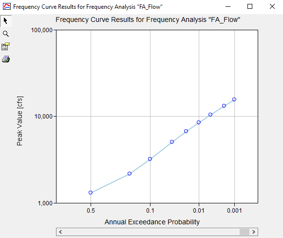
Frequency Analysis Compute
The new Frequency Analysis compute option in HEC-HMS is similar in nature to the existing Depth-Area Analysis framework but with a different end goal in mind. Instead of analyzing multiple points within a watershed at a single frequency, the Frequency Analysis compute option allows the user to analyze a single point over a range of different frequencies. A Frequency Analysis can have one to many ordinates defined, each with their own assigned annual exceedance probability, meteorologic model, and basin model. Currently, the analysis can be used to generate a flow frequency curve or a stage frequency curve at the point of interest.

This feature was funded by the HQ General Investigations (GI) program. Initial code and implementation were done by Josh Willis. Testing was done by Greg Karlovits, Josh Willis, and Matt Fleming.
Interpolated Meteorology
An interpolation option was added to the precipitation, temperature, windspeed, solar radiation, and evapotranspiration methods in the meteorologic model. The interpolation option interpolates between gaged locations and creates a series of grids if interpolating over a gridded domain, or time-series at point locations if interpolating over a non-gridded domain. The interpolation methods include inverse-distance squared, inverse-distance, nearest-neighbor, and bilinear. There is an option to bias correct a precipitation interpolation, and lapse adjust a temperature interpolation. The interpolated result is cached to disk in an HEC-DSS file. The cached result is accessed on subsequent computes, unless a parameterization change occurs invalidating the cache and triggering a re-compute. The time-series gages that are selected for interpolation must be parameterized with a valid longitude and latitude.

The interpolated result is shown using the spatial results feature:

This feature was funded by through the Mississippi River Geomorphology & Potamology program. Initial code implementation was performed by Caleb DeChant, and Thomas Brauer. Documentation and testing was completed by Matt Fleming, Tom Brauer, Mike Bartles, and Simon Evans.
Snow Migration
Snow methods were migrated from the meteorologic model to the basin model. Snowpack accumulation and ablation are a land surface process. Snow parameters now belong to the subbasin and can be adjusted in the subbasin component editor framework and the basin global editor framework. In future versions of the program, snow parameters will be accessible from zonal editors, similar to other basin processes.
Snow parameters will be forward migrated automatically for projects upgrading from prior versions. For every meteorology model that includes snow, linked basin models are copied, and snow parameters are migrated to the basin model copy. Simulations are updated to reference the copied basin model. Lapse rate parameters are migrated from the snow parameterization to the gage air temperature parameterization in the meteorologic model.
The image below illustrates Temperature-Index Snow parameters that have been migrated to the basin model.

In the example below, copies of the Long_Term_Forecast and Winter_Forecast basin models would be created to accommodate snow parameters from Winter_Forecast_wSnow.

In the message log, Warning 20399 is displayed whenever snow parameters are migrated from the meteorologic model to the basin model. The program will only migrate snow parameters to the basin model copies (the basin model name with have "Copy" in the name). The original basin model will remain as it was prior to migrating to HEC-HMS 4.10 or newer, no snow parameters will be migrated to the original/base basin model. You might see multiple copies of the basin model because different meteorologic models, each with snowmelt activated, were linked to the same basin model. After migrating to HEC-HMS 4.10 or newer, you can delete any unnecessary basin model or rename basin models.
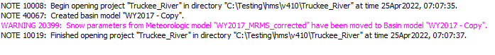
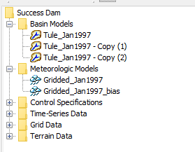
The figure below shows a project after it was migrated from version 4.9 to version 4.10. The Gridded_Jan1997 and Gridded_Jan1997_bias meteorologic models were linked to the Tule_Jan1997 basin model. The following Warning messages were generated when migrating to version 4.10. Since the snow parameters were the same in both meteorologic models, the Tule_Jan1997 - Copy (1) and Tule_Jan1997 - Copy (2) basin models were duplicates. The Tule_Jan1997 basin model was manually deleted. The Tule_Jan1997 - Copy (1) basin model was renamed to Tule_Jan1997.
- WARNING 20399: Snow parameters from Meteorologic model "Gridded_Jan1997" have been moved to Basin model "Tule_Jan1997 - Copy (1)".
- WARNING 20399: Snow parameters from Meteorologic model "Gridded_Jan1997_bias" have been moved to Basin model "Tule_Jan1997 - Copy (2)".
This feature was funded by the CWMS National Implementation Program. Initial code and implementation were done by Tom Brauer. Testing was done by the HEC-HMS team.
Meteorologic Model Restructure
Within previous versions, precipitation, solar radiation, longwave radiation, and evapotranspiration have their own meteorologic methods while temperature, windspeed, dew point, and pressure were only included as part of another method. In this restructure, temperature, windspeed, dew point and pressure will have their own methods. Each meteorolgic method will have at least three options 1) specified gage, 2) gridded data, or 3) no data or none. A full list of the new meteorologic methods are provided in the table below.
Meteorologic Variable | Method |
Air Temperature | Specified Temperature |
Wind Speed | Specified Windspeed |
Barometric Pressure | Specified Pressure |
Dew Point | Specified Dew Point |
Cached Meteorology
As a means to decrease simulation run times, meteorology time-series are cached for subbasins. If the meteorologic model is not updated, the cached time-series will be accessed on subsequent computes.
Note: This only applies for subbasin-average methods; Gridded methods will recompute the meteorology for each grid cell with every compute.
Note: A consequence of cached meteorology is that meteorologic time-series must be written to disk for subsequent access. Meteorologic time-series can not be disabled in the custom time-series results option.
Meteorologic Grid Time Shift
As part of snow migration, grid time shift parameters were added to all gridded meteorologic methods. When gridded snow projects are forward migrated to v4.10, the grid time shift parameter in the snow method will be migrated to the gridded air temperature method.

This feature was funded by the CWMS National Implementation Program. Initial code implementation were done by Paul Ely. Testing was done by Tom Brauer.
Frequency Storm Enhancements
Precipitation-Frequency Grid Importer
Multiple precipitation frequency grids can now be imported to the project's grid data simultaneously from the Precipitation Frequency Grid Importer dialog. This feature also internalizes external source files for the grids by copying them to Project/data directory. To access the dialog, go to File | Import | Gridded Data | Precipitation Frequency.

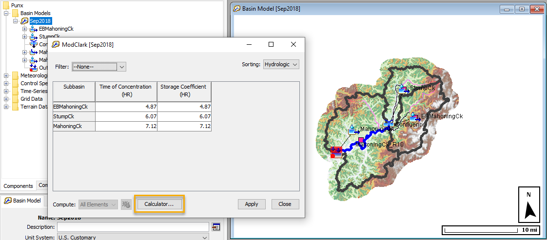
Frequency Precipitation Calculator
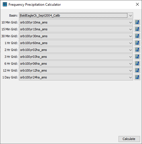
The Frequency Precipitation Calculator can be used to quickly calculate average precipitation depths and apply new precipitation depths at either the watershed or subbasin level. The figure below shows the Frequency Precipitation Calculator is accessed by clicking the calculator button in the Frequency Storm Component Editor. The Frequency Depths Calculator button is only active if the meteorologic model has been linked to a subbasin model that contains georeferenced subbasin elements.
The following figure shows the Frequency Precipitation Calculator. The first step is to select a basin model. The program uses the geometry from the selected basin model to compute the average precipitation depth values. You must also select the correct precipitation-frequency grid for each duration. Once the precipitation-frequency grids are selected, click the compute button to compute average precipitation depths.
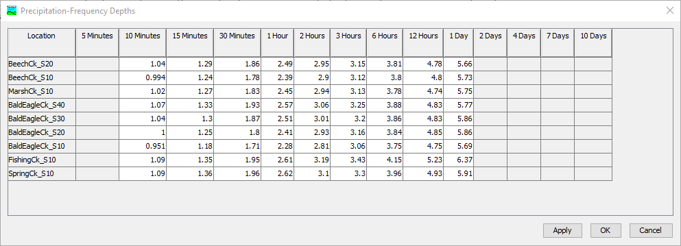
The following figure shows the average precipitation depth for each subbasin in the selected basin model. You can edit values in the table. Click the Apply button and the program will copy the precipitation depth values to the Frequency Storm Component Editor. By default, the program will round the precipitation depth values using the expression calculator precision defined in the Program Settings.
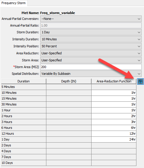
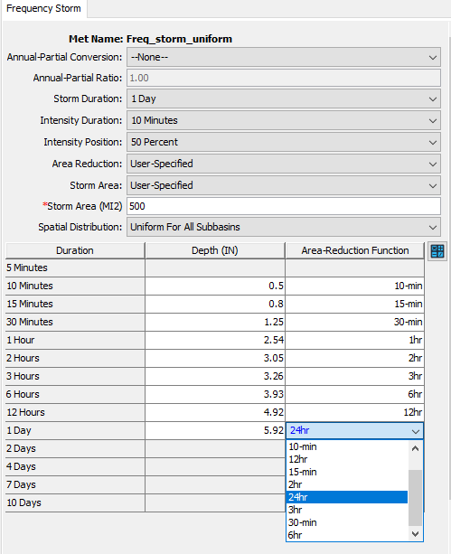
User-Specified Depth-Area Reduction
The frequency storm meteorologic model now allows for a User-Specified area reduction method to be applied. This new method allows the user to specify a depth area-reduction function and apply it to each of the inner durations of a frequency storm.
This feature was funded by the USACE Ft. Worth District in partnership with the Texas General Land Office. Initial code implementation was done by Thomas Brauer, Natasha Sokolovskaya, Daniel Black, Josh Willis, and David Ho. Testing was done by the HEC-HMS team, Simeon Benson, USACE-SWF, and Landon Erikson, USACE-SWF.
Hypothetical Storm Computed Depth Area Checks
Parameter checks were added to the storm depth and storm area values calculated above the computational point for Hypothetical Storm with Precipitation-Frequency Grid precipitation method. The new checks mirror the existing checks in place for user-entered point depth and area reduction.
Legend, Scale Bar, and North Arrow
A legend, scale bar, and north arrow can now be displayed within the desktop when a valid spatial result or calibration metric is selected. These options can be enabled through the View menu. An example of these new visualization items is shown in the following figure:

This feature was funded by the Federal Emergency Management Agency (FEMA). Initial code implementation was performed by Shannon Newbold and Caleb DeChant. Testing was completed by Mike Bartles and Thomas Brauer. Documentation was completed by Mike Bartles.
Time Series Plot Enhancements
Within previous versions, after modifying any part of a plot and recomputing, the changes were removed and the plot was redrawn. Now, users can now modify line styles, add/remove viewports, add/remove marker points/lines, and zoom in/out (amongst other capabilities), and the changes will persist after recomputing.
This feature was funded by FEMA. Initial code implementation was performed by Caleb DeChant, Bryson Spilman, and Shannon Newbold. Testing was completed by Mike Bartles, Thomas Brauer, and Matt Fleming. Documentation was completed by Mike Bartles.
Display Minimum and Maximum Spatial Results
Min and Max buttons were added to the Spatial Results toolbar that allow for quick visualization of the minimum or maximum of any spatial result regardless of the time in which they were achieved. An example of these new visualization items is shown in the following figure:

This feature was funded by FEMA. Initial code implementation was performed by Caleb DeChant and Shannon Newbold. Testing was completed by Mike Bartles, Thomas Brauer, Daniel Black, and Matt Fleming. Documentation was completed by Mike Bartles.
Export Spatial Results
An Export Snapshot button and an Export Recording button were added to the Spatial Results toolbar. The Export Snapshot button, when pressed, will allow the user to export the currently selected spatial result at the current display time step as a GeoTIFF file. The resultant file will be georeferenced and can be read by common GIS software (e.g. QGIS, ArcGIS). The Export Recording button, when pressed, will allow the user to export an animation of the currently selected spatial result to either AVI or MP4 file. The resultant animation will also include any currently displayed maps (e.g. subbasin outlines, reservoir icons, terrain, etc).
This feature was funded by FEMA. Initial code implementation was performed by Caleb DeChant, Shannon Newbold, and Mike Bartles. Testing was completed by Mike Bartles, Thomas Brauer, Daniel Black, and Matt Fleming. Documentation was completed by Mike Bartles.
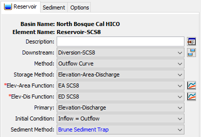
Brune Trap Efficiency Method
The Brune's sediment trap efficiency method (Brune, 1953) was added to the reservoir sediment method. To estimate, the trapping efficiency is based on the ratio of reservoir capacity to mean annual discharge. The Brune's sediment trap efficiency method can calculate the reservoir sediment trap efficiency rate using four input parameters (average annual inflow volume, reservoir capacity elevation, and two constant values (a and b) for use in the Brune curve estimation). The below figure shows the Brune's sediment trap efficiency method has been included in the list of Erosion Methods for a reservoir element. By adding Brune’s trap efficiency method in HEC-HMS, USACE District offices can easily replace their manual excel spreadsheet to estimate the long-term reservoir siltation with HEC-HMS.
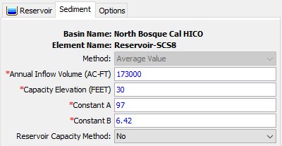
The Brune trap efficiency method was funded by the USACE Arid Regions work unit within the Flood and Coastal Systems Research and Development program. The initial code implementation was done by Paul Ely. Documentation was written by Jay Pak. Testing was done by Jay Pak.
Dynamic Reservoir Volume Reduction Method
The Dynamic reservoir volume reduction method was added to Chen's and Brune's trap efficiency methods for simulating the reservoir/debris basin volume reduction based on sediment/debris inflow from the upstream watersheds. The Dynamic reservoir volume reduction method can update the Elevation-Storage and Elevation-Area curves using two different deposition shape options (Tapered and V-shape). The below figure shows the deposition shape options included in the two sediment methods (Chen's and Brune's trap efficiency methods) for a reservoir element.
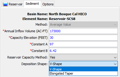
The Dynamic reservoir volume reduction method was funded by the USACE Arid Regions work unit within the Flood and Coastal Systems Research and Development program. The initial code implementation was done by Paul Ely. Documentation was written by Jay Pak. Testing was done by Jay Pak.
Simplex Optimization Improvements
The Simplex optimization method received a number of enhancements that improve the parameter search process. The initial simplex used in the search is now based on the the minimum and maximum values provided by the user, as well as the initial parameter value as before. This change improves the Simplex search's coverage of the parameter value range, but requires that a thoughtful parameter range is set. It also improves the search when the optimum parameter set is at the specified minimum or maximum value. An adaptive search method was implemented that improves the stability and efficiency of the search with a larger number of parameters. It has the trade-off of potentially making an optimization trial take longer, but the search is less likely to get stuck in local minima.
These improvements were part of ongoing work on Optimization and Uncertainty in HEC-HMS, and were funded by the HH&C Science and Engineering Technology (SET) program. Initial code, implementation, and testing were done by Greg Karlovits.
Resume Differential Evolution Optimization
The Differential Evolution solver can now pick up where it left off when the solver terminates in two situations:
- If the solver halts without converging by running out of iterations, the user can increase the maximum number of iterations and the routine will resume the search from where it terminated, as long as the user does not change any other settings.
- If the solver halts by converging prior to reaching the maximum number of iterations, and the user decreases the search tolerance, the routine will resume the search from where it terminated, as long as the user does not change any other settings.
These improvements were part of ongoing work on Optimization and Uncertainty in HEC-HMS, and were funded by the HH&C Science and Engineering Technology (SET) program. Initial code and implementation were done by Greg Karlovits. and testing was done by Greg Karlovits and Matt Fleming.
Normalized Nash-Sutcliffe Efficiency Optimization Objective Function
The Nash-Sutcliffe objective function was replaced in the Optimization Trial only (not elsewhere in the software) with the Normalized Nash-Sutcliffe Efficiency, which has better properties for bounded optimization and avoids issues that arise with penalizing the regular Nash-Sutcliffe objective function for out-of-range parameters. Maximizing the Normalized Nash-Sutcliffe will always maximize the regular Nash-Sutcliffe objective function but will not run into numerical issues when parameter values are close to their bounds.
This change was part of ongoing work on Optimization and Uncertainty in HEC-HMS, and were funded by the HH&C Science and Engineering Technology (SET) program. Initial code, implementation, and testing were done by Greg Karlovits.
Peak-Weighted Variable Power Optimization Objective Function
An experimental objective function was added to the Optimization Trial with the intent of better differentiating between high- and low-flow periods. It is similar in intent and computation to the peak-weighted root-mean-square error objective function already utilized in HEC-HMS, but much more substantially penalizes the objective function during periods where the observed data are high in magnitude and the model error is high. The Peak-Weighted Variable Power objective function can be used with the minimization goal.
First, range-normalize the observed flow time series Q_{obs}, and create a new time series Q_{obs}^{\prime}. Each value of Q_{obs}^{\prime} is on the range [0,1].
Q_{obs}^{\prime}=\frac{Q_{obs}-min(Q_{obs})}{max(Q_{obs}) - min(Q_{obs})}
Then, compute the absolute residual for each time step, raised to the power of Q_{obs}^{\prime}+1 for the time step. Call the exponentiated absolute residual for timestep t with model parameters \theta, \epsilon_{t}|\theta.
\epsilon_{t}|\theta=\lvert (Q_{sim,t}|\theta)-Q_{obs,t} \rvert^{(Q_{obs,t}^{\prime} + 1)}
The exponent has a value of 1 for any timestep where the observed flow is at the minimum observed flow, and a value of 2 for any timestep when the observed flow is at the maximum observed flow. The objective function is computed as f(\theta)=\sum_{t}\epsilon_{t}|\theta, and for optimization this objective is minimized.
This feature was part of ongoing work on Optimization and Uncertainty in HEC-HMS, and was funded by the HH&C Science and Engineering Technology (SET) program. Initial code, implementation, and testing were done by Greg Karlovits.
Calibration Results Map Layer for Flow and SWE
This feature adds new visual aids for at-a-glance assessment of the calibration state of a basin model. Computed statistical metrics, such as Nash Sutcliffe Efficiency (NSE), Coefficient of Determination (R2), Root Mean Square Error / Standard Deviation (RSR), and Percent Bias (PBIAS), are used to color-code each subbasin.

This feature can be accessed via HEC-HMS's Spatial Results Toolbar as shown above. For more information, refer to Viewing Calibration Results.
This feature was implemented as a part of ongoing GIS work. Funding sources include the Corps Water Management System (CWMS) National Implementation Program and the Risk Management Center (RMC). Initial code implementation and documentation was performed by Nick Van. Testing was completed by Thomas Brauer and Mike Bartles.
Global Basin Editors
Global Basin Editors have been added for all methods in the following processes: Discretization, Canopy, Snow, Surface, Loss, Transform, Baseflow, Channel Routing, and Evapotranspiration. The new basin global editors launch an expression calculator whenever the basin is composed of two-dimensional spatial elements. For more, see Parameter Estimation.
Initial code implementation was performed by Thomas Brauer, Caleb DeChant, Bryson Spilman, Natasha Sokolovskaya, and Mike Bartles. Documentation and testing was completed by the entire HEC-HMS team.
Snowmelt Plot
A new plot is now available for simulations that use a valid snowmelt method. The snowmelt plot contains three viewports that display Precipitation, Air Temperature, and Observed and Computed Snow Water Equivalent (SWE). The Air Temperature viewport also includes marker lines for the selected subbasin's PX and Base Temperature parameters.

The Snowmelt Plot can be accessed by selecting Snowmelt Graph either through the Results Menu or by right-clicking the desired subbasin icon within the basin map. The option to select the Snowmelt Graph will only be displayed for Simulation Runs, Forecast Alternatives, Depth Area Simulations, or Optimization Trials that include a valid snowmelt method.
Funding sources for this feature included the Corps Water Management System (CWMS) National Implementation Program. Initial code implementation was done by Simon Evans, Mike Bartles, and Tom Brauer. Documentation was done by Simon Evans. Testing was completed by Mike Bartles.
Air Temperature Spatial Result
Air Temperature has been added to the list of available spatial results when using a snowmelt method, as shown in the following image.

Funding sources for this feature included the HH&C Science and Engineering Technology (SET) program. Initial code implementation and documentation was performed by Mike Bartles. Testing was completed by Matt Fleming.
2D Diffusion Wave Transform and 2D Sediment Transport Enhancements
Both the HEC-RAS and HEC-HMS team make continual improvements to the shared 2D Solver and this release contains the latest rollup of fixes and improvements. These changes were made to improve computational speed, stability, and accuracy of the 2D results. As such, you may notice subtle changes in hydraulic results. Please see the latest HEC-RAS v6.2 Release Notes for further details.
Initial code implementation and documentation for this feature was performed by Alejandro Sanchez and Mike Bartles. Testing was completed by Alejandro Sanchez, Jay Pak, Matt Fleming, Tom Brauer, and Mike Bartles.
Basin Element Area Variable Added to the Global Editor Expression Calculator
A basin element area variable can now be selected in the global editor expression calculator in conjunction with basin characteristics and grids. The funding source for this enhancement includes the HH&C Science and Engineering Technology (SET) program. Initial code implementation and testing were performed by Tom Brauer and Josh Willis.
Units Added to Slopes in the Subbasin and Reach Characteristics Editors
In previous versions of HEC-HMS, flowpath slopes were listed as unitless ratios (rise/run). For clarification, flowpath, basin, and reach slopes are now listed in either FT/FT or M/M.

Added Ability to Enable/Disable Messages to OS Console in Program Settings
The user can now choose to write messages (Errors/Warnings/Notes) to their OS console by setting it in Tools | Program Settings | Messages.
Improvements added for Processing and Applying Gridded Temperature
The gridded Hamon ET method required gridded temperature for the entire day. The program processes the gridded temperature data and computes a daily average temperature grid. The program would stop a simulation and issue an error message if temperature grids were not available for the entire first day of the simulation. An enhancement was added where the program will compute the average daily temperature for the first day of the simulation even if temperature grids are not defined starting at the beginning of the day.
Relaxed Requirement for User-Defined Pattern Hypothetical Storm Patterns to be Strictly Increasing
In the User-Specified Pattern method for the Hypothetical Storm, the requirement that the depth percentage pattern be strictly increasing has been relaxed so that it can now be non-decreasing instead. The time percentage pattern must still be strictly increasing. This allows for users to specify repeating values of total depth percents which imply that the incremental precipitation is zero.
Added File Override Warning and File Saved Dialogs
When saving files (e.g. shapefiles, GeoTIFF, .html, etc) to disk, if a file with the specified path and name already exist, a warning dialog will be shown. Also, when the file is successfully saved, a success dialog will be shown which contains two buttons: one that can copy the path to the file to the clipboard and another that will open a file explorer to the location of the saved file.
Exposed Differential Evolution Initial Random Seed in the User Interface
The Differential Evolution search method in the Optimization Trial relies on random generation of parameter values to create the initial population and each iteration of the search. The random generation relies on a pseudorandom number generator, which can be seeded with an initial seed value that allows the random generation sequence to be repeated. If a DE search is run with the same settings and seed, the results will always be the same.
Bugs Fixed
The following bugs were present in previous versions and have been fixed within version 4.10.
Optimization Trial would Fail to Find Reasonable HMR 52 Storm Parameters when using the Simplex Search Method
The initialization scheme for the simplex used in the Simplex search in previous versions of HEC-HMS would sometimes place several nodes of the simplex (and therefore the storm) far outside the watershed boundary, resulting in no rainfall applied to the watershed for those nodes and a false convergence of the search. The new initialization scheme ensures that the storm will begin within the user-specified coordinate ranges and generally prevents this issue from occurring. It is however incumbent upon the user to specify good parameter ranges for the HMR storm prior to beginning the search.
No evapotranspiration computed when gridded meteorologic methods are combined with non-gridded transform
In v4.9, no evapotranspiration was computed when the met model used gridded air temperature and gridded evapotranspiration, but the subbasin used a non-gridded transform. In HMS v410, since the subbasin is non-gridded (i.e. lumped), area-weighted temperature is calculated for the subbasin. Then evapotranspiration is calculated for the subbasin using the area-weighted temperature and the subbasin latitude and longitude. There is a slight difference in the calculated evapotranspiration between v 4.8 and v4.10, since temperature is averaged before calculating evapotranspiration, and the subbasin latitude and longitude are used instead of the grid cell latitude and longitude.
Negative baseflows would sometimes be generated with linear reservoir model
Linear reservoir baseflow GW coefficient less than half of the simulation time step is replaced with 0.5 * time step. In v.4.9, the replacement did not happen in some cases, which could result in negative baseflow. This was fixed in 4.10.
Sliver Polygons within the Subbasin Boundary would Generate Unreasonable Flow when Applying the HMR 52 Storm
In some cases, small sliver polygons around the boundary of a subbasin element would cause the HMR 52 Storm computation to return unrealistic precipitation values. As described in this post, https://discourse.hecdev.net/t/hmr-52-storm-issue-when-subbasin-element-has-sliver-polygons/2041, the work around was to manually remove the sliver polygon outside of HEC-HMS and then update the HEC-HMS geometry. A check was added when the program reads in the subbasin geometry and if the sliver polygons are encountered then the vertices that make of the slivers are removed.
Failure to Copy Terrain when Reprojection Required
When associating a Terrain Data with a Basin Model, copying terrain data to the basin GIS folder failed whenever a reprojection was required to convert from the terrain Coordinate Reference System (CRS) to the basin CRS. This resulted in no terrain data visible in the basin map. This issue was introduced in v4.9 and has been fixed in v4.10.
Raster Properties Editor Minor UI Fixes
In the Raster Properties Editor, labels now persist after saving the display properties. Color ramps that do not have a default scale will be using the data min and max by default.
Hamon Evapotranspiration Method will Compute without Temperature Method
Simulations containing the Hamon Evapotranspiration method would compute successfully without an Air Temperature method selected. If the Hamon Evapotranspiration method is selected in the Meteorologic model, and an Air Temperature method is not selected, the simulation would still run successfully. This would occur if the "Replace Missing" option in the Meteorologic model is set to either Abort Compute or Set to Default. This has been fixed so that the simulation correctly aborts when no Air Temperature method is selected.
Initial Outflow Parameter was not Available for Kinematic Wave Routing
The Initial Outflow parameter was not available in the Paired Data Dialog for Parameter Value Samples paired data, resulting in no selectable parameters for the Kinematic Wave routing method. This caused the Paired Data Dialog to not function properly (reset back to previously selected method) if the Kinematic Wave routing method was selected. The bug was fixed and Initial Outflow is now available as one of the paired data options for calibration.
Reach Characteristics not Fully Computing after Re-delineation of an Existing Basin
If reach characteristics were already computed on an existing basin and then the basin was modified by re-delineation, errors were encountered when re-computing reach characteristics on the newly re-delineated elements. A fix was implemented that now allows the reach characteristics computations to successfully compute for all reach elements in the basin, new and existing.
Spatial Results would not be Displayed in Basin Models that Mix Clark and ModClark Transform Methods.
An issued was encountered where spatial results were not displayed within a basin model where a majority of the subbasins used the ModClark transform method and then a few used the Clark transform method. This issue has been corrected. Spatial results are now displayed when mixing gridded and lumped transform methods.
Calibration Results (Flow) Would Not Be Displayed if One Out of Many Subbasin Does Not Have an Observed Flow
An issue was encountered where calibration results were not displayed if one of the subbasin does not have an Observed Flow. This issue has been corrected. Calibration Results (Flow) should now color as intended based on statistics metrics, and would not be colored if there is no observed flow for that subbasin.
Color Scales Updated to Reflect Moriasi ET. al. 2007 and 2015 Performance Evaluation Criteria
The Calibration Results display properties editor used outdated performance evaluation criteria. The color scales have now been updated to reflect the Moriasi et. al. 2007 and 2015 performance evaluation criteria. In particular, the following criteria are used:
- Table 9 metrics in Moriasi et. al. 2015 paper for R2, NSE, and PBIAS
- Table 4 metrics in Moriasi et. al. 2007 paper for RSR
Below is a table showing the combined performance criteria from the two papers.
| Performance Rating | Color Code | R2 (2015) | NSE (2015) | RSR (2007) | PBIAS (2015) |
|---|---|---|---|---|---|
| Very Good | Dark Green | 0.85 < R2 ≤ 1.00 | 0.80 < NSE ≤ 1.00 | 0.00 < RSR ≤ 0.50 | PBIAS < ±5 |
| Good | Light Green | 0.75 < R2 ≤ 0.85 | 0.70 < NSE ≤ 0.80 | 0.50 < RSR ≤ 0.60 | ±5 < PBIAS ≤ ±10 |
| Satisfactory | Orange | 0.60 < R2 ≤ 0.75 | 0.50 < NSE ≤ 0.70 | 0.60 < RSR ≤ 0.70 | ±10 < PBIAS ≤ ±15 |
| Unsatisfactory | Red | R2 ≤ 0.60 | NSE ≤ 0.50 | RSR > 0.70 | PBIAS ≥ ±15 |
Illegal Character in File Path would Freeze the Program
An illegal character in a file path, such as an extra ":", entered into a file path of the Paired Data Editor or Precipitation Grid Importer would freeze the program. The issue was corrected and such a character now would result in the path highlighting red to be corrected.
Error 10000 When Loading Project Using Uncertainty Analysis With Layered Green-Ampt Loss
If a project was set up to run an Uncertainty Analysis with any parameters from the Layered Green-Ampt loss rate method, the program would fail to load those parameters from file and throw an Error 10000. The program now loads those parameters correctly.
Optimization Trial Parameters With Lower Bounds Less Than Upper Bounds Incorrectly Throwing Error 17506: "Maximum value is less than minimum value for parameter"
In certain situations, HEC-HMS would incorrectly throw Error 17506 "Maximum value is less than minimum value for parameter" even when the maximum value was greater than the minimum value for an optimization parameter. This bug mainly occurred when one of the values was entered with a decimal place and the other as an integer.
Paths to Some Grid Data and Terrain Data not Updating when Renaming Project
The paths to terrain data file and to non-DSS gridded data files would not update when renaming a project. The paths were also not updating for any gridded data that had its data editor window open. These file paths now update properly.
Hypothetical Storm Becomes Uneditable After Renaming Basin
In v4.6 a precipitation-frequency grid option was added to the hypothetical storm. With the precipitation-frequency grid option there is an option to select a computation point for determining the area of depth-area reduction calculations. The computation point selection requires knowledge of the basin models associated with the meteorologic models, and the computation points within each basin. An issue was found when users renamed a basin model, the hypothetical storm editor panel would not update based on the basin model rename. This issue has been resolved for v4.10.
Hypothetical SCS-Type and Area-Dependent Pattern Storm does not Compute Following a Run with Precipitation Method Set to Precipitation-Frequency Grid
Attempting to run SCS-Type or Area-Dependent Pattern Hypothetical Storm would sometimes result in aborted run with a non-specific message sent to the console. This happened following a run with the 'User-Specified Pattern' and 'Precipitation-Frequency Grid' methods selected for the same storm. The issue was corrected by properly resetting precipitation method to 'Point depth' when the 'SCS-Type' or 'Area-Dependent Pattern' are selected.
Map Did Not Display the Updated Identified Streams When the Stream Threshold Was Updated
The map failed to display the identified streams with the new stream threshold when the stream threshold was updated. This issue was limited to visualization only, as the underlying raster was properly updated and subsequent GIS processing steps were not effected. This bug has been resolved, and the map will now display the raster correctly when the stream threshold changes.
Some Reservoir Element Time-Series Table Fails to Open
A bug was discovered in which some reservoir element time-series tables failed to open and displayed a blank dialog. This issue has been resolved for v4.10.
Non-SHG Albers gridded precipitation compute fail
Special handling logic was added to HEC-HMS to handle the case of Non-SHG Albers gridded precipitation. HEC-DSS does not define a valid Coordinate Reference System for the non-SHG Albers projection. Logic was added to HEC-HMS to recognize the projection as Non-SHG Albers and build a Coordinate Reference System from projection parameters.
Raster Properties Editor to Use Basin Map Tooltip Precision for Precision
Raster Properties Editors in HEC-HMS have been updated to use the precision set in Tools | Program Settings | Basin Map | Basin Map Tooltip Precision.
Error 10000 When No Parameter Set In Uncertainty Analysis
In the Uncertainty Analysis, if an uncertainty element was set but not the specific parameter type, an Error 10000 would be produced and HMS would need to be restarted. A more helpful error message to capture this situation was added.
Error 46551 When Los Angeles Debris Method EQ 2-5 is selected for areas out of 3.0 to 200.0 square miles.
If the Los Angeles Debris Method EQ 2-5 is selected for areas out of 3.0 to 200.0 square miles, a Warning message will be produced instead of the Error 46551 message.
Rename Project Drops Non-HEC-HMS files Located in the Project Directory
In prior versions of HEC-HMS, renaming a project would result in the deletion of some non-HEC-HMS files located in the project directory and sub-directories (i.e. spreadsheets, Word documents, etc.). This issue has been resolved for v4.10.
Negative flows computed when Diversion has no Downstream Element
Fixed an error that prevented access to the diverted flow if the downstream node was not defined. This issue manifested with WARNING 41201: Negative inflows passed to reach.
Animation Framerate Did Not Change When Saved
Fixed a bug where the Animation Toolbar properties editor's frame rate was not applied when set.
Debris Volume Did Not convert for each grain size based on the unit weight
Fixed an issue with the Debris Volume Conversion Calculation by replacing the specific gravity with unit weight. Because the specific gravity approach calculation overestimates the debris volume by considering a solid soil volume.
Reach Hydraulic State for Sediment Routing
Reach flows at nodes are passed to the reach sediment computer using a reach state container. The code that initializes the reach state container was modified so it is correctly initialized for the second pass through the stream network.
Muskingum-Cunge Routing on Second Pass through Stream Network
Muskingum-Cunge routing has an internal time variable that tracks time from the beginning of the simulation. This variable is reset for each pass through the stream network.
Kinematic Wave Routing
Kinematic wave routing was using the minimum number of subreaches instead of the number of subreaches calculated from index flow and celerity. The code has been changed to use the number of subreaches calculated from index flow and celerity.
Kinematic Wave Routing and Sediment Calculations
In previous versions, the reach hydraulic states generated by kinematic wave routing was not being retrieved correctly when calculating sediment transport. This issue has been fixed.
Sediment Deposition Limit
Muskingum-Cunge and Kinematic Wave routing use adjustable time steps to compute flow routing. For each computational period, the last time step is truncated to match the end-of-period time. A sediment deposition limit based on flow depth, fall velocity, and time step was calculating a lower deposition limit for the truncated time step. This resulted in excess sediment outflow. The code was modified to calculate the deposition limit using the time step before the truncated time step.
Volume Ratio Sediment Routing
In certain cases, the outflow volume is greater than the volume of water in the channel. The volume ratio routing method would then generate more sediment than is available in the channel. The method was modified so the outflow sediment is not greater than the available sediment.
Failure to Abort Compute when Gridded Hamon ET Encountered Missing Temperature Data
When missing temperature data was encountered by the Gridded Hamon ET method, the simulation would fail to abort when missing temperature data was encountered, but would instead continue to compute with ERROR 24150 displayed in the console for each time step. This has been fixed so that the simulation aborts at first occurrence of missing data.
Meteorology Model Component Editor Basins Tab Did Not Respond to Method Selection
The Basins tab did not appear and disappear as expected when switching between Gridded Precipitation and other precipitation methods within the same meteorology model. The issue has been fixed and Basins tab disappears when Gridded Precipitation is selected and comes back on when another precipitation method is selected.
Import Georeferenced Elements could cause HEC-HMS to crash
In previous versions, HEC-HMS would crash if the user specified a GIS shapefile without a text attribute field (used to name the imported elements). A user-prompt was added to remind the user that a field definition (text field) must be selected. The software crash is now avoided in this scenario.
2D Diffusion Wave Component Editor Unit Labels
In previous versions, when changing the basin model unit system, the units within the 2D Diffusion Wave component editor labels didn't properly update. Now, these labels change whenever the basin model unit system is changed.
Standard Report Fails to Generate Report for Depth-Area Analysis Simulations
Fixed a bug where the standard report fails to generate report for depth-area analysis simulations.
Spatial Results Fail to Update when Computing to Point
In previous versions spatial results failed update when using the compute to point option. Spatial results are now updated upstream of the computation point when using the compute to point option. Spatial results downstream of the computation point remain unchanged.
Draw Properties for Shapefiles Not Saving Correctly
Previous software versions allowed you to edit the draw properties for a shapefile displayed in a basin model. A bug was reported that draw properties were not being correctly applied for the case where the same shapefile was selected across multiple basin models. This issue has been fixed, the program correctly tracks the draw properties for each shapefile independent of the basin model.
2D Diffusion Wave and Gridded Loss Methods
Model simulations would abort when using the 2D Diffusion Wave transform and gridded loss methods (e.g. Gridded Curve Number). The program was not able to correctly find the correct value for each cell in the 2D mesh. This issue has been fixed, the program can correctly overlay the 2D mesh with the parameter value grids.
User Specified Pattern Hypothetical Storm - Bad Interpolation Values
If the user-specified dimensionless (%-%) storm time pattern for the User Specified Pattern Hypothetical Storm lacked a 0, 0 entry to begin the table, first timestep interpolation would result in nonsensical large negative values if the model timestep length was shorter than the time to the first ordinate. Tables lacking a 0, 0 and/or a 100, 100 entry now throw an error and halt the simulation.
Failure to Update all Subbasins when Changing Discretization Method from File-Specified to Structured
When attempting to change the discretization method for all subbasins from the Parameters | Discretization | Change Method menu, the process would fail to update all subbasins when changing from file-specified discretization to structured discretization.
Failure to Compute Downstream Elements when Computing to a Computation Point
By default the "Compute all components even if unchanged" program setting is selected. When selected, the program computes all elements in the basin model when you compute a simulation. When this option is unchecked, the program keeps track of when basin model elements were last modified and will only re-compute those elements that were modified since the last simulation or those downstream of the element that change. The compute to point option (right click on a computation point and choose compute to point) is a quick way to run only a portion of the hydrologic network. There has been a bug in the logic the program used to determine if elements needed to be recomputed when running to the model to an computation point. The logic has been improved and the program correctly re-computes elements when using the compute to point feature.
Depth Area Analysis Time-Series Results for Elements using Special Characters in Element Names
We found that time-series table results would not be available for elements with special characters in the name, like "/". This issue has been fixed and now time-series results are displayed when special characters are used in element names.
Difficulty Moving a Break Point
Break points must fall on top of grid cells making up the Identified Streams layer. We found an issue where it seemed like trying to move a break point was impossible. This issue was caused by having multiple raster layers visible in the basin model map and hillshading activated in the display properties. This issue has been fixed, you can easily move break points regardless of the visible GIS raster layers.
Feature Labels for Shapefiles
The editor for displaying shapefiles in the basin model map contains a tab for activating display of labels. The drop down menu for displaying which attribute to use for the labels was not working. This issue has been fixed, you can now select attributes to use as labels for point, line, and polygon shapefiles.
Store Gridded State Variable Results Option Removed from Program Settings
The Results tab in the Program Settings editor contained an option to store gridded state variables. This option use to work in HEC-HMS version 4.4 and when turned on, the program would write gridded snow state variables, and other state variables, to the output DSS file. This capability was replaced with the new spatial results option. Gridded state variables are no longer written to the output DSS file; therefore, this option was removed from Program Settings.
Gridded Temperature with non-Gridded Hamon ET
Warning messages were generated the first time a simulation was computed that used gridded temperature with non-gridded Hamon ET. The program was not passing the subbasin average temperature and no evapotranspiration was computed by the Hamon ET method. This issue only happened the very first time a simulation was computed. The issue has been repaired, gridded temperature is processed to compute subbasin average temperature which is passed to the Hamon ET method.
Undefined NoData Value in the Base Elevation Raster
In previous versions, the terrain reconditioner would fail without warning if the base elevation raster contained undefined NoData values. Prior to launching the Terrain Reconditioning wizard, HEC-HMS now checks that the base elevation raster contains a defined NoData value. If not, the user is advised that this value must be defined prior to proceeding.
Area Reduction Factor Paired Data Incorrect Unit Conversion
When working with the area reduction factor paired data component editor, changing the units from km2 to mi2 and selecting the "Relabel Only" option incorrectly changed the area values within the paired data table. This has been fixed.
Null Pointer Exception thrown in Optimization Trial Editor
When using the maximization goal with a flow statistic (peak flow, flow volume, peak stage, etc.) an NPE would be thrown when saving the Optimization Trial. An error message would only be noticed when running in the IDE. The exception has been caught appropriately.
Optimization results get lost after editing search criteria and force computing
In situations where a force compute in an Optimization Trial using Univariate search should have reset the iteration counter, it was not reset, resulting in results for the trial not being written correctly and blank plots occurring as a result. The iterations were properly reset when the Univariate search was not continuing from a previous state.
Change Method to Multi-Sequence Debris Prediction Method in the Global Editor
The Change Method did not work when selecting Multi-Sequence Debris Prediction Method in the Global Editor. This function now works and users can change to MSDPM for all subbasins.
Optimization Trial Continuation Overrides Force Compute
In a small number of situations, when running an Optimization Trial and it was in a condition where it could continue from a prior state, force computing was not resetting the search to the start and instead continuing, by-passing the force compute. This behavior has been fixed - force computes will always start a trial over.
Warning 15303 Aborted Run When Attempting to Run a Simulation With a New Subbasin
Fixed issue where Warning 15303 was generated when attempting to run a simulation with a newly created subbasin, with no discretization.
Cumulative Volume Flatlines for Muskingum-Cunge Channels in Long Simulations
Fixed issue where cumulative volume ceased to increase in the Muskingum-Cunge routing method for long simulations. Time was being stored as a single precision integer. Now it is stored as a double precision integer.
Special Characters in Meteorologic Model Name
Fixed issue where a special character in the meteorologic model name resulted in the program not being able to pass precipitation to the basin model.
Dynamic Canopy With a ModClark Subbasin
Fixed issue where the Dynamic Canopy method was not initialized correctly for cases where the dynamic canopy method was paired with the ModClark transform method. Now, the program correctly computes canopy storage when using the dynamic canopy method and the ModClark transform method. Fixed a separate issue where Dynamic Canopy was not set up to work within a forecast simulation.
Paired Data Values Changing
Fixed an issue where paired data values would increase by a factor of 100 when going back and forth between the table and plot tabs. This issue could happen if the decimal separator had not been set within the program settings.
Beta Releases
| Release | Date | Features | Bug Fixes |
|---|---|---|---|
| beta.1 |
|
| |
| beta.2 |
|
|
|
| beta.3 |
|
| |
| beta.4 |
|
|
|
| beta.5 |
|
|
|
| beta.6 |
|
|
|
| beta.7 |
|
|
|
| beta.8 |
|
|
|
| beta.9 |
|
|
|
| Final |
|