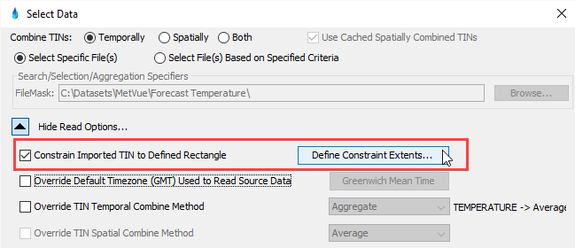
When reading data, HEC-MetVue provides an option to limit the spatial extent of data to be read. Providing a spatial extent constraint when reading data provides a means to trim data, thus reducing memory impacts and speeding up data loading/processing. Therefore it can be a very powerful tool when analyzing a region that is much smaller than the spatial extents of the available data. Specification of spatial extent constraints can be specified in both DSS and Non-DSS Data Selectors, by checking the "Constrain Imported TIN to Defined Rectangle" checkbox, and clicking the "Defined Constraint Extents" button highlighted below. This action will bring up the "Select Extent Read Constraints" window, which is described below.
Item
Description
1
This option allow for the specification of a Defined Rectangle (in Latitude and Longitude) for specifying the extents to be read.
2
This option allows for specification of a Polygon Mask (Shapefile) for defining the extents of the data to be read.
3
Definition of the Latitude/Longitude box defining read extents. If the data is not defined in a geographic coordinate system, the data extents will be the minimum extents that encompass the two points.
4
This will replace the Latitude and Longitude of the Defined Rectangle with the current view extents of the Map Window.
5
This will replace the Latitude and Longitude of the Defined Rectangle with the current view extents of the Loaded TIN data.
6
These options define how to interpret the selected polygons:
Extents: The minimum bounding box that encompasses the polygon.
Inclusive: Read all points that are within the polygon, or have TIN connections to points within the polygon.
Exclusive: Read all points that are within the polygon.
7
List of shapefiles that are used to define the extents read constraints.
8
This button adds all background maps, from the current Map Window, to the list of Shapefile Masks.
9
This button adds all basin average maps, from the current Map Window, to the list of Shapefile Masks.
10
This button allows for selecting files on the local computer to add to the list of Shapefile Masks.
11
This button will remove the selected Shapefile Mask(s).
12
This button saves the constraints.
13
Cancels any changes made. All edits are discarded.