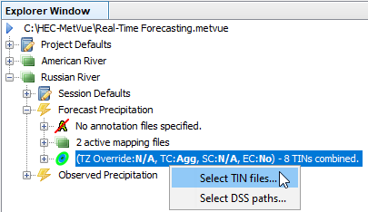
To select data from a file, right-click on the node in the Project Explorer window denoting the TINs selected for either the Project, Session, or Map Window of interest.
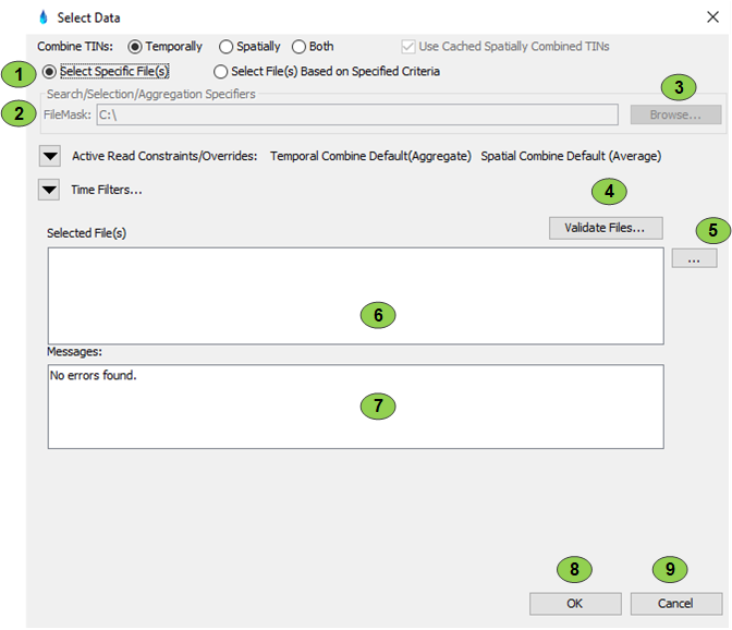
The Select TIN files option brings up the following dialog, the Non-DSS Data Selector.
When 'Select Specific Files' is selected, the File Mask selection (items 2 and 3) is disabled, the Time Filtering is ignored, and the buttons 4 and 5 are enabled to allow selection and validation of files. The text field (item 6) is also directly editable in this mode. Note that validating as shown in button 4 is a convenience to ascertain any unwanted overlaps that the data may have. Regardless of the warnings, the TINs can always be aggregated together when this is selected.
2
This filter restricts the list of potential files to the file mask selected. Normal search masks of '*' and '?' are supported.
3
This is used to select a file or directory to use for a file mask template so the entire directory location does not need to be typed. When using file masking, or selecting a directory, the Time Filtering can be used to constrain the data selected.
4
This button is enabled only if the 'Select Specific File(s)' option is selected. It inspects the metadata in the files and prints out warning for any issues with aggregating them.
5
This button is enabled only if the 'Select Specific File(s)' option is selected. It opens a standard file selection dialog where one or more files can be selected.
6
This shows the resultant files selected from the filename and time filtering. This field in not editable unless the 'Select Specific File(s)' option is selected. Note: for legacy reasons, this program will read image data directly from a text file but does not yet have facilities for specifying the timespan, image type, or data units for the data. It can be displayed.
7
Any warnings dealing with invalid images will be displayed here.
8
Accepts the selections made. If the selection is being made for a Map Window or a Map Window inherits these settings then the program starts a process (thread) to aggregate these images. If no Map Window (perhaps a session with no active Map Windows) currently uses these settings, then the information is stored until needed and no action is taken.
9
Cancels any changes made. All edits are discarded.