The Project Explorer was designed to provide quick access to many settings of the program, session and individual map components within the program. As stated earlier, a project can have many simultaneous sessions open with its descendant map windows. It is this hierarchical relationship of the program having many sessions and each of the sessions having possibly more than one map window that lends itself well to the Project Explorer window. The Project Explorer window can be a convenient way to navigate and establish settings for the various components.
The Project Explorer shows the relation between each of the individual components in the program as a set of descendant properties and objects. Typically, it is necessary to have a Properties Window open in conjunction with the Project Explorer window as both are almost always needed.
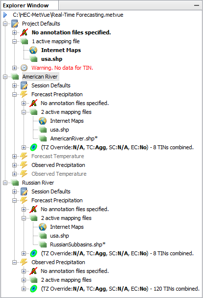
The top level node shows the name of the Project File being used. Following the Project node, there are 'Project Defaults'. These are items such as definitions of annotation files, shapefiles, basin average files, and TIN dataset definitions. When a new session is created it inherits settings from the Project Defaults.
Once a session (for example 'Russian River' shown below) is created, a set of 'Session Defaults' settings are created. Notice that some of the node descriptions in the figure below are in normal text, some are in bold text and some are grayed out. The nodes containing items that are not inherited, such as the "Project Defaults" shapefile (use.shp), is bold because it is the default for the project. Alternatively, the maps under the Map Window nodes are normal font, as they are inherited by the Project or Session (i.e. in Session: "Russian River", Map Window: "Forecast Precipitation", see the RussianSubbasins.shp node). Further, note that the "AmericanRiver.shp" and "RussianSubbasins.shp" nodes have an asterisk, indicating that these are basin average maps, whereas "usa.shp" has no asterisk, indicating this is a background map. Under the "American River" Session, the "Forecast Precipitation" and "Observed Precipitation" Map Windows are open, as indicated by the black text, but the the "Forecast Temperature" and "Observed Temperature" Map Windows are closed, as indicated by the gray text.