Download PDF
Download page Combining Data Options.
Combining Data Options
Process Overview
HEC-MetVue will combine multiple spatial datasets into a single image for the default visualization. When dealing with multiple spatial datasets, there are three scenarios to handle:
- Data has same spatial extents, but occurs at different times
- Data has different spatial extents, but occurs at the same time span
- Data is a mix of different spatial extents and different times
Combining Spatially Inconsistent Datasets
HEC-MetVue has special logic to handle the combination of a mixture of input TIN and gridded datasets, to create a composite TIN dataset for display and processing. The following examples illustrate when this would be necessary.
- Filling in missing time-steps in a set of grids with gage data.
- Spatially combining gridded data that have different projections.
In order to support these scenarios, HEC-MetVue will follow the set of rules below:
- Combining two or more TINs: Prior to combination, a TIN made up of the distinct [X, Y] points for all the images is created, and then the individual TINs are projected onto the aggregate TIN. Following this step, a consistent set of TINs is available, and can be combined temporally.
- Combining two or more gridded datasets: Prior to combination, each grid is inspected to identify the most resolute data (smallest grid size). Next, a minimum required spatial extent to cover all datasets is identified. Based on this resolution and spatial extent, a resultant grid is defined. Finally, all grids are projected onto the resultant grid, creating a spatially consistent set of grids that are combined temporally.
- Combining one or more TINs with one or more gridded datasets: This combination process is identical to combining two or more gridded datasets, with the exception that the TINs are not considered when identifying the resultant grid resolution. With that resultant grid, all TINs (gridded and irregular) are projected onto that resultant grid prior to combination.
Although HEC-MetVue is capable of combining a mixture of spatially inconsistent datasets, this requires additional computations to complete. Due to these added computations, loading spatially inconsistent datasets can be much slower than loading spatially consistent datasets.
Image Combine Options
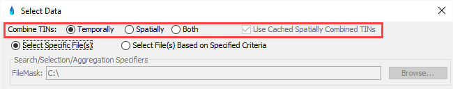
The image below highlights the selection options of Temporal, Spatial or Both for combining data. The "Temporally" combine option identifies that the images are expected to be images coincident in space but occur at different times. Alternatively, the "Spatially" combine option identifies when the images are expected to be images coincident in time but cover different spatial extents. Using the "Temporally" or "Spatially" combine options enable warnings when data is not as expected. For example, if the "Temporally" option is selected, but two images occur at the same time, then a corresponding warning will be provided. Alternatively, if the "Spatially" option is selected, but two images occur at different times, a corresponding warning will be provided. If data is expected to span multiple times and spatial extents, the "Both" option will allow for applying spatial combination when data is coincident in time and applying temporal combination when the points are coincident in space.
When the "Use Cached Spatially Combined TINs" box is checked, spatially combined TINs are cached to speed up data data processing. Cached TINs are kept in a DSS file in the temp directory in a work file named METVUE_WORK.DSS. MetVue creates a pathname based on the name (APART) of the TINs being aggregated and the latest time of modification of the TINs being combined for the time interval (BPART). If the TIN pathname exists in the DSS work file and the original TINs have not been modified, the cached TINs are used.
Temporal Combine Method Override
The image below highlights the ability to override the temporal combination method. By default, the temporal combination method is either Aggregate, or Average, depending on the data type. This is noted in the text to the right of the drop-down selection box. This method can be overridden with another method. For example, if the data is temperature, it will be averaged by default, but the user might be interested in the maximum value. The "UseMax" option can then be selected to see an image of maximum temperatures.

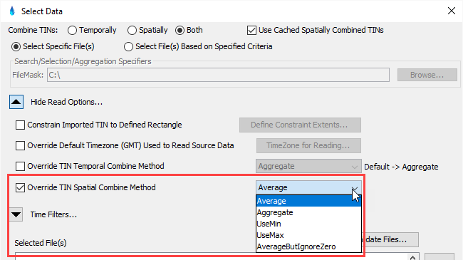
Spatial Combine Method Override
The image below highlights the ability to override the spatial combination method. By default, the spatial combination method Average. This method can be overridden with another method. The most likely method to override with is the "AverageButIgnoreZero" method. This method is useful when two images disagree, but one of the images is zero, and therefore may indicate a problem with the observation.