Dynamic Time Window Scanning requires special auto-processing of data to rapidly display data requested by the user. The first step in caching data is to save a copy of the TIN/Grid data in flat files within a temporary directory. Following the caching of the raw TIN/Grid data, information is cached for the Polygon Average Layer.
TIN/Grid cache files will be placed at %TEMP%/MetvueCache/Session_MapWindow. These files are labeled as the data start time (in milliseconds since 1970), and the tile number is appended for raster data. Tiling of raster data improves efficiency when saving/loading datasets with a large number of points. Along with these files is a header that describes the spatial domain of the data. In order to maximize efficiency, data is stored in its native resolution, and any images that are spatially inconsistent are forced onto a consistent set of points following the AddTin merge rules.
Following the caching of the raw TIN/Grid data, information is cached for the Polygon Average Layer. Polygon Average Layer information is cached into two files: a time series file and a polygon file, both of which reside in the %TEMP%/MetvueCache/Session_MapWindow directory.
All files in the MetVueCache directory are removed during normal shutdown of the program. In the event that the program does not successfully remove these cache files on close (i.e. the program was interrupted unexpectedly), the user can delete all files in %TEMP%/MetvueCache without consequence.
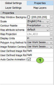
Caching of data to the temporary directory occurs when loading the data. If auto-caching is enabled, the data is cached on the initial load of the data into the Map Window node. By default, the cached data is not created until the animation is enabled, and therefore requires a reload of the data when the animation is enabled. In order to cache data on initial load, the user is required to select the "Auto Cache Animation" checkbox, shown in the image below. When this setting is selected, the data will be cached when data is loaded, and therefore the data will not need to be reloaded when the animation is enabled.

Once the data is cached and the Dynamic Time Window Scanning Toolbar is enabled, preparations for image rendering begins for Rasters. For Contour and Polygon Average layers, the values are loaded from disk, combined temporally, interpolated spatially, and displayed on every change to the viewed time window. Given the relatively small number of points when viewing irregularly spaced data, and small number of polygons, rendering is typically fast enough to occur on user interaction with the time window. Alternatively, Rasters often have a very large number of points, requiring a more sophisticated approach to rendering. For more information, see Image caching with Raster Data.