Attribute Guide
The National Structure Inventory (NSI) Survey Tool is designed to collect information on structures through user input. The input is intended to serve as the basis of quality assurance and quality control for the NSI and to help improve the dataset with time by providing evidence to support the refinement of assumptions for various attributes in the NSI.
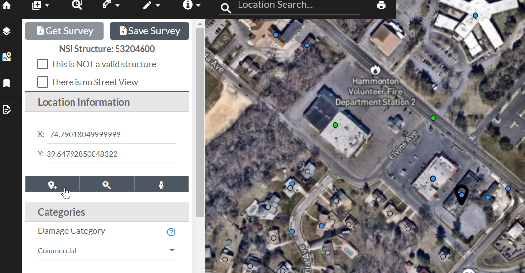
The tool operates off of locations (x and y values) that correspond with current NSI locations. The Survey Tool allows for structures to be specified as a control group that all surveyors (users) of the tool must input. These control surveys help to evaluate bias in surveyors.
The Attribute Guide presented below is provided as suggested best practices. This guide was created to support a nationwide survey completed by the NSI Development Team. However, each user's needs may differ.
Opening the Survey Tray
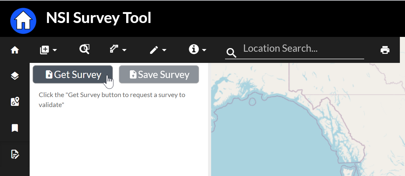
The purpose of the NSI survey tool is to allow a user to define characteristics about a structure provided by the survey tool. The first step to getting an assigned structure is to open the survey tray. The survey tray tool is on the left sidebar tool bar and looks like a piece of paper with a pencil.

Once the tray is open the user can select "Get Survey" to be provided a new survey.
Changing the Base Map
It is very helpful to have multiple base map views available for use in the NSI Survey Tool. In order to change the NSI Survey Tool Base Map select the Base Maps tool in the Left Sidebar tool bar.
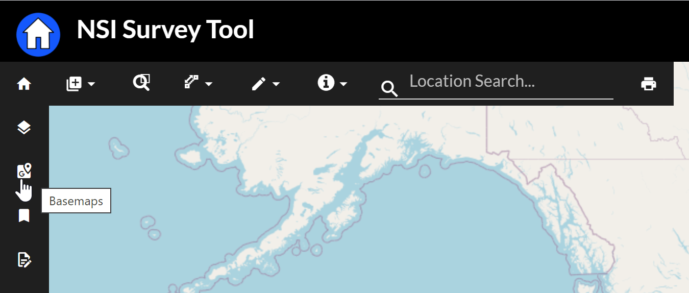
This will present the user with many options for background imagery.

Select the appropriate background layer for your needs and then close the Base Layer selection tray by clicking on the base maps tool again.
Damage Categories
Damage category is populated by default to provide context in the case the location of the structure is near multiple structures. Evaluate the Damage Category based on what you see in street view or imagery.
| Name | Description |
|---|---|
| Residential | Homes, single family through multi family categories |
| Commercial | Commercial facilities provide access to goods and services |
| Industrial | Industrial facilities are used to produce goods |
| Public | Schools, public offices, churches |
Occupancy Types
The occupancy type field is populated by default to provide context in case the location of the structure is near multiple structures. Evaluate the structure based on what you see in street view or imagery.
An occupancy type is a way to categorize structures based on similar or shared characteristics. NSI occupancy types are based on the Hazus conventions. The Occupancy type is a further revision of Damage category and should be in agreement. Occupancy type influences assumptions of number of residence, damage relationship assignments, and day and night time.
| Occupancy Type | Description |
|---|---|
| RES1 | Single Family Residential Structures |
| RES2 | Mobile Home |
| RES3-AB | Multi-Family Housing 2-4 units |
| RES3-CD | Multi-Family Housing 5-20 units |
| RES3-EF | Multi-Family Housing 21-50 units |
| RES4 | Hotel or Motel |
| RES5 | Institutional Dormitory |
| RES6 | Nursing Home |
COM1 | Retail |
| COM2 | Wholesale |
| COM3 | Personal and Repair Services |
| COM4 | Professional or Technical Services |
| COM5 | Bank |
| COM6 | Hospital |
| COM7 | Medical Office |
| COM8 | Entertainment or Recreational |
| COM9 | Theater |
| COM10 | Garage |
| IND1 | Heavy Industrial |
| IND2 | Light Industrial |
IND3 | Food, Drug or Chemical Processing |
| IND4 | Metals or Minerals Processing |
| IND5 | High Technology |
| IND6 | Construction |
| AGR1 | Agriculture Buildings |
| REL1 | Church |
| GOV1 | Government Services |
| GOV2 | Emergency Response Services |
| EDU1 | School |
| EDU2 | College, University |
- Most structure occupancy type identification can be done with the NSI survey tool if it has ground-level images of structures
- If not, Google Maps/Earth with Street View (if available) are the best tools
- Many occupancy types are straight-forward and obvious
- For residential areas, similar occupancy types tend to be grouped together
- Example: A neighborhood of RES1 structures will not often many other occupancy types mixed into it. If they do, it’s usually easy to spot.
- For the not-so-obvious structures, choose the occupancy type that most-closely resembles the surveyed structure
Workflow
- Step 1: Determine if the surveyed structure falls into the residential, commercial, industrial, or public/government category?
- Step 2: Look at additional features of the surveyed structure to assign an occupancy type
- Example: For residential structures…is it a single-family dwelling? Is it a multi-family dwelling? Is it a modular home?
- Example: For commercial…what kind of business is it? Does it obviously fit into one of the COM occupancy types? If not, which is the closest occupancy type that matches the surveyed structure?
- Example: For industrial…what is being produced? What kind of equipment is there?
- Example: For public…is it a government building? Is it a religious building? Is it an education building?
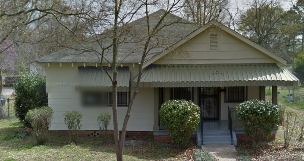
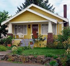
RES1

RES2

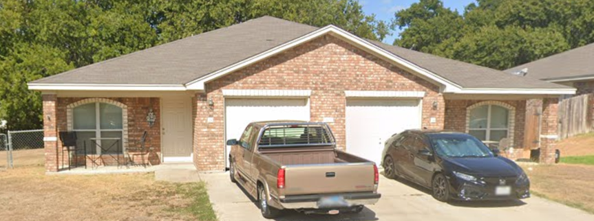
COM1

IND1

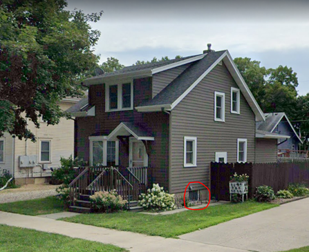
Foundation Height
The foundation height should measure the height from the ground to the first residing floor.
The first residing floor is important to determine, especially for buildings like raised ranches or split levels (indicated below).
Analyzing Standard Foundation Heights
If the building appears to be at ground level, and there are no stairs to reach the first residing floor, the foundation height is likely close to 0 feet.

Using Stairs to estimate Foundation Height
Usually, the easiest way to measure foundation height above 0 feet is to count the stairs, assuming each step is close to 0.5 feet (ex. if a house has 4 steps for first floor, 0.5 x 4 = 2ft foundation height). If steps appear to be out of code and significantly steeper than 6 inches, it may be necessary to deviate from this general rule.
If the building is on piers with a garage/carport under, the foundation height may be approximately 8-10 feet.
Analyzing Non-Residential Buildings
Many non-residential buildings will have a foundation height of 0-1 feet. When analyzing street-side commercial buildings in a major city, use a foundation height of 0.25-0.5 feet to account for the nearby curb or threshold. The below Table provides standard heights for common items that can be used as a reference.


Analysis Workflow
First, determine the first residing floor of a building.
Second determine how to analyze the foundation height. Most buildings should be near ground level or measured using stairs. Otherwise, use best judgement. It may be helpful to use nearby surroundings as a reference, such as a vehicle in the driveway, or a person within the street view image.
| Reference item | Height (ft) |
|---|---|
| Stairs | 0.5 - 0.65 ft per step |
| Garage | 8-10 ft |
| Sedan | 4.5 ft |
| SUV/Truck/Minivan | ~6.0 ft |
| Adult Person | ~5.0 - 6.25 ft |
Finally, use the reference evidence to estimate the foundation height.
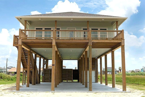
The image above is an example of how to use best judgement to determine the foundation height. The "garage" identified in the back is about half of the foundation height. Assuming a height of 7- 8ft, the foundation height should be about 15 ft.
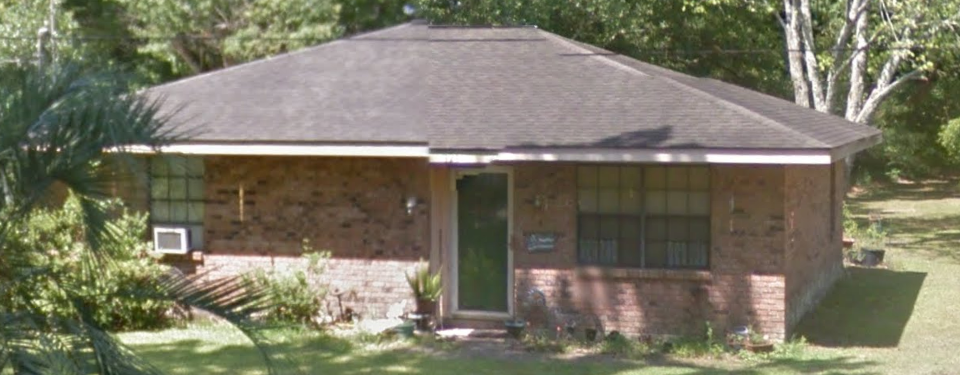
Foundation Type
Foundation types are important drivers for damage. Adding basement can significantly change the damage function. Not correctly identifying Piers in coastal environments can have significant impacts on the damage functions. This information is often not discernable from Street View images, but can be reasonably assumed with some confidence.
There are ten options for foundation type: pile, pier, solid wall, crawlspace, continuous footing, enclosed or partially enclosed pier, basement, or mat.
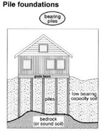
Pile
Distinguishing features, Uneven Ground, support beams around he foundation, more likely in areas near the coast or with terrain variations.
Pier


Enclosed or Partially Enclosed Pier


Crawlspace


Basement

Slab


Invalid Structures
The locations of the surveys can occasionally fall in locations that are not near any structures. If there are no structures, or if there is a point and all other structures around already have points located on their rooftops it is acceptable to identify the structure as Invalid with the "Structure is Invalid" check box. In those cases, it is not necessary to fill out any fields for the "structure."
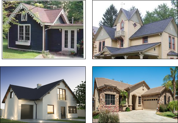
Construction Type
SFR Types
There are four different Single Family Residences that account for the original construction cost of the structure. In order of least expensive to most expensive, they include Economy, Average, Custom, and Luxury.
Most RES1s should be mapped to one of these four types. More counter-intuitively, some small RES3s may also be mapped to a SFR Replacement type if they appear to be duplexes converted from a SFR.
There is no established objective standard for the distinction between Economy and Luxury. However, attributes that indicate high potential reconstruction costs may warrant deviating from "Average" to either custom or Luxury. Meanwhile, poor original construction costs, simple features, and the use of shared/attached walls between housing units may justify the use of "Economy" or downgrading the type from a higher level.
Several examples are provided below. These are primarily "control" structures from the nationwide survey that the majority of surveyors identified fairly consistently (but not always unanimously) as the indicated type. In cases were surveyors were largely split, both categories that surveyors were split upon are shown.
Economy


Average


Average/Custom

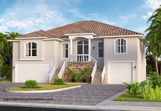
Custom:


Custom / Luxury:


Luxury:


Non-SFR Types
There are numerous non-SFR Replacement Types. RES2s should generally be mapped to "Manufactured" and most large RES3s can safely be mapped to "Apartment."
Non-residential structures have many more options, with multiple variations, of garages, stores, restaurants, schools etc. Replacement types are often linked to a particular OccType such as COM6 mapping to "Hospitals", however, other Occupancy Types such as COM1 or GOV1 may map to multiple Replacement types and surveyors should use their best judgment along with clues such as business names and Street View imagery when assigning these categories.
Quality
The quality field represents the degree to which the structure has deteriorated or depreciated since its initial construction. There are three levels to the field, Below Average, Average, and Like New. These fields are distinct from the RS Means SFR Types (Economy, Luxury, etc); while the fields may (or may not) be correlated, there can still be Dilapidated Luxury structures and Like New Economy structures.
Below Average
"Below Average" represents circumstance where the structure has significantly depreciated due to visible signs of distress. For instance, damage to the roof and busted or boarded up windows may be indicators that routine maintenance has been deferred and that the structure would need significant investment to return it to the quality of its initial construction.


Average
"Average" represents the most common level of quality. The structures may have been built 5 to 100 years ago, regardless, the owners appear to have not deferred essential maintenance. While there may be signs of chipped paint or dirty exteriors, there is no significant structural damage.


Like New
"Like new" represents structures a quality that is likely associated with either newly constructed structures, or, structures that have recently received significant investment to return them a condition similar to a newly constructed structure. There should be little to no indication of outstanding maintenance.


Exterior Construction
We have seven possible inputs for exterior construction. The exterior construction reflects what is added to the exterior, not how the frame is constructed.
- Wood
- Brick
- Manufactured
- Masonry or Concrete
- Steel
- Other
- Unknown
Wood frame houses
Many residential houses you will review will be wood frame houses. Public/Industrial buildings are less likely to be wood. Wood comes in a variety of forms and is often covered in vinyl or veneer. Wood is less resilient than brick or masonry.


Brick Houses
Bricks are often more resilient and more expensive. In the case of partial brick facades, it is recommended that surveyors select the predominate type (often "Wood").
Best Judgement:
• Look for header rows and multiple walls of bricks.
• Brick houses tend to be older/show signs of wear or more obviously completely brick.
• Veneer is meant to look “pretty”.


Stucco Note: -Exterior coating and not what the structure is made of.


Steel Exterior - Warehouses/Industrial
• Generally industrial/commercial
• Small percentage of inventory

Masonry
• Concrete, more resilient than brick.
• Often supported by a steel frame.
• Can be covered in Stucco
• Popular with Public Buildings


Other/Unknown
Glass, Manufactured, Unidentifiable


Number of Stories
This field indicates the number of floors within the structure that persons or property may be located. This does not, however, include basements.
This field should generally be a fairly simple process of counting windows, however, there will be many exceptions. The number of stories, when multiplied against the estimated occupied square feet should generally equal the true above ground square feet of the structure. Toward that purpose, the use of decimals may be appropriate in instances where a built in garage occupies much of the first level or if a second floor only covers a portion of the first floor.
When rounded up, the number of stories should also be a fair representation of the ability of residents to vertically evacuate. For instance, even if a built-in garage occupies much of the first floor so that the number of stories is 1.25, this value may be rounded up to "2" to acknowledge that Population-at-risk may evacuate to a second story if necessary.
Irregularly shaped commercial buildings may necessitate a judgement call by the surveyor. If a tower portion of the structure is significantly wider than a base section, surveyors should do their best to accurately portray the structure's characteristics. In most cases, surveyors should report the true number of floors and consider modifying the "occupied square feet" estimate to be tailored toward the main portion of the structure so that a reasonably accurate final square footage estimate may be obtained.

Occupied Square Feet
Survey field definition: The livable area of the broadest level of the structure, excluding patios, garages, etc. from the building footprints.
Use polygon tool to line the perimeter and estimate square footage of the widest floor. Square footage is necessary when estimating structure value and is used indirectly to estimate content value at the structure. Will be multiplied against Number of Stories later to obtain true square footage.
Detached Garage Example

Small Front Porch Example

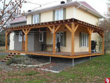
Large Wrap Around Porch Example

Mother In Law House Example

Workflow Recommendation
During the survey process, once you determine that the occupancy type is residential (not commercial or other)
This information will help identify the livable area of the house:
- Aerial images to identify additional features of the house (sheds, garages and mother-in-law suites etc.)
- Street view to determine if there is a porch, the entire porch should be excluded. Both visible porches and extension of the roof section will help identify this feature.
- Street view to determine what the structures are, sheds and garages will be excluded like porches.
Measure Tool from CM3
To make evaluation of the occupied square feet easier, we have provided a measure tool through the CorpsMap plugins. To use the measure tool...


double click on the last point to close the measure session.

and paste the value into the SqFt Field.
XY
The initial X/Y location of the sampled structure may not represent a true structure location, or it may represent the location of a structure of a different structure type.
In the later case, surveyors may simply change the Occupancy Type to the correct classification.
Surveyors may update the x/y location by first clicking the "Get location..." button, which features a marker with a smaller plus symbol. Their cursor will then change into a plus symbol until they click on a new location. Doing so will move the sampled structure's marker to the new location and change the x/y values featured in the form.

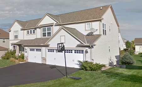
Garage
There are 10 different types of garages offered in the NSI Survey tool the options are combinations of one through three cars attached, detached, or built in.
Attached Garages


Detached Garages


Built In Garages
Built in garages refer to garage configurations with living space above the garage.

No Garage

Garage Configurations and Tandem Garages


Roof Style
There are nine options for roof type Gable and Hip with and without valleys (if there is a hip, choose hip even if there are other gables). Mono Pitched, Offset Mono pitched, Flat and Gambrel
Gabel
A gabled roof consists of two roof sections sloping in opposite direction that meet in the middle to form the highest ridge
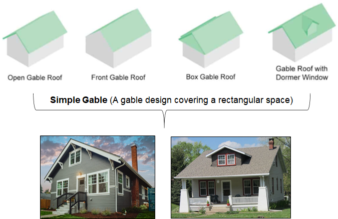

Gabel with Valley

Hipped Roof
A hip roof slopes up on all sides, a hip is where the three (or four) slopes intersect together.


Hipped Roof with Valley


Mono Pitched Roof and Offset Mono-Pitched Roof


Flat Roof

Gambrel-Style Roof

