Download PDF
Download page Export Channel Data for Terrain.
Export Channel Data for Terrain
RAS Mapper provides the capability to export channel (bathymetric) from an existing HEC-RAS Geometry to merge with other ground surface information in the Terrain Layer. This improves the visualization of computed water surface inundation extents and depths. Further, it allows the user to "cut" new cross sections at additional locations.
How does it work?
Prior to creating the channel surface, you should understand the process RAS uses to create the data. The channel surface gets the elevation data from the Cross Sections and will then be interpolated from cross section to cross section using the shape of the River Centerline, Bank Lines and Edge Lines. The Bank Lines will control the limit of the "channel" export, while the Edge Lines control the bounds of the interpolation. The results of the interpolation using the Cross Sections, River, Bank Lines, and Edge Lines can be visualized and inspected by the Interpolation Surface.

The channel Bank Lines control how interpolation is performed. Make sure they do not cross each other or the River Centerline.
Step-by-step guide
To export the channel bathymetric data within RAS Mapper, perform the following steps listed below.
- Begin Editing the Geometry of interest.
- Right-click on the Bank Lines Layer and select Compute Bank Lines from XS Bank Stations.
- Inspect the Bank Lines
- Adjust the Bank Lines as needed to properly capture the channel
- Right-click on the Interpolation Surface Layer and select Compute Interpolation Surface.
- Right-click on the Geometry and select Export Layer | Create Terrain GeoTiff from XS's (Channel Only).
- Provide a layer name for the new GeoTiff.
- Provide a rasterization cell size for the new GeoTiff.
To merge the channel GeoTiff with an existing ground surface model, perform the following steps listed below.
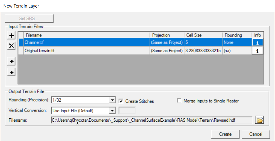
- Right-click on the Terrains group and select Create a New RAS Terrain.
- Add the terrain models of interest.
- Prioritize the terrain models, making sure the "channel" surface is on top.
- Enter a unique name for the Terrain Layer.
- Press the Create button.
Common Problems
The results of the channel surface are dependent on the cross sections and bank line information. Because HEC-RAS allows users to store the geospatial "cut line" information separate from the station-elevation data, users might not get the surface they are expecting. The best way to identify problems that will occur with final channel surface is to inspect the Bank Lines Layers.
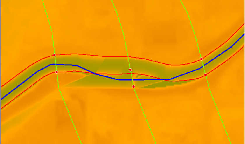
Below is an example demonstration problems with a channel surface that is created where the geospatial portion of the cross section differs from the station-elevation data. In the figure below, it is clear that the interpolation between the cross sections went poorly in RAS Mapper. Investigation of the interpolation surface showed no problems.

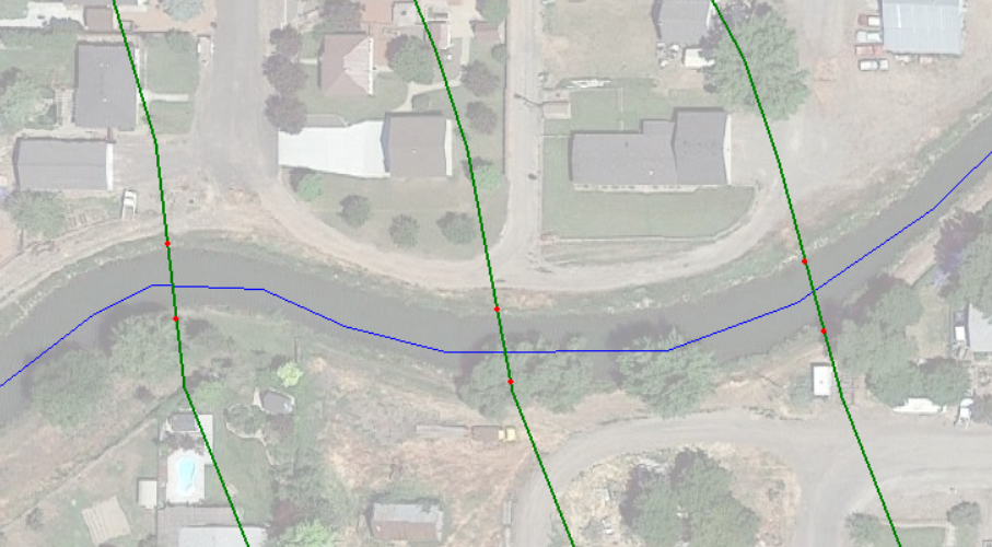
Right-click on the Bank Lines Layer and select Compute Bank Lines from XS Bank Stations (while Editing the geometry in RAS Mapper). Inspect the cross sections, river centerline, and bank lines together - there is an issue with the bank lines and bank stations. In RAS Mapper, the Bank Stations are created based on the length of the Station-Elevation data. The Bank Lines, however, were generated based on the geospatial length of the cross section. (We currently don't have a solution for this data problem in RAS Mapper, so we need to fix it over in the Geometric Schematic.)
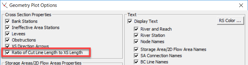
Close RAS Mapper and open the Geometric Schematic. Go to the View | View Options dialog and turn on the Ratio of Cut Line Length to XS Length property.
The computed ratio of the geospatial portion of the cross section and the station-elevation data will be displayed at the start of the cross section (left side) as shown in the figure below.
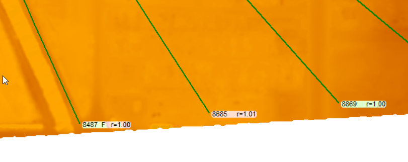
If the ratio (r) is greater than 1.0, the geospatial portion of the line is longer than the station-elevation data and the cut line should be shortened. If the ratio is less than 1.0 the geospatial portion of the line is shorter than the station-elevation data and should be lengthened.
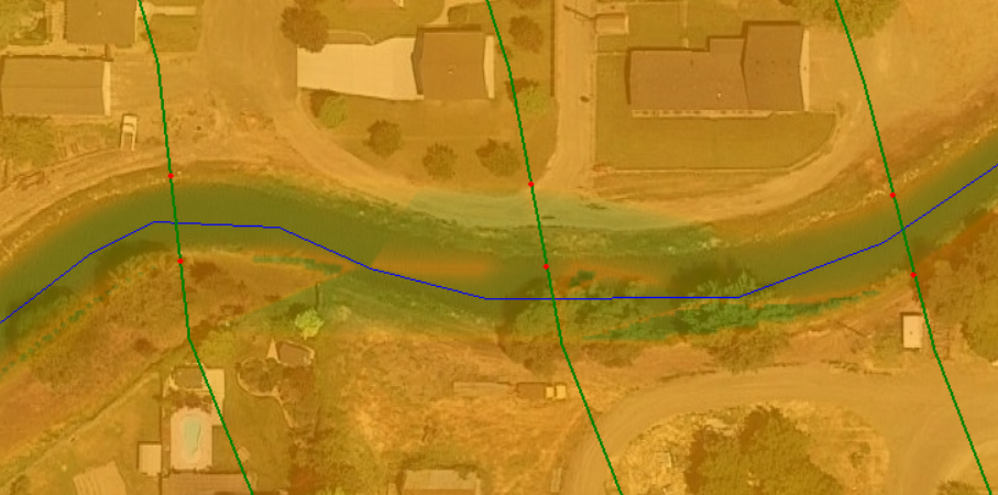
Because r=1.01, we have identified that the cut line length is too long, given the station elevation data. So how do we fix it? Based on the figure above (where the bank lines don't match the bank station information, we see that the bank lines are shifted too far "to the right" because the geospatial line length is too long. We can double check this information using background imagery. In the figure below, you can see the back station are indeed shifted off the channel into the right overbank. This means we need to shorten the geospatial line length, taking it away from the end.
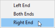
To shorten an cut line from the end, in the Geometric Schematic, left-click on the cross section and choose Adjust Cut Line Length to Match Sta/Elev > Right End.

(There is currently a replotting bug in HEC-RAS. So Save the geometry and then reopen it.) You will see the cut line changed and (likely) the bank stations will be in the correct location.
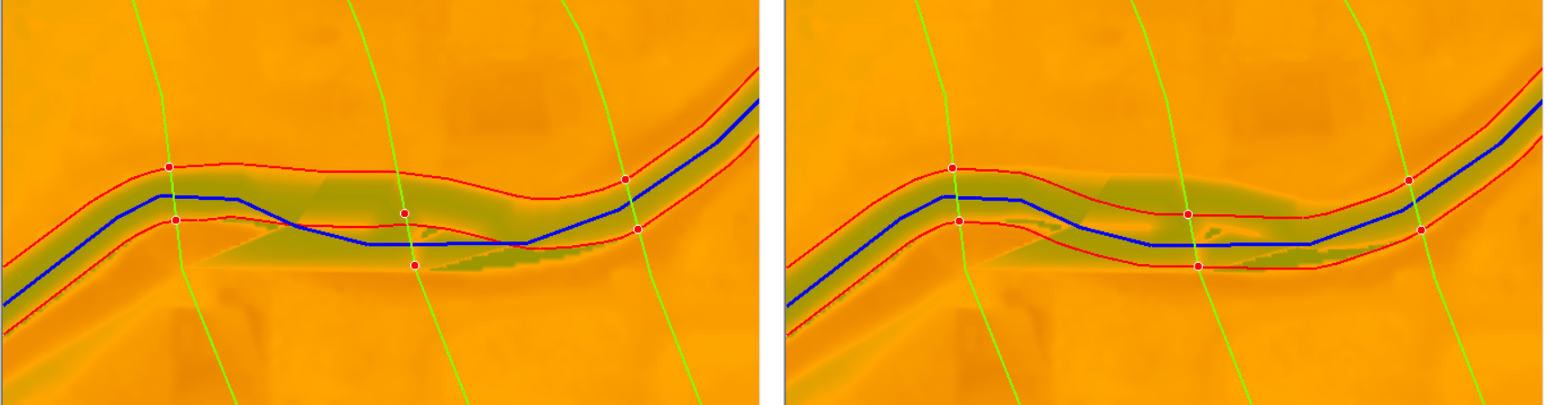
Now you can go back to RAS Mapper and perform the data export. Begin editing the geometry and Compute Bank Lines from XS Bank Stations. The original banks lines and new bank lines are shown in the figure below.
Inspect the bank lines, et. al and Compute Interpolation Surface and Stop Editing. Right-click on the Geometry and select Export Layer | Create Terrain GeoTiff from XS's (Channel Only).
Next, merge the channel GeoTiff with an existing ground surface model by right-clicking on the Terrains group and select Create a New RAS Terrain. Add and Prioritize the terrain models.
Enjoy the fruits of your labor with a new terrain model that has channel information included.
