Download PDF
Download page Floodway Workshop.
Floodway Workshop

Introduction
This workshop will help students learn how to use HEC-RAS to: perform a floodway analysis; and review and understand floodway output.
Background
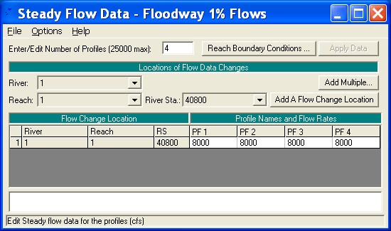
The study is a single reach composed of 9 cross sections and a bridge. The upstream river station is 40800 and the downstream river station is 29900. The bridge is located at river station 36975. The floodway will be based on a 1% Chance Flood of 8,000 cfs.
Problem Description
A project file (wrk6.prj) with the title “Floodway Workshop - Buffalo Ck.” has been loaded on your workshop computers. This file contains all of the data for this workshop, except the floodway information. A preliminary determination of the designated floodway for North Buffalo Creek is to be made for this reach of the creek. The objective is to establish the maximum limits of encroachment using the following guidelines:
- Water surface elevations should not increase over one-foot above the base profile.
- The channel velocity should not increase to the point where damage might be inflicted beyond base conditions.
- The top width of the floodway should not vary to the extent that it would be difficult to establish the floodway limits in the field.
- Encroachments are to be determined on all bridges.
Problem
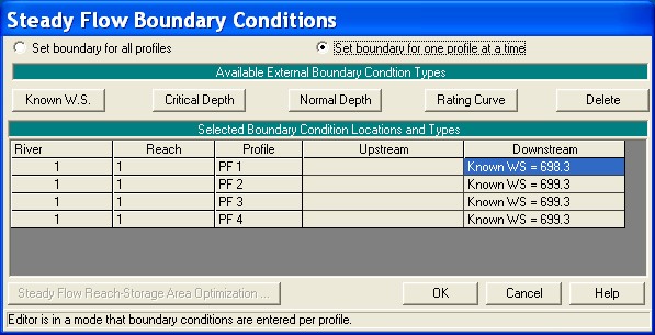
Using the provided Buffalo Creek data set, make a preliminary floodway determination with several levels of Method 4 and/or 5. Start the base profile with an elevation of 698.3 and begin encroachment profiles with an elevation of 699.3.
- Do any of the initial floodway runs meet the criteria? If not, use multiple targets in a combined floodway run. Methods and targets can be changed at any section.
- Can you obtain a floodway within the one-foot rise? What is the minimum rise? What seems to control the minimum increase?
Floodway Trial 1
First, the number of profiles must be set for the floodway run. At least two are required. For the initial runs, four profiles were used. Also, the starting water surface elevations must be set for the profiles.
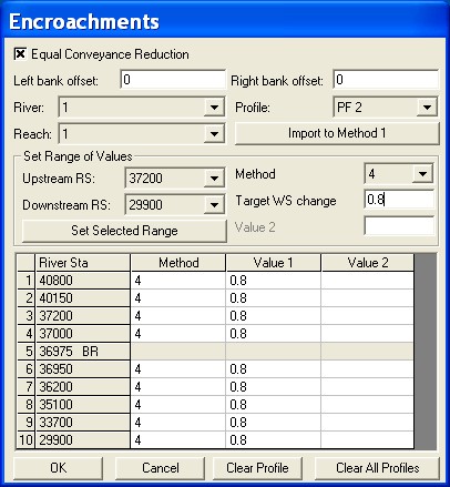
After the flow-profiles are set, the Encroachment data are entered under Options, then Encroachments in the Steady Flow Editor.
The first trial was set to compute Method 4 with 0.8 and 1.0 foot rise, and Method 5 with a 1.0 foot rise on water surface and energy elevation. The figure below shows the Encroachment Editor for the Method 4 input. The data are entered for profiles 2 through 4.
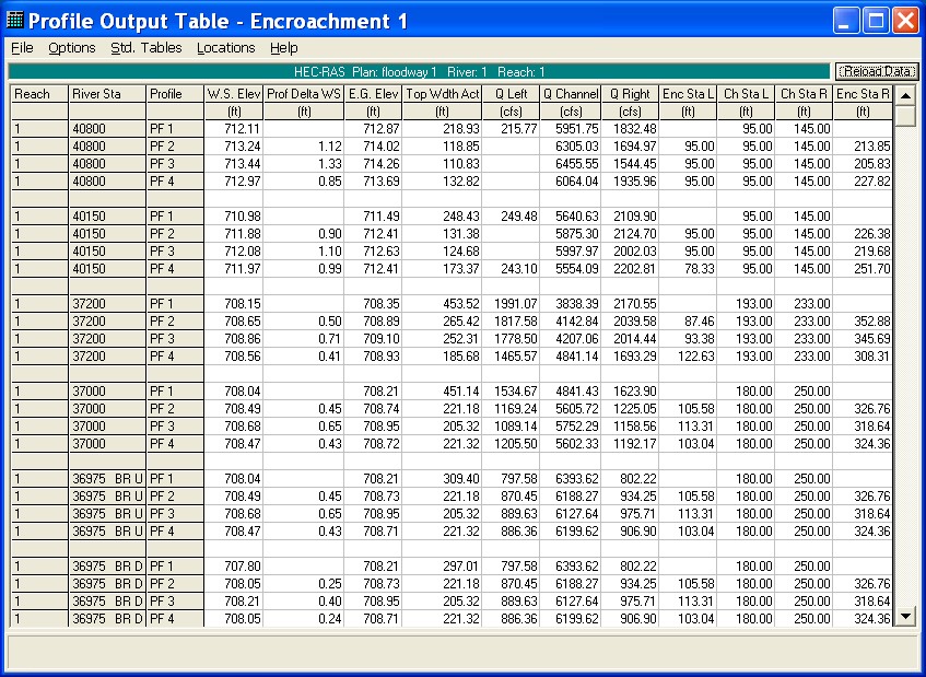
The Floodway Summary Table 1 shows the first trial results. (The cross-section order was switched to downstream to upstream to review the results from the downstream order.) None of the floodway profiles met the specified criteria. The two best profiles were the second, Method 4 with 0.8-foot rise, and profile 4, Method 5 with a 1.0-foot water surface and energy elevation target. It is clear that the bridge sections will alter the rise in upstream water surface elevation, especially with weir flow conditions.

Floodway Trial 2.
The computed encroachment stations from any profile can be easily transferred as Method 1 data. Because Profile 4 (method 5 with 1.0 foot rise for water surface and energy grade) has the best overall result, those encroachments were converted to method 1 for application on a second simulation. Upstream from the bridge the rise in water surface elevation is below the target (1.00 foot) at sections closest to the bridge, but this occurs because the bridge is in a weir flow condition. Experience with this reach of stream has shown that encroaching slightly more than the method 5 at these sections will cause the last two sections (40150 and 40800) to rise greater than one foot. Therefore the results of method 5 encroachment (profile 4) were used with only minor adjustment. The Floodway Summary Table below shows the model result.
The results can be displayed on an XYZ Graphic to better see the floodway. As shown on the next page, the floodway seems to swing in and out with undulating top widths. These results can be plotted on the plan map based on the distances shown in the table above. A third trial may be appropriate to define the floodway more consistent with the curvature of the stream. Also, the computed results must be considered preliminary until it is coordinated with State and community officials. Where the floodplain is entirely contained within one community, the location of the floodway is negotiable and should be coordinated.@ (FEMA 37).

