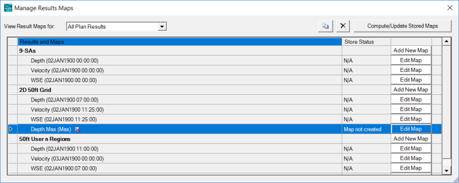
The user can create a static map (map stored to the disk) at any time from RAS Mapper by right clicking on Results | Manage Result Maps menu item. When this option is selected the window shown in Figure 6-10 will appear.

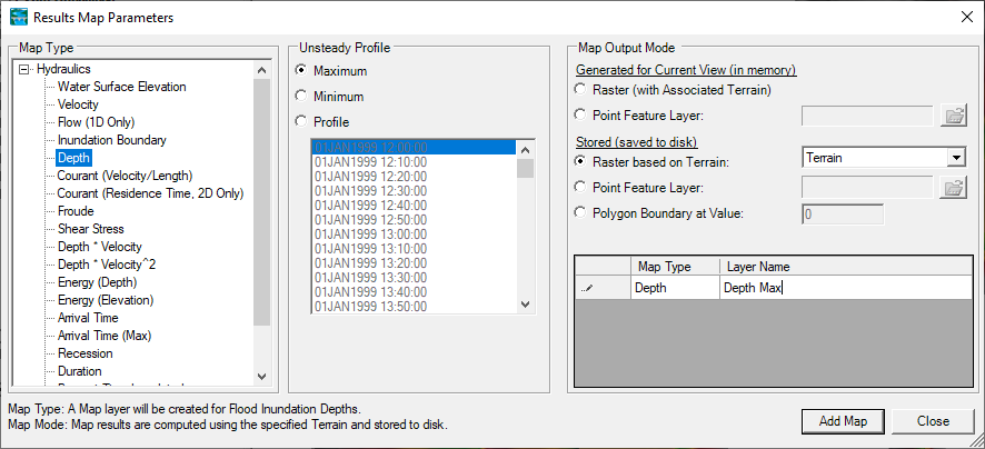
As shown in Figure 6-10, this editor will allow the user to create new map layers (Add New Map), as well as generate stored maps to a file (which can be used with HEC-FIA, or in a GIS, etc…). To add a new results map layer, press the button labeled Add New Map… for the desired Plan that the user wants to create a map from, this will bring up the window shown in Figure 6-11.

This window was described earlier under the section called Adding Results Map Layers for Visualization. This window can be used to create a Dynamic Map Layer, or create a Static Map by checking on one of the options under the Stored (saved to disk) section, then pressing the Add Map button at the bottom of the window (Figure 6-11). A new Layer will then show up on the Manage Results Maps window for the selected Plan, however, the status of that map will be labeled "Map files are out of date", which means the stored map has not been created yet.
To create the stored map, first highlight the layer(s) to be created, then press the button labeled Compute/Update Stored Maps in the upper right corner (Figure 6-10). This will start the process of creating/updating stored maps for all of the stored map layers that are out of date (only layers that are highlighted will be created/updated). When this process is complete, there will be a subdirectory within the project directory that is labeled the same name as the RAS Plan Short ID. This folder will contain the results in a gridded file format. RAS Mapper creates files in the GeoTIFF (Geospatial Tiff with .tif file extension) file format. The GeoTIFF is a file standard and can be used directly in ArcGIS 10 and higher and other software packages. The user can simply drag and drop the GeoTIFF files onto an ArcGIS project. The latest version of HEC-FIA (version 3.0 and above) also uses the GeoTIFF file format for incorporating HEC-RAS results for the computation of flood damages and potential life loss. Additionally RAS Mapper creates a file with the extension ".hdf" (HDF5 file). The .hdf file contains information for RAS Mapper about the GeoTIFF files. RAS Mapper also creates an XML file with the extension ".vrt". The .vrt file is supported by other GIS software for visualizing raster files. If the user has more than one terrain grid for the Terrain model, then RAS Mapper will also make more than one output depth grid. (i.e. it tiles them). The .vrt file is just a collection file that describes the other files and where they live spatially. If the user drags that file over to a GIS, or import it, then it brings in all the tiles as a single collection in one layer, and the user can have them all attributed the same.