Download PDF
Download page Importing Geometric Data.
Importing Geometric Data
HEC-RAS has the ability to import geometric data in several different formats. These formats include: a GIS format (developed at HEC); the USACE Standard Surveyor format; HEC-2 data format; HEC-RAS data format; UNET geometric data format; and the MIKE11 cross section data format. Data can be imported into an existing HEC-RAS geometry file or for a completely new geometry file. Multiple data files can be imported into the same geometric data file on a reach-by-reach basis.
Supported File Formats
GIS Format
A file format for interfacing HEC-RAS with GIS/CADD systems has been developed at HEC. A detailed description of the file format is contained in Appendix B of this manual. Chapter 14 of this manual provides detailed discussions on how to import GIS/CADD data into HEC-RAS, as well as how to export computed water surface profiles back to GIS/CADD systems.
USACE Survey Data Format
The U.S. Army Corps of Engineers (USACE) has developed a standard file format for survey data. This format is documented in Chapter 6 of Engineering Manual (EM) 1110-1-1005. The USACE survey format encompasses a wide range of data types. The current version of HEC-RAS has the capability to read this file format, but only cross section data are extracted from the file. At this time all other data are ignored.
HEC-2 Data Format
The HEC-2 program was the predecessor to the HEC-RAS software package. The HEC-2 program was used for many years to compute steady flow water surface profiles. Consequently, thousands of data sets exist in the HEC-2 data format. HEC-RAS has two ways of importing HEC-2 data. The first way is accomplished through the use of the Import HEC-2 Data option from the File menu on the main HEC-RAS window. When this method is used, it is assumed that the user has started a new project; and therefore all of the HEC-2 data is imported (geometric data, flow data, and plan information). A second way of importing HEC-2 data is provided from the geometric data editor. This way of importing HEC-2 data allows the user to bring the data into existing HEC-RAS geometric data files. This method also allows the user to import multiple HEC-2 data files into the same HEC-RAS geometric data file. However, when importing HEC-2 data from the geometric data window, only the geometric data contained in the HEC-2 files will be imported. All of the other data (flow data and plan information) will be ignored.
HEC-RAS Format
This option allows the user to combine several HEC-RAS geometry files into a single geometry file. For example, if several pieces of a river system were developed as separate HEC-RAS models, this option could be used to put them together into one model.
UNET Geometric Data Format
This option allows the user to import a UNET geometric data file (CSECT geometry file). UNET is an unsteady flow program developed by Dr. Robert Barkau. The Corps, as well as many other agencies, has used this software for many years. UNET models are often very complex, consisting of many river reaches that can be connected in numerous ways. The HEC-RAS UNET importer does not have enough information to draw the schematic in the proper manner. The river reaches and storage areas will be connected correctly, but the user will need to edit the schematic to make it look like the actual river system.
MIKE11 Cross-Section Data
This option allows the user to import cross section data from the MIKE11 program. MIKE11 is a one-dimensional river hydraulics model developed by the Danish Hydraulic Institute. Users must first export the MIKE11 data to a raw text file. This is an available option from MIKE11. Once the data is in the text file format, it can be imported into HEC-RAS.
CSV (Comma Separate Value) Format
This option allows for the import of comma separated value data. It is only intended to import cross section geometry and does not resolve the river network. River system connectively must be completed by forming junctions after all of the cross section data has been imported.
The data must be in the format of "River Station", "X", "Y", "Z" or "River Station", "Station", "Elevation", as shown in Figure 5-83. Once a file has been selected, you must choose the file format and select the Column Headers that correspond to the HEC-RAS geometry convention. By default, HEC-RAS looks for keywords (such as "River", "Reach", "X", "Y", "Z", "Elevation", etc…) to automatically populate the selected data list item. The River and Reach data is optional – if it is not specified, all cross sections will be assigned to the same river reach.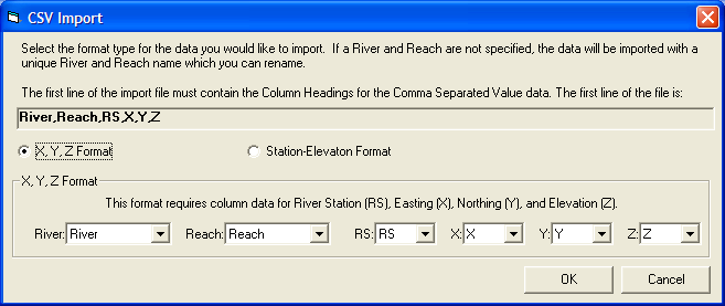
Figure 5 83. CSV data import window.
After identifying the Column Headers, using the dropdown lists, for the data in the CSV file, the standard RAS Geometric Data Import window (Figure 5-82) will appear to guide you through the import process of identifying exactly what data you would like to import. After the cross sections are imported, most likely you will need to adjust the river centerlines and establish connectivity with junctions.
One option for completing the River Network is to create a georeferenced stream centerline (or a stick figure diagram of the system). Then import the RAS cross sections onto the stream network. A detailed discussion on creating a georeferenced stream centerline is provided in a later Section of this document: Example of Georeferencing an HEC-RAS Model.