Download PDF
Download page Importing Geometric Data.
Importing Geometric Data
HEC-RAS has the ability to import geometric data in several different formats. These formats include: a GIS format (developed at HEC); the USACE Standard Surveyor format; HEC-2 data format; HEC-RAS data format; UNET geometric data format; and the MIKE11 cross section data format. Data can be imported into an existing HEC-RAS geometry file or for a completely new geometry file. Multiple data files can be imported into the same geometric data file on a reach-by-reach basis.
Supported File Formats
GIS Format
A file format for interfacing HEC-RAS with GIS/CADD systems has been developed at HEC. A detailed description of the file format is contained in Appendix B of this manual. Chapter 14 of this manual provides detailed discussions on how to import GIS/CADD data into HEC-RAS, as well as how to export computed water surface profiles back to GIS/CADD systems.
USACE Survey Data Format
The U.S. Army Corps of Engineers (USACE) has developed a standard file format for survey data. This format is documented in Chapter 6 of Engineering Manual (EM) 1110-1-1005. The USACE survey format encompasses a wide range of data types. The current version of HEC-RAS has the capability to read this file format, but only cross section data are extracted from the file. At this time all other data are ignored.
HEC-2 Data Format
The HEC-2 program was the predecessor to the HEC-RAS software package. The HEC-2 program was used for many years to compute steady flow water surface profiles. Consequently, thousands of data sets exist in the HEC-2 data format. HEC-RAS has two ways of importing HEC-2 data. The first way is accomplished through the use of the Import HEC-2 Data option from the File menu on the main HEC-RAS window. When this method is used, it is assumed that the user has started a new project; and therefore all of the HEC-2 data is imported (geometric data, flow data, and plan information). A second way of importing HEC-2 data is provided from the geometric data editor. This way of importing HEC-2 data allows the user to bring the data into existing HEC-RAS geometric data files. This method also allows the user to import multiple HEC-2 data files into the same HEC-RAS geometric data file. However, when importing HEC-2 data from the geometric data window, only the geometric data contained in the HEC-2 files will be imported. All of the other data (flow data and plan information) will be ignored.
HEC-RAS Format
This option allows the user to combine several HEC-RAS geometry files into a single geometry file. For example, if several pieces of a river system were developed as separate HEC-RAS models, this option could be used to put them together into one model.
UNET Geometric Data Format
This option allows the user to import a UNET geometric data file (CSECT geometry file). UNET is an unsteady flow program developed by Dr. Robert Barkau. The Corps, as well as many other agencies, has used this software for many years. UNET models are often very complex, consisting of many river reaches that can be connected in numerous ways. The HEC-RAS UNET importer does not have enough information to draw the schematic in the proper manner. The river reaches and storage areas will be connected correctly, but the user will need to edit the schematic to make it look like the actual river system.
MIKE11 Cross-Section Data
This option allows the user to import cross section data from the MIKE11 program. MIKE11 is a one-dimensional river hydraulics model developed by the Danish Hydraulic Institute. Users must first export the MIKE11 data to a raw text file. This is an available option from MIKE11. Once the data is in the text file format, it can be imported into HEC-RAS.
CSV (Comma Separate Value) Format
This option allows for the import of comma separated value data. It is only intended to import cross section geometry and does not resolve the river network. River system connectively must be completed by forming junctions after all of the cross section data has been imported.
The data must be in the format of "River Station", "X", "Y", "Z" or "River Station", "Station", "Elevation", as shown in Figure 5-83. Once a file has been selected, you must choose the file format and select the Column Headers that correspond to the HEC-RAS geometry convention. By default, HEC-RAS looks for keywords (such as "River", "Reach", "X", "Y", "Z", "Elevation", etc…) to automatically populate the selected data list item. The River and Reach data is optional – if it is not specified, all cross sections will be assigned to the same river reach.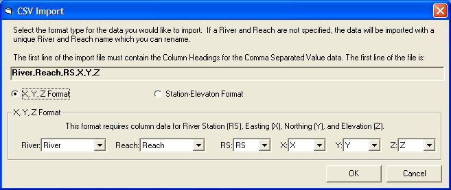
Figure 5 83. CSV data import window.
After identifying the Column Headers, using the dropdown lists, for the data in the CSV file, the standard RAS Geometric Data Import window (Figure 5-82) will appear to guide you through the import process of identifying exactly what data you would like to import. After the cross sections are imported, most likely you will need to adjust the river centerlines and establish connectivity with junctions.
One option for completing the River Network is to create a georeferenced stream centerline (or a stick figure diagram of the system). Then import the RAS cross sections onto the stream network. A detailed discussion on creating a georeferenced stream centerline is provided in a later Section of this document: Example of Georeferencing an HEC-RAS Model.
Geometric Data Importer
To import data into a HEC-RAS geometric data file, the user selects the File | Import Geometric Data menu option on the Geometric Data window. Once this option is selected, the user then selects one of the available formats from the list. Once this choice is made, a window will appear allowing the user to select a file containing the data to import. After the user has selected a file, an import window will appear to guide you through the import process.
The Import Options window will guide you through the process of importing all or part of the import file. The initial tab of the Import Options dialog is the Intro tab, shown in Figure 5-79. HEC-RAS will read the import file and look for a "UNITS" tag. Based on the value associated with the tag, you will be offered the option to import the data in the current unit system or to convert the data from one unit system to another. If no unit system is found in the file the import dialog will default to your current RAS project units.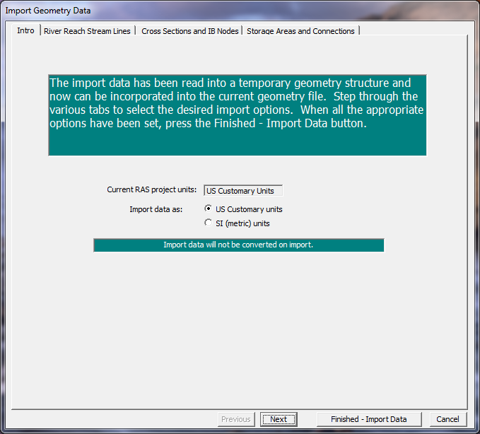
Figure 5 79. Unit system conversion is an import option in HEC-RAS
River Reach Stream Lines
The next tab on the import options window is the River Reach Stream Lines (Figure 5-80). This set of options allows you to specify which river reaches to import, how to import the data, and what to name the river and reach. Import options for the river and reaches are summarized in Table 5-2. 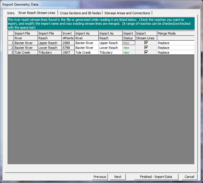
Figure 5 80. River and reach import options.
Table 5-2. Summary of River Reach Import option fields.
Column | Description |
|---|---|
Import As River | The name of the River once it is imported to RAS. |
Import As Reach | The name of the Reach once it is imported to RAS. |
Import Status | Identifies whether the river reach exists in the RAS geometry file or is new. |
Import Stream Lines | Checkbox to choose what river reaches to import. Use the spacebar to toggle the checkbox. All rows can be selected by clicking on the column header. |
Merge Mode | The river reach can replace existing data, append upstream, or append downstream. |
Cross Section and IB Nodes
The next tab on the Import Options window allows you to import cross sections and internal boundaries (bridges and inline structures). The Cross Sections and IB Nodes screen options are shown in Figure 5-81.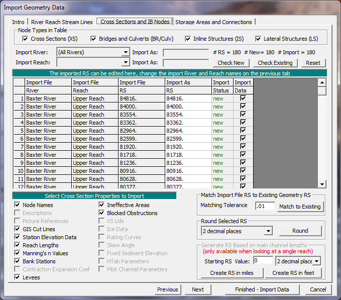
Figure 5 81. Cross section and internal boundary import options.
There are several options for importing cross-sectional data. You must first specify the Import River and Import Reach upon which the cross sections reside. The import dialog will inform you what river and reach name the data will import to (Import As) in the HEC-RAS geometry. (The Import As information was specified on the River Reach Stream Lines tab). You then specify the cross sections to import and the specific cross section properties to import.
Only those cross-sectional properties available from the import file will be available for import. Properties selected will be imported for each cross section specified during the import process. The properties import option will allow you to update individual pieces of data (such as bank station data) without modifying the other data already specified in HEC-RAS.
The cross sections that will be imported and how they will be imported are specified in the import table. Import table options are summarized in the table below.
Table 5-3. Summary of Cross Section and IB Nodes Import option fields.
Column | Description |
|---|---|
Import File River | The name of the River in the import file. Refer to the associated Import As field to see the name of the river that the cross section will be imported into. |
Import File Reach | The name of the Reach in the import File. Refer to the associated Import As field to see the name of the reach that the cross section will be imported into. |
Import File RS | The name of the River Station in the import file. |
Import As RS | The name of the River Station the cross section will be imported into. This data may be user-specified and changed using the provided tools. The "Reset" button will replace the river station data with the data in the import file. |
Import Status | The Import Status will be "New" or "Exists". New will add the cross section to the data. Exists will update (replace) the existing data with the properties specified. |
Import Data | Checkbox to choose what river stations to import. Use the spacebar to toggle the checkbox. All rows can be selected by clicking on the column header. You can also use the buttons provided to select all of the New cross sections (Check New) or those that Exist (Check Existing). |
There are also several tools provided to change the river station name. River station identifiers are the link between the GeoRAS generated data and the HEC-RAS data. Cross-sectional river stations must be numbers in HEC-RAS. HEC-RAS will use the river stations (along with River names) for determining the order of cross sections for performing water surface profile calculations. River station numbers must increase in the upstream direction. Import options for river stations allow you to match river stations to the existing geometry, round the river station value for import, and create river stationing.
Match River Stations to Existing Geometry
The Match Import File RS to Existing Geometry RS option allows you to specify a numeric tolerance to search for duplicate cross sections in existing geometry files. This tool is useful when you are re-importing cross section data where you may have modified the stream centerline or cross section layout. The newly computed river stations may differ from the original stationing due to small spatial changes made in the GIS. This tool is also convenient if you are updating cross sections that have river stations that were rounded during the initial import of the data.
Round Selected River Stations
GeoRAS may export the river stationing to more decimal places than are necessary. You can round the river stations to the precision appropriate for your study.
Create River Stations
By default, GeoRAS will compute river stations in the unit system of the digital terrain model and will use a zero station at the most downstream end of each river reach. If you wish to change the river stationing you can do so in the GIS, or you can do so during the import process. It is recommended that you document the method used if you change the river stations. Documenting the method used to compute new river stations will be important if you need to re-import cross-sectional data – the river station identifier is the link between the GeoRAS generated data and the HEC-RAS data.
Storage Areas and Connections
The Storage Areas and Connections tab, shown in Figure 5-82, allows you to specify storage areas and storage area connections to import and what name to import them with.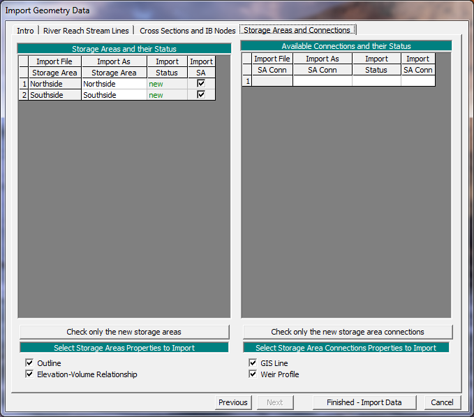
Figure 5 82. Storage Areas and Connections import options.