The evaluation of the impact of floodplain encroachments on water surface profiles can be of substantial interest to planners, land developers, and engineers. Floodplain and floodway evaluations are the basis for floodplain management programs. Most of the studies are conducted under the National Flood Insurance Program and follow the procedures in the "Flood Insurance Study Guidelines and Specifications for Study Contractors," FEMA 37 (Federal Emergency Management Agency, 11085).
FEMA 37 defines a floodway "...as the channel of a river or other watercourse and the adjacent land areas that must be reserved in order to discharge the base flood without cumulatively increasing the water-surface elevation by more than a designated height." Normally, the base flood is the one-percent chance event (100-year recurrence interval), and the designated height is one foot, unless the state has established a more stringent regulation for maximum rise. The floodway is usually determined by an encroachment analysis, using an equal loss of conveyance on opposite sides of the stream. For purposes of floodway analysis, the floodplain fringe removed by the encroachments is assumed to be completely blocked.
HEC-RAS contains five optional methods for specifying floodplain encroachments. For information on the computational details of each of the five encroachment methods, as well as special considerations for encroachments at bridges, culverts, and multiple openings, see Chapter 10 of the HEC-RAS hydraulics reference manual. This chapter describes how to enter floodplain encroachment data, how to perform the encroachment calculations, viewing the floodplain encroachment results, and how to perform a floodplain encroachment analysis within the unsteady flow computations module.
The HEC-RAS floodplain encroachment procedure is based on calculating a natural profile (existing conditions geometry) as the first profile in a multiple profile run. Other profiles, in a run, are calculated using various encroachment options, as desired. Before performing an encroachment analysis, the user should have developed a model of the existing river system. This model should be calibrated to the fullest extent that is possible. Verification that the model is adequately modeling the river system is an extremely important step before attempting to perform an encroachment analysis.
Currently, the HEC-RAS steady flow program has 5 methods to determine floodplain encroachments. These methods are:
- Method 1 -User enters right and left encroachment stations
- Method 2 -User enters fixed top width
- Method 3 -User specifies the percent reduction in
conveyance - Method 4 -User specifies a target water surface increase
- Method 5 -User specifies a target water surface increase and maximum change in energy
For unsteady flow analysis, only method one has been implemented so far in HEC-RAS. For a detailed discussion on each of these methods, the user is referred to Chapter 10 of the Hydraulic Reference Manual.
The goal of performing a floodplain encroachment analysis is to determine the limits of encroachment that will cause a specified change in water surface elevation. To determine the change in water surface elevation, the program must first determine a natural profile with no encroachments. This base profile is typically computed using the one percent chance discharge. The computed profile will define the floodplain, as shown in Figure 9-1. Then, by using one of the 5 encroachment methods, the floodplain will be divided into two zones: the floodway fringe and the floodway. The floodway fringe is the area blocked by the encroachment. The floodway is the remaining portion of the floodplain in which the one-percent chance event must flow without raising the water surface more than the target amount.
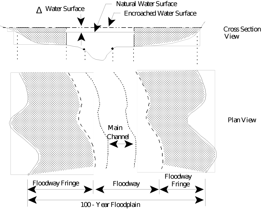
Figure 9 1 Floodway Definition Sketch