Download PDF
Download page Embankment Parameters.
Embankment Parameters
Enter data and parameters specific to DLBreach the remaining embankment parameters in the Physical Breaching (DLBreach) tab.
Embankment Geometry
The first few entries in the Physical Breaching (DLBreach) tab continue to define the embankment geometry, with parameters the other methods do not need.
Embankment Width
The embankment width is the thickness of the (flat) top of the embankment between the sloping sections. In an Inline Structure (dam) this is the a longitudinal distance (along the stream) and in a Lateral Structure (e.g. levee) this distance is lateral to the main flow direction
US Slope
This field is used to enter the slope of the embankment on the upstream side. The slope is entered in values representing the horizontal to vertical ratio. For example, a value of 2 represents 2 units moved horizontally for every 1 unit moved vertically. Note the H/V convention in HEC-RAS is opposite of the slope convention in the stand alone DLBreach
DS Slope
This field is used to enter the slope of the embankment on the downstream side. The slope is entered in values representing the horizontal to vertical ratio. For example, a value of 2 represents 2 units moved horizontally for every 1 unit moved vertically.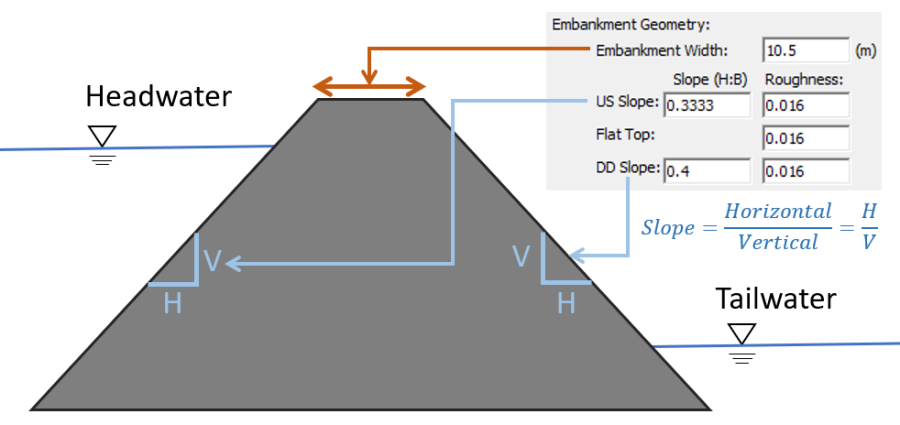
Breach Roughness
This field is used to define the Manning's Roughness Coefficient n for the breach. The breach is divided into three segments: upstream slope, flat top, and downstream slope. The user can have the same or different Manning's n values for the three segments.
Embankment Soil
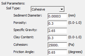
Soil Type
Specify the soil type of the embankment (cohesive or cohesionless).
Cohesive Soils:
Have enough (<0.063 mm) silt and clay (0.004 mm) content that the particles "stick" together. The surface area-to-mass ratio for these particles is so large that the electro-chemical forces between particles is larger than the frictional or gravitational forces.
If the embankment is cohesionless, DLBreach will use a non-equilibrium transport approach to erode .
Both cohesionless and cohesive soils, the following parameters must be entered: Sediment Diameter, Porosity, Specific Gravity, Clay Content, Cohesion, and Friction Angle.
All Material Types
Sediment Diameter (mm)
Enter the median sediment diameter of the core (d50).
Porosity (decimal fraction):
Define the porosity of the embankment material. The porosity is the fraction of voids and should be entered as a decimal (not percent). So if the soil porosity is 30%, enter 0.3.
Specific Gravity (unitless):
Enter the specific gravity of the embankment material. The default is 2.65, which is appropriate for almost all embankment materials.
Clay Content (decimal fraction):
Enter the clay content of the embankment if the Soil Type is Cohesive. Like porosity, enter the value as a decimal between 0.0 and 1.0 (where 0.0 is 0% and 1.0 is 100%). Do Not enter this parameter as a percent.
Cohesion (Stress Units – lbf/ft2 or Pa):
Enter the cohesion of the embankment material if the Soil Type is Cohesive.
Friction Angle (degree)
This field is used to enter the internal friction angle of the core material. The soil friction angle can be estimated according to soil types. The average frication angles are usually between:
Soil Type | Range |
Gravel | 34o-40o |
Sand | 32o-38o |
Silt | 24o-33o |
Clay | ~22o |
Wu (2016) provides the following guidance on these parameters:
"The actual friction angle may vary by ±3o–6o from the average value, because it is also affected by other properties of the soil, such as moisture, clay fraction, chemical composition, and compaction. Once the friction angle is estimated, the soil cohesion can thus be determined by using the known final breach slope."
"Furthermore, the soil cohesion and friction angle are important factors for the stability of headcut, pipe top block, and clay core, and in turn influence the breach peak discharge, breach width and failure time. Therefore, the estimated soil cohesion and friction angle can be validated indirectly by comparing these calculated breach properties against measured data."