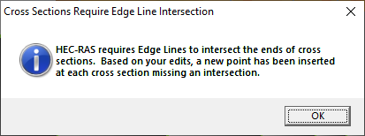
Edge lines are used to limit the extents of inundation mapping and are typically the bounds of the cross sections. These are an editable feature. This allows you to map an area where the mapping between cross sections is not seamless or an area that is in backwater not included in the cross section layout. The edge lines should be modified prior to running your model because they will be copied to the results data and used for mapping. Lastly, create the interpolation surface once the edge lines have been completed to see what results. Note: the Edge Lines must intersect with the end points of each cross section. If they do not, RAS Mapper will automatically insert a point on the Edge Line and provide a user warning message.
Edge lines can be auto-computed based on the ends of the cross sections by right-clicking on the Edge Lines layer and selecting Create Edge Lines at XS Limits. The edge lines are computed based on the shape of the River centerlines, Bank Lines, and the layout of the Cross Sections. This will give the user a good starting point for modification.