The Rivers layer is used to represent the river network for flow connectivity. The River line will be used to compute the River Station for each Cross Section element based on the distance from the downstream end of the River (zero defines the most downstream point on the river line). The units used to compute the river stationing be defined by the "XS River Stations Units" option. The river centerline will also be used to compute the Channel Reach Length property for the cross section.
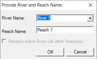
Rivers must be created in the downstream direction. When a river has been completed, the Rename River and Reach Name dialog will be invoke. Provide a unique River and Reach name for the river segment and press OK to accept the line and name. River names must be unique throughout the model and reach names much be unique for each river.
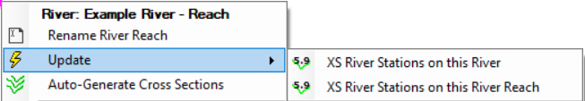
Once a River Reach has been created, right-click will provide options for to rename the River Reach, update the river stationing on cross sections, and to auto-generate cross sections at a specified width and spacing.