The Corps Water Management System (CWMS) is the automated information system used by the U.S. Army Corps of Engineers (USACE) to support its water control management mission. This mission encompasses the
regulation of river flow through more than 700 reservoirs, locks, and other water control structures located throughout the Nation. CWMS is an integrated system of hardware and software that begins with the
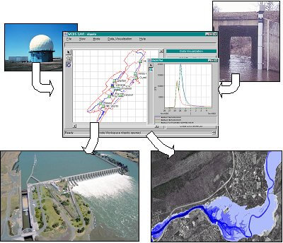
receipt of hydromet, watershed, and project status data. This data is then processed, stored, and made available through a user friendly interface to the water manager to evaluate and model the watershed. Both
model and processed data can be displayed and disseminated in tabular, graphical, and/or geo-spatially resulting in an effective decision support system.
Types of incoming real-time data include: river stage, reservoir elevation, gage precipitation, WSR-88D spatial precipitation, quantitative precipitation forecasts (QPF) and other hydro-meteorological
parameters. These data are used to derive the hydrologic response throughout a watershed area, including short-term future reservoir inflows and local uncontrolled downstream flows. The reservoir operation model
flows are then processed to provide proposed releases to meet reservoir and downstream operation goals. Then, based on the total expected flows in the river system, river profiles are computed, inundated areas
mapped, and flood impacts analyzed.
CWMS allows evaluation of any number of operation alternatives before a final forecast scenario and release decision are adopted. For example, various alternative future precipitation amounts may be considered,
hydrologic response may be altered, reservoir release rules may be investigated, and alternative bridge obstruction, levee integrity, or other river conditions may be evaluated. When an operational decision is
made the results, along with supporting hydromet, watershed, and project status and release data may be disseminated to others via web technology.
The system emphasizes visualization of information in time and space. The primary CWMS user interface is map based to provide clear spatial reference for watershed and modeling information. CorpsView, a USACE
developed spatial visualization tool based on commercially available GIS software, provides a direct user interface to GIS products and associated spatial attribute information.
CWMS has been deployed to over 35 Corps District and Division offices with a water management mission. CWMS is currently available only to USACE offices.
CWMS is "live" 24/7, continuously providing support during routine high and low flow periods, and during emergencies. CWMS is self-monitoring providing automated status information on components and
processes, and alerting to service needs.
CWMS is only available to USACE offices. Non-USACE individuals with an interest in what CWMS provides can get the public version, HEC-RTS (Real Time Simulation)
from this website.
You can contact the CWMS System Developer directly at: Webmaster-HEC@usace.army.mil