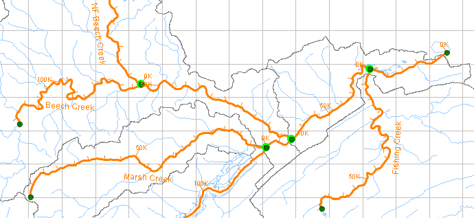
The Stream Alignment represents the river system of the watershed. It indicates where confluences and bifurcations occur and provides a sense of distance and scale. It also imposes a flow direction for reaches and reservoirs that are created with respect to it. "Figure: Stream Alignment" shows the stream alignment created for one of the example watersheds that are provided with ResSim.
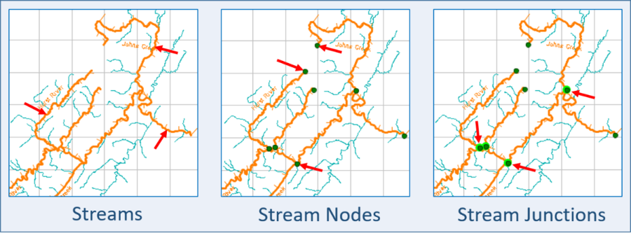
The Stream Alignment is made up of streams, stream nodes, and stream junctions. "Figure: Stream Alignment Components" illustrates these components of the Stream Alignment. Although you can change the drawing properties of the elements of the stream alignment, by default, streams are drawn in orange, stream nodes in dark green, and stream junctions are symbolized by a bright green halo around a stream node.
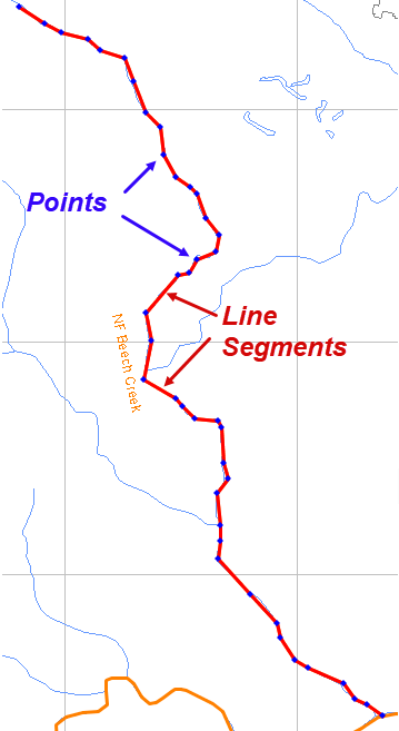
A stream in the stream alignment is defined by an ordered set of points or vertices that ResSim connects with straight line segments to form a "polyline". The Stream Alignment Tool is used to draw and edit streams in the Stream Alignment. When you create a stream, you will draw it, from upstream to downstream, as a series of points. "Figure: Visualization of a Stream" illustrates the points and line segments that define a stream in the stream alignment. NOTE: Each stream should be a continuous element that represents a named watercourse in the river network; a river should not be broken up into discrete streams (reaches) at each confluence.
For each stream you create, ResSim will create two stream nodes and place them on the stream, one at the upstream-most end of the stream and one at the downstream-most end. When you connect one stream to the middle of another stream, ResSim will add an additional stream node to the existing stream at the point of connection. That connection, usually representing a confluence of two streams, is referred to as a stream junction and is denoted by the bright green halo around the stream node(s). Each stream junction contains a stack of at least two stream nodes, one for each stream entering and/or leaving the junction. Stream nodes and stream junctions are managed using the Stream Node Tool in the Watershed Setup module.
ResSim applies stream stationing to each stream in the stream alignment. By default, the stationing of a stream starts at zero at the downstream end and increases upstream along the stream as an accumulation of the lengths (in the watershed coordinate system and units) of the line segments that describe the stream. The stream stationing is reflected in the drawing of the stream alignment with tic marks and tick mark labels. You can override the default stationing by editing the station values of the stream nodes at the upstream and downstream ends of the stream element. You can also add additional stream nodes along the stream and override their default station values, thereby imposing a "piece-wise" stationing between each pair of stream nodes.
To work with the stream alignment in any way, you must be in the Watershed Setup module and you must lock the configuration for editing:
- Select Watershed Setup from the Module selector on the Module Bar