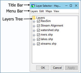
The Layer Selectormanages the organization and properties of the various Map Display Layers described above, including the Stream Alignment layer, the schematic layers, and the map layers.
To access the Layer Selector ("Figure: Layer Selector") from any module: Select Layers… from the View menu.
Figure: Layer Selector
Layer Selector Menus
The menus of the Layer Selector provide a variety of tools for managing the layers displayed in the Map Display area. If a command or option in a menu is greyed-out, the option is unavailable either because you have not turned on Allow Layer Editing from the Edit menu or the option cannot be used for the currently selected layer in the Layers tree. The menus of the Layer Selector include:
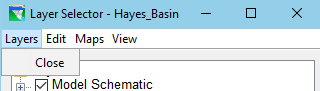
Layers ("Figure: Layers Menu")—This menu is equivalent to a File menu. However, since the Layer Selector does not manage a file that contains its configuration settings, the only option in the Layers menu is Close, which will close the Layer Selector. Other ways to close the Layer Selector include:
Figure: Layers Menu
The OK and Cancel buttons at the bottom of the Layer Selector
The X at the end of the Title Bar
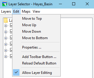
Edit("Figure: Edit Menu")—this menu provides tools for rearranging layers, viewing and editing layer properties, and adding and removing user toolbar buttons.
Figure: Edit Menu
Allow Layer Editing—The Layer Selector uses a "locking" concept similar to that used by the Watershed Setup and Reservoir Network modules. The Layer Selector always opens in an "unlocked" state which limits the functions that you can perform on the existing layers and does not allow you to add layers. To enable all (or most) of the functionality in the Layer Selector, you must first "lock" it for editing by selecting Allow Layer Editing from the Edit menu. When editing is enabled, a checkbox appears next to the Allow Layer Editing menu item as shown in "Figure: Edit Menu".
Move to Top, Move Up, Move Down, Move to Bottom—These commands change the position of the currently selected layer in the Layers tree and how the layer is drawn in the Map Display. The current position of the selected layer will determine which Move commands are available in the Edit menu. When a layer is already at the top, the Move to Top and Move Up options will be unavailable. Likewise, if a layer is at the bottom, the Move Down and Move to Bottom options will not be available.
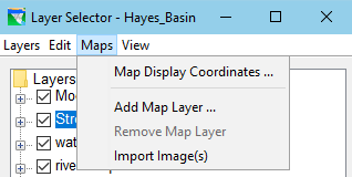
Maps ("Figure: Maps Menu")—This menu allows you to add and remove map layers, as well as import images as layers. The Map Display Coordinates option opens the Geographic Region editor. These functions are described in "Adding and Removing Map Layers".
Figure: Maps Menu
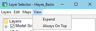
View ("Figure: View Menu")—this menu has the following two options that impact the "view" of the Layer Selector itself:
Figure: View Menu
Expand / Collapse—This option causes the selected layer in the Layers tree to display its sub-layers (or Legend). This is the same functionality as clicking on the plus-sign of the selected layer in the tree. Once you have expanded a layer, Expand changes to Collapse in the menu. Use Collapse to cause the selected layer to hide its sub-layers or Legend. This is the same functionality as clicking on the minus-sign of the selected layer in the tree.
Always on Top—This option in the View menu is a "toggle switch". When active or ON, this option keeps the Layer Selector on top of all other windows on your desktop. If a checkmark precedes this option in the View menu, the option is active.