Download PDF
Download page CWMS Overview.
CWMS Overview
The CWMS software readily provides water managers with data and information. CWMS is a client-server system, with the Sun® Solaris platform on the server side and Microsoft Windows® on the CWMS client side. Hardware and software configurations are customized for each USACE district, but the CWMS software provides the same basic functions to all USACE districts. From the Control And Visualization Interface (CAVI), which is the GUI for CWMS, the user (referred to as "you" from here on) can configure watersheds, view and edit data and information, setup and run forecasts, and view results. The functions of CWMS are organized into four groups (modules) - acquisition, visualization, modeling, and setup.
The Acquisition Module contains the commands for data acquisition. These commands include: monitoring receipt of data by the CWMS database (HEC's Data Storage System, DSS), files for gridded data, validating the quality of incoming data, transforming the data (e.g., stage to flow), and editing the data, as required. The CWMS server is configured to receive real-time data and forecasts from a wide variety of sources. For example, when CWMS was installed at USACE, Galveston District, streamflow data was acquired from the U.S. Geological Survey (USGS), rainfall data came from the Harris County Flood Control District, and rainfall forecasts came from the National Weather Service (NWS). All of this data is processed and transformed to a consistent format in the CWMS database. Computation results from sources outside CWMS may also be acquired.
The Visualization Module contains the commands for data visualization. These commands include displaying observed and forecast data to evaluate the hydrometeorological state of the watershed. Water managers may need to review hourly data from hundreds of gages as decisions are made. CWMS CAVI provides tools to facilitate review of large amounts of data, including summaries presented as graphs, tables, spreadsheets, charts, river profiles, maps, or sometimes a combination of these. Within CWMS, the summaries are linked to a watershed map, so that you can click on an icon on the map, and immediately view the data associated with that location. This module also displays results of computations.
The Modeling Module contains the commands for model execution. These commands assist with setting up and executing the analysis software for forecasting and viewing results.
The Setup Module contains commands for watershed setup. These commands include: configuring inputs, models, and outputs that describe a watershed's behavior. A visual representation of the watershed is developed and displayed in the CAVI that is map-based.
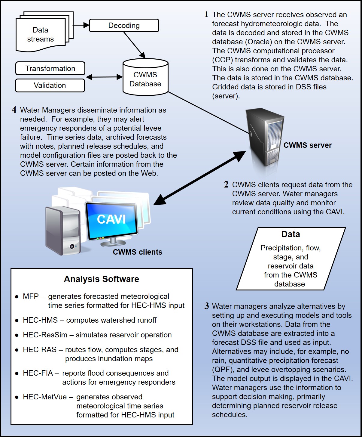
The CWMS software has a mechanism that links the selected analysis software for a forecast, so that the selected software applications are executed in an orchestrated manner. Data and other inputs are passed to each piece of analysis software through the DSS data exchange software. The available analysis software in CWMS meets modern software standards, including an easy-to-use GUI, and executes within operating systems selected by USACE. The analysis software available in CWMS Version 3.2.2 is:
HEC-MetVue
Meteorological Visualization Utility Engine - processes observed meteorological data for input to HEC-HMS (Hydrologic Modeling System). Inputs are either point or gridded estimates of meteorological data such as precipitation and temperature. Outputs are observed meteorological time series formatted for compatibility with HEC-HMS.
MFP
Meteorologic Forecast Processor - processes meteorological forecasts for input to HEC-HMS. Inputs are forecasted meteorological data such as precipitation and temperature. These forecasts can be entered manually or obtained from external sources such as NWS (National Weather Service). Outputs are forecasted meteorological time series formatted for compatibility with HEC-HMS.
HEC-HMS
Hydrologic Modeling System - simulates watershed response to precipitation. Inputs may include observed or forecasted precipitation, temperature, snowpack, and other environmental conditions. Outputs include flows throughout the watershed, including inflows to reservoirs and local flows below the reservoirs.
HEC-ResSim
Reservoir System Simulation - simulates behavior of reservoirs and linking channels, following user-specified operations for reservoir release decision making. Inputs include flows into reservoirs and unregulated flows downstream of reservoirs (from HEC-HMS). Outputs include reservoir releases, downstream regulated flows, and reservoir storage conditions.
HEC-RAS
River Analysis System - simulates behavior of channels and adjacent floodplains. The simulation of channels is performed one-dimensionally, while the simulation of adjacent floodplains can be performed one- or two- dimensionally. The output from HEC-RAS permits determination of water surface elevations corresponding to flows computed by HEC-HMS or HEC-ResSim. Inputs include flows, and outputs include water surface elevations, depth grids, and inundation maps.
HEC-FIA
Flood Impact Analysis - estimates the consequences of flow or water surface elevations in the system. Inputs include computed or observed flows or water surface elevations throughout the flood plain. Outputs include economic, life loss, or other measures of impact, or optionally, information on actions to be taken in response to flows or water surface elevations that will be experienced.
The CWMS software ensures that the current state of a water control system and likely future states of that system, are readily available to water managers. The capability to access this information is accomplished through information sharing technology, including specially designed websites for display. The flow of data and information through CWMS is displayed in Figure 1.
