Download PDF
Download page Coordinate System Types.
Coordinate System Types
A coordinate system is a system that uses numbers (coordinates) to determine the position of a point or geometric element within a geographic framework. There are several different types of coordinate systems: geographic coordinate systems, which are based on latitude and longitude coordinates; and projected coordinate systems, which represent the projection of a geographic coordinate system on a plane and use linear measures (like feet or meters) for coordinates. A spheroid (ellipsoid) is the shape of the Earth used in the calculations that transform positions on the curved surface of the Earth to positions on a flat map. It is part of the horizontal datum, which approximates the curved surface of the Earth over part of the globe.
The coordinate systems available in CWMS are shown in the table below.
Coordinate Systems | Units |
X-Y | Liner units (feet or meters) |
Google/Bing Web Mercator | Liner units (feet or meters) |
Geographic | Angular units (radians, degrees of arc, or seconds) |
Universal Transverse Mercator | Liner units (feet or meters) |
State Plane Coordinates | Liner units (feet or meters) |
Albers Equal-Area Conic | Liner units (feet or meters) |
Lambert Conformal Conic | Liner units (feet or meters) |
Transverse Mercator | Liner units (feet or meters) |
Albers Equal-Area Conic (SHG) | Liner units (feet or meters) |
Polar Stereographic (HRAP) | Liner units (feet or meters) |
The following sections provide information about each coordinate system that is recognized by CWMS. Once a watershed is created, you cannot change the coordinate system.
X-Y Coordinate System
The label X-Y can be applied to a coordinate system that is either not geo-referenced or for which the geo-referencing method is unknown. When the X-Y coordinate system is selected, CWMS CAVI cannot project maps to the watershed's coordinate system.
To set parameters for the X-Y coordinate system:
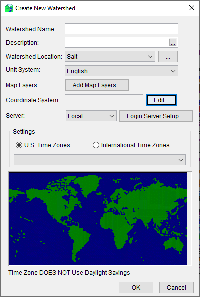
- From the Create New Watershed dialog, click Edit next to the Coordinate System box. The Map Coordinate Information dialog will open.
- From the System dropdown list, select X-Y.
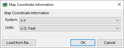
- From the Units dropdown list, select the units for the X-Y coordinate system.
- Click OK, and the Map Coordinate Information dialog will close.
Google/Bing Web Mercator Coordinate System
To set parameters for the Google/Bing Web Mercator coordinate system:
- From the Create New Watershed dialog, click Edit next to the Coordinate System box. The Map Coordinate Information dialog will open.
- From the System dropdown list, select Google/Bing Web Mercator.

- Click OK, and the Map Coordinate Information dialog will close.
Geographic Coordinate System
To set parameters for the Geographic coordinate system:
- From the Create New Watershed dialog, click Edit next to the Coordinate System box. The Map Coordinate Information dialog will open.
- From the System dropdown list, select Geographic.
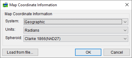
- From the Units dropdown list, select the units for the Geographic coordinate System. The only units available are Radians, Seconds of Arc, and Degrees of Arc.
- From the Spheroid dropdown list, select a spheroid type. (The Sphere of Radius 6371200 meters should only be used with the HRAP grid coordinate system.)
- Click OK, and the Map Coordinate Information dialog will close.
Universal Transverse Mercator Coordinate System
The Universal Transverse Mercator (UTM) coordinate system is a projected coordinate system. UTM is used to define horizontal positions throughout the world by dividing the surface of the Earth into six-degree zones, with a central meridian in the center of each zone.
To set parameters for the Universal Transverse Mercator Coordinate System:
- From the Create New Watershed dialog, click Edit next to the Coordinate System box. The Map Coordinate Information dialog will open.
- From the System dropdown list, select Universal Transverse Mercator.
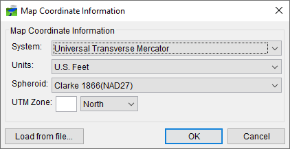
- From the Units dropdown list, select the units for the Universal Transverse Mercator coordinate system.
- From the Spheroid dropdown list, select a spheroid type for the Universal Transverse Mercator coordinate system.
- In the UTM Zone box, enter the UTM zone number. Select North or South from the dropdown box, depending on which hemisphere your watershed is located in.
- Click OK, and the Map Coordinate Information dialog will close.
State Plane Coordinates System
The State Plane Coordinates System (SPCS) was established in the 1930's and now covers all fifty states. Zones were established for each state using either the Lambert Conformal or Traverse Mercator projections. Units are generally in feet (NAD27) or meters (NAD83).
To set parameters for the State Plane Coordinates coordinate system:
- From the Create New Watershed dialog, click Edit next to the Coordinate System box. The Map Coordinate Information dialog will open.
- From the System dropdown list, select State Plane Coordinates.
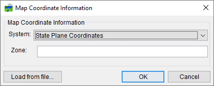
- In the Zone box, enter the FIPS code for the state plane zone.
- Click OK, and the Map Coordinate Information dialog will close.
Albers Equal-Area Conic Coordinate System
The Albers Equal-Area Conic projection is used by several federal government agencies for maps of the conterminous 48 states. HEC uses an Albers projection for the definition of the Standard Hydrologic Grid. The equal area property of this projection means that areas in the map are proportional to the corresponding areas on the earth's surface. Directions and shapes distort increasingly away from the central meridian and outside the two standard parallels.
To set parameters for the Albers Equal-Area Conic Coordinate System:
- From the Create New Watershed dialog, click Edit next to the Coordinate System box. The Map Coordinate Information dialog will open.
- From the System dropdown list, select Albers Equal-Area Conic.
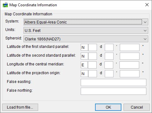
- From the Units dropdown list, select the units for the Albers Equal-Area Conic coordinate system.
- From the Spheroid dropdown list, select a spheroid type for the Albers Equal-Area Conic coordinate system.
- The remaining items to be entered are the angular parameters that are required to fine-tune the projection. When specifying latitudes, you will enter N or S, and for longitudes, you will enter E or W. Use your tab key to toggle between the entries.
- Enter the False easting and False northing measurements in the respective boxes.
- Click OK, and the Map Coordinate Information dialog will close.
Lambert Conformal Conic Coordinate System
The Lambert Conformal Conic projection is used extensively for mapping areas of the world with predominantly east-west orientation. It is similar to the Albers Equal-Conic projection, but the projection is not done in an equal-area.
To set parameters for the Lambert Conformal Conic coordinate system:
- From the Create New Watershed dialog, click Edit next to the Coordinate System box. The Map Coordinate Information dialog will open.
- From the System dropdown list, select Lambert Conformal Conic.
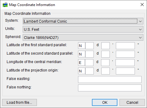
- From the Units dropdown list, select the units for the Lambert Conformal Conic coordinate system.
- From the Spheroid dropdown list, select a spheroid type for the Lambert Conformal Conic coordinate system.
- When specifying latitudes you will enter N or S, and for longitudes, you will enter E or W. Use your tab key to toggle between the entries.
- Enter the False easting and False northing measurements in the respective boxes.
- Click OK, and the Map Coordinate Information dialog will close.
Transverse Mercator Coordinate System
The Transverse Mercator projection is where a sphere is projected onto a cylinder tangent to a central meridian. It is similar to the Lambert Conformal Conic project but is used to portray large areas in a north-south orientation. Many national grid systems are based on the Transverse Mercator projection.
To set parameters for the Transverse Mercator coordinate system:
- From the Create New Watershed dialog, click Edit next to the Coordinate System box. The Map Coordinate Information dialog will open.
- From the System dropdown list, select Transverse Mercator.
- From the Units dropdown list, select the units for the Transverse Mercator coordinate system.
- From the Spheroid dropdown list, select a spheroid type for the Transverse Mercator coordinate system.
- Enter a scaling factor for central meridian in the Scale factor at central meridian cell.
- When specifying latitudes you will enter N or S, and for longitudes, you will enter E or W. Use your tab key to toggle between the entries.
- Enter the False easting and False northing measurements in the respective boxes.
- Click OK, and the Map Coordinate Information dialog will close.
Albers Equal-Area Conic (SHG) Coordinate System
The Albers Equal-Area Conic (SHG) is a special case of the Albers Equal-Area Conic coordinate system; the horizontal units are US Feet instead of meters. The projection parameters are set to match USGS 48-state maps, which are used for several common data sources including precipitation data on the Standard Hydrologic Grid. This coordinate system is the preferred coordinate system within CWMS watersheds. You can quickly set your watershed to the preferred coordinate system by selecting the SHG system and then switching the units to "US Feet".
To set parameters for the Albers Equal-Area Conic (SHG) coordinate system:
- From the Create New Watershed dialog, click Edit next to the Coordinate System box. The Map Coordinate Information dialog will open.
- From the System dropdown list, select Albers Equal-Area Conic (SHG).

- From the Units list, select the units for the Albers Equal-Area Conic (SHG) coordinate system. (If using the standard CWMS projection, change the units to US Feet)
- From the Spheroid list (Figure 10), select a spheroid type for the Albers Equal-Area Conic (SHG) coordinate system.
- The remaining parameters are informational and are not editable.
- Click OK, and the Map Coordinate Information dialog will close.
Polar Stereographic (HRAP) Coordinate System
The Polar Stereographic Hydrologic Rainfall Analysis Project (HRAP) grid is used by the US National Weather Service for a variety of precipitation products. The row and column numbers in the grid are based on a Polar Stereographic projection of the northern hemisphere. The parameters are set to match NWS map coordinates used for radar grids, so do not change any parameter settings if using this projection.
To use the parameters for the Polar Stereographic (HRAP) coordinate system:
- From the Create New Watershed dialog, click Edit next to the Coordinate System box. The Map Coordinate Information dialog will open.
- From the System dropdown list, select Polar Stereographic (HRAP).
- The remaining parameters should not be edited from their default settings.
- Click OK, and the Map Coordinate Information dialog will close.