Download PDF
Download page Creating a Watershed.
Creating a Watershed
When you create a new watershed, you will need to provide a few details about it including:
- a name and description
- its directory location (on disk)
- the units of measure of the data and computations
- the Time Zone in which it is located
- the Stream Alignment Units
- if the model will use Water Quality
Once you have created your new watershed, ResSim will generate a new folder in the directory you specified; the folder name will be the name you gave your watershed. Your new watershed will then become the open watershed in ResSim, and the tools needed to create watershed data will become available in the ResSim user interface. After creating the watershed, you will proceed with other watershed setup tasks such as adding background maps, setting preferences for the map display, etc., as described later in this chapter.
Defining a Watershed Location
A Watershed Location is the place on disk where you store your watersheds. You can have multiple watershed locations, although an individual watershed cannot span multiple locations. Each watershed location is given an alias (or logical name) such as My Watersheds or Current Projects.
In prior versions of ResSim, you were required to create at least one watershed location (shortcut) before you could create a watershed. In this version, that requirement has been removed; however there are still features in ResSim that expect your watershed to reside in a known watershed location so we recommend that you continue to create and use specified watershed locations for storing your watersheds.
So, before you create or open a watershed, you should define at least one watershed location. To define a watershed location, a.k.a., a Shortcut:
From the Tools menu, select Options…. The ResSim Options editor ("Figure: ResSim Options Dialog - Shortcuts") will open.
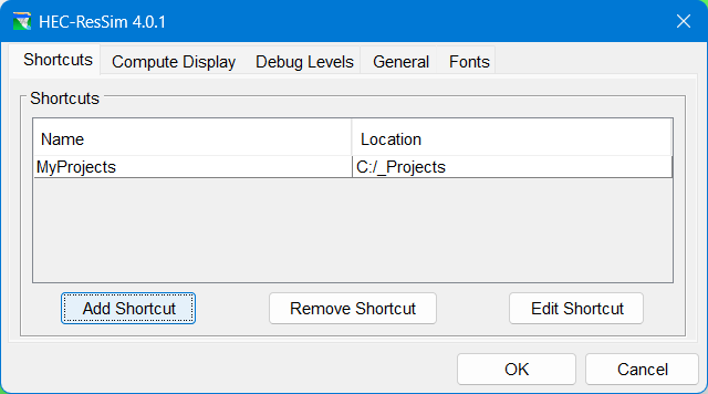
Figure: ResSim Options Dialog - Shortcuts
Select the Shortcuts tab. The Name and Location of any watershed locations you have previously defined will display in the Shortcuts list.
To add a new location to the list, click the Add Shortcut button. The Add Shortcut dialog will open ("Figure: Add Shortcut Dialog").

Figure: Add Shortcut Dialog
Enter a Name (or Alias) for the new location/shortcut, then click Browse…. A file browser dialog will open ("Figure: ResSim File Browser"). Use it to select the folder on disk where you want to store your watershed(s). Click OK to close the file browser and accept the selected folder as your shortcut's location.

Figure: ResSim File Browser
- Click OK to finish creating your shortcut and close the Add Shortcut dialog. The new location/shortcut will now appear in the list of Shortcuts on the Shortcuts tab. Refer to "ResSim Application Settings" for information about other options available in the Options dialog.
Creating a New Watershed
Once you have established a watershed location, you can create a new watershed.
To create a new watershed:
Select New Watershed from the File menu. The Create New Watershed dialog ("Figure: Create New Watershed Dialog")will open.

Figure: Create New Watershed Dialog
- Enter a Name for the new watershed. The watershed name must be less than 32 characters. Because the Name will be used for both a directory and a filename in your file system, the watershed name cannot contain any of the following characters:
/ : * ? " < > - \. - Enter a Description for the new watershed.
- Select a Location (a working directory) for the new watershed's directory from the file browser. A new folder representing your watershed will be created in the Location you select. The new folder will be given the Name of your watershed.
- Select the watershed's Units—your options are English (U.S. customary units) or SI (System International). See "Units of Measure" below, for more information.
- Set the watershed's Time Zone by selecting from the list of standard time zones. See "Time Zone" below, for more information.
- Select the Stream Alignment Units
- If the model will be using Water Quality, then check the Use Water Quality box
- Click OK to create the watershed and close the Create New Watershed dialog.
A Watershed Summary confirmation dialog ("Figure: Watershed Summary Dialog") will open showing your selections. Review the settings carefully, then select:

Figure: Watershed Summary Dialog
OK—if the settings are all correct and you want to proceed with creating the watershed.
< Back—If you want to change any of the settings.
Cancel—if you do not want to create the new watershed.
Be Careful…
You cannot change the watershed's Name, Units, or Time Zone after the watershed has been created.
Units of Measure
The watershed's Units is the unit system in which the watershed will perform its calculations and store its data and results. The options are English and SI. English (or U.S. Customary) units include feet, acres, cfs, Fahrenheit, etc. SI (or Metric) units include meters, hectares, cms, Celsius, etc.
Be aware that you cannot change the watershed units once you have created the watershed. However, you can (at any time) change the display units using the View menu; so even if you select SI as the watershed units, you can set the display units to English which will allow you to enter data and view results in English units.
ResSim will check the units of all input time-series data and will convert the data, if necessary, to watershed units before beginning the computations. This means that input time-series data can be provided in English or SI units, or both.
Time Zone
When you create a new watershed, you must select a time zone for the watershed. This typically would be the time zone for the dam or for most of the watershed, although you may have reasons for selecting a different time zone. All time zones in the list provided when you create the watershed are considered “standard” time zones. They each utilize a fixed time offset from GMT and do not adjust for Daylight Savings Time.
ResSim will use the watershed time zone to store all time-series data that it generates. It will also adjust any input time-series data with a specified time zone that is different from that of the watershed into “watershed time” before beginning the computations. If any input time-series data does not have a specified time zone, ResSim will assume that the data is in watershed time.