Download PDF
Download page Water Quality Module – Menu Bar.
Water Quality Module – Menu Bar
The Water Quality module (Figure 2.19) contains six menus; however, all but one of these menus is unique to the Water Quality module. The File, View, Alternative, Tools and Help menus contain the same commands as those in the same menus opened from the Reservoir Network module (refer to the HEC-ResSim Version 4.0 User's Manual). For example, the Alternative menu contains one command, Edit, which opens the HEC-ResSim Alternative Editor from both the Reservoir Network module and the Water Quality module. Therefore, this section will describe the Water Quality menu (figure below), which is unique to the Water Quality module (Figure 2.19).
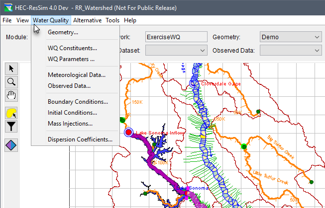
The table below provides a list of Water Quality menu (figure above) commands that are used to open editors for creating and defining various water quality data sets for water quality model data (which can then be selected from the various Module Data lists, e.g., from the Geometry Dataset module data list GeometryData1 selected in Figure 2.19).
Commands | Description |
|---|---|
Geometry | This command opens the Geometry Editor used for creating and defining geometry dataset(s). The geometry dataset is a key water quality modeling component. The user creates a geometry dataset and links the geometry to an HEC-ResSim Network (created in the Reservoir Network module as described in the HEC-ResSim User's Manual) and the HEC-RAS Geometry (see HEC-RAS User's Manual). Chapter 4 of this manual gives greater details regarding creating, defining and modifying geometry datasets. |
WQ Constituents | This command opens the WQ Constituent Set Editor used for defining WQ constituent set(s). The user can select water quality constituents from the three water quality libraries: Temperature, N1MI, and General Constituent Simulation Module (refer to Chapter 5 and Appendix B for more information on the constituent set and libraries, respectively). |
WQ Parameters | This command opens the WQ Parameter Set Editor used for defining WQ parameter set(s). When a WQ parameter set is created, it must be linked to a geometry dataset and to at least one WQ constituent set. Chapter 6 of this manual offers greater detail regarding creating, defining and modifying WQ parameter datasets. |
Meteorological Data | This command opens the Meteorological Dataset Editor used for specify one or more Met stations and defining Met dataset(s) for each station. A Met dataset is required for water temperature modeling and must be linked to a geometry dataset (from the Geometry Editor). The meteorological dataset includes the following: atmospheric pressure, air temperature, humidity, shortwave radiation, cloudiness, and wind speed. For more information regarding Met datasets, refer to Chapter 3. |
Observed WQ Data | This command opens the Observed Dataset Editor, which is used to specify observed datasets for one or more Observed stations. Typically, an observed dataset is used for model calibration and/or validation. Chapter 7 contains more information regarding observed datasets. |
Boundary Conditions | This command opens the Boundary Condition Set Editor which is used to define water quality boundary conditions for simulated constituents at all locations where local flow enters the system. When a boundary condition set is created, it must be linked to a geometry dataset and a WQ constituent set. Refer to Chapter 8 for more information regarding boundary condition sets. |
Initial Conditions | This command opens the Initial Condition Set Editor, which is used to define initial water quality conditions of simulated constituents for river reach and reservoir. When an initial condition set is created it must be linked to a geometry dataset and a WQ constituent set. Refer to Chapter 9 for more information regarding initial condition sets. |
Mass Injections | This command opens the Mass Injection Set Editor, which is used to define a mass injection set for one or more mass injection locations. When a mass injection set is created, it must be linked to a geometry dataset and a WQ constituent set. See Chapter 11 for more information regarding initial condition sets. |
Dispersion Coefficients | This command opens the Dispersion Coefficient Set Editor used to define dispersion coefficient set(s). When a dispersion coefficient set is created, it must be linked to a geometry dataset. This editor is used to define confidents for reaches and reservoirs and the vertical diffusion method for reservoirs in the geometry. Chapter 10 provides more information regarding dispersion coefficient sets. |