Geo-Referencing HEC Grids
Summarizing very briefly, the cells in HEC grids are referenced by row and column number, with numbers increasing upwards and to the right (or to the north and east) away from an implied origin cell in row 0, column 0. The positioning and numbering of the rows and columns are set in advance, so that a cell's row and column indices become a form of geo-referencing. Once a system of row and column numbering is established, a given pair of row and column numbers always refers to the same area on the earth's surface. The value in any cell is retrieved by reference to its row and column numbers, rather than by northing and easting coordinates in feet or meters. This system of indirect geo-referencing by row and column number was implemented in HEC-DSS and HEC-HMS to take advantage of precipitation data provided by the US National Weather Service using the Hydrologic Rainfall Analysis Program (HRAP) grid, and later generalized to support other coordinate systems. The grid systems currently in use in HEC-DSS are described in Appendices B, C, and D.
The grid stored in a single DSS record or represented by a single GridData object covers a range of rows and columns, starting from an origin cell, identified by a pair of integer indices, and covering an extent of rows and columns identified by another pair of integers. Cell positions can be geo-referenced by multiplying the cell's row and column number by the cell size. This gives northing and easting values in the coordinate system that the grid is referenced to. (The HRAP and SHG grid systems place cell 0, 0 at the origin of their coordinate systems; an additional offset can be used if cell 0, 0 is placed at a different position.)
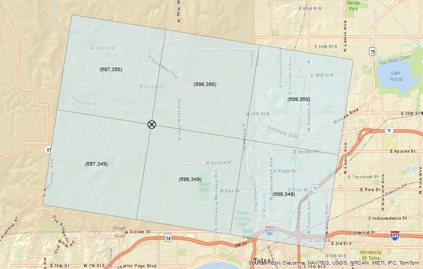
Figure 1: HRAP Cells Located Near Tulsa, OK
Figure 1 shows a small HRAP grid located near Tulsa, OK. This grid has origin cell indices 597, 349 and extents of two rows and three columns. To find geo-referenced coordinates for the "X" at the southwest corner of cell (598, 350) multiply the cell's row and column numbers by the HRAP cell size of 4,762.5 m. This locates the point at easting 2,843,212.5 m and northing 1,666,875 m expressed in HRAP's Polar Stereographic coordinate system. (See Appendix B for details of the HRAP grid.) Back-projecting gives the geographic position (to the nearest second) at 96°3'2" W and 36° 12' 7" N.