Download PDF
Download page Roads.
Roads
In real life, the ecological influence of roads is complex and involves land changes, pollution, noise, habitat fragmentation, and numerous other affects. In EFMSim, roads can generate attractions and repulsions that influence the movement of mobile communities and be a source of mortality as communities and classes move across roads. Road attractions and mortalities are covered in the Logic section of this manual. In EFMSim, road maps are collections of polylines identified by road type and road name. Road maps can be generated via the Layer Selection – Layers – Human – Roads – Add Road Map… or Import Road Map… menu options. Import is done via a five-step wizard to pick whether the source is an existing road map or external data layer, selecting the source, selecting roads to import, selecting road types, and selecting road names (Figure).

Figure. The Import Road Maps wizard allows import from existing road maps or external data layers.
Before road maps can be used in simulations, polylines need to be aligned with element edges of layouts because movement of mobile communities is done as a flux of organisms between neighboring elements. Road maps are stored under the Layer Selection – Layouts – Human – Roads node. Right clicking on a roads map will offer a menu option for Create Snap Map…
Creating and Working with Snap Maps
There are several options associated with the creation of snap maps. The Create Snap Map interface allows users to specify a snap map name, associated layout, and segment length for all road types or per type (Figure). Snap map names must be unique per road map and layout pairing. When a snap map is created, road polylines are split into segments and floated to the nearest element edge. Road lengths are stored per element edge and road type. Snap maps can be renamed, saved with a different name, deleted, reprocessed, synched with its parent layout, associated with a different layout, and manually edited. Snap maps are stored under the Layer Selection – Layouts – Human – Roads – Road Map(s) nodes. Hovering the cursor over an existing snap map will provide a tooltip with date and time last modified, date and time created, road map name, date and time road map last edited, method, and segment length.

Figure. The Create Snap Map interface allows users to align roads with layout element edges.
There is also an option to redistribute segments floated to element edges when those faces have less than a user-defined percentage of the road type length present in the associated element. Faces with less than the threshold percentage are added to the neighboring face with most length again and again until all faces with length have greater than or equal to the percentage. Redistributing starts with the smallest face percentage per element. When a face with less than the user-defined percentage doesn’t have any neighbors with length, then its length is moved to its element face with the biggest length. This is an automated approach to dealing with road spurs created during the floating of segments.
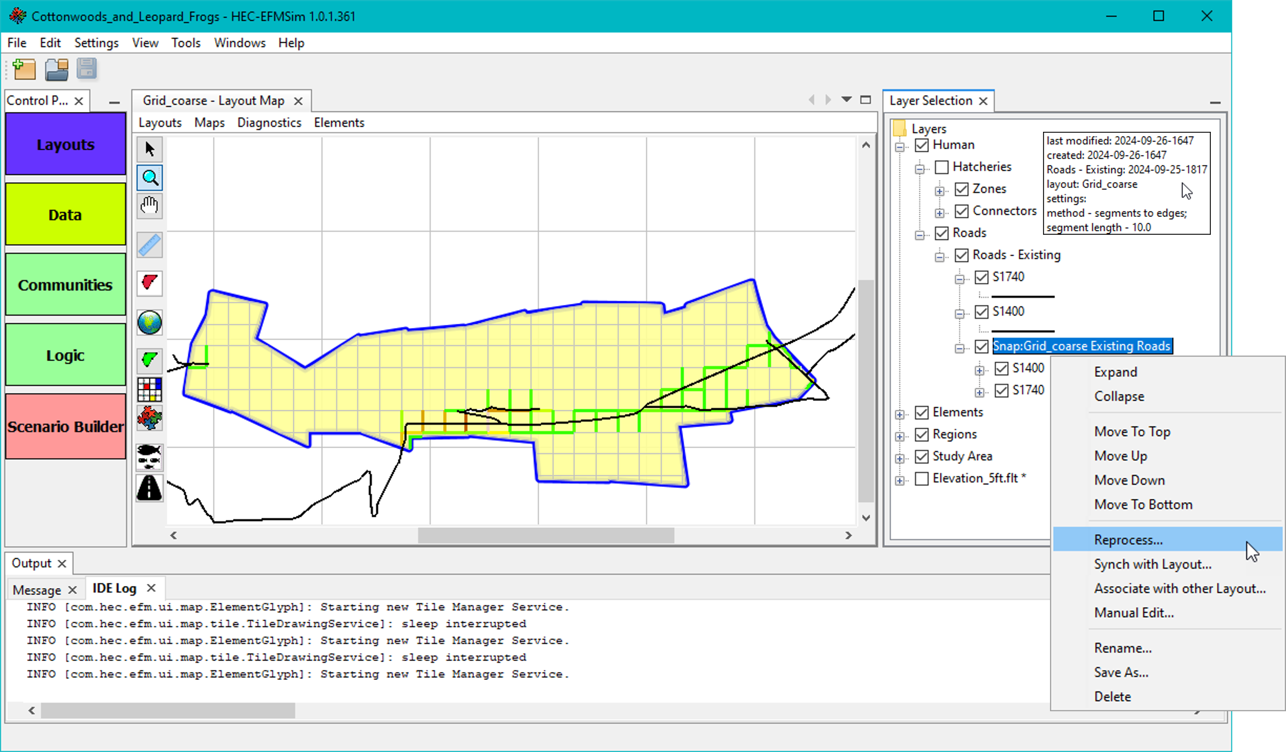
Snap maps are related to particular road maps and layouts and therefore can become out of sync as those are changed by the user. Several right click menu options are provided for working with snap maps (Figure).

Figure. Right click menu options for a snap map.
Reprocess… opens a modified version of the Create Snap Map interface that is populated with the settings used when the snap map was most recently processed. Name and layout settings cannot be updated. Reprocessing is done with the current copies of the road map and layout. Reprocessing is functionally the same as creating a new snap map and deleting the existing snap map. This option is most applicable when the existing snap map was created (and not manually edited) and then the associated road map or layout was changed.
Synch with Layout… splits and floats road-associated element edges from a previous version of the layout to the current version of the layout. This option is most applicable when the existing snap map was created and manually edited and then the associated layout was changed.
Associate with other Layout… splits and floats road-associated element edges from the snap map’s current layout to a different layout selected by the user. This option is most applicable when the existing snap map was created and manually edited and then a different layout was created and is intended for use. Please note that this option is often irreversible. A safe approach would be to save the existing snap map as a new snap map and then associate the new snap map with a different layout.
Manual Edit… offers several options for working with snap maps. Users can edit all road types or select a specific road type to work with and view. There is a check box option called Work per element. When that option is on, road lengths on element faces can be moved only within the element that originally contained the road. When off, road lengths on element faces can be moved anywhere in the study area. Relocate - Drag and drop allows users to drag a percentage of road length on an element face to a different face. Relocate – Proportional allows users to redistribute road lengths on an element face proportionally per the distribution of road lengths stored in other road-associated element faces.