The user can add as many types of map layers as needed. However, the user must make sure that all map layers use the same origin and measurement units. In GIS jargon, all map layers must use the same projection.
When a map layer is added to an HEC-FIA project, the software reads the coordinates of points, lines, and polygons on the map layer and resets the geographic extents of the watershed to the smallest rectangle that contains all objects in the map layer. If a shapefile is used to import a stream alignment, the units of the stream alignment are based on the units of the projection.
To add a map layer:
From the Study Tree, right-click on the Map Layers folder. From the shortcut menu, click Add Map Layer, and the Select Map Layer to Add browser window opens.
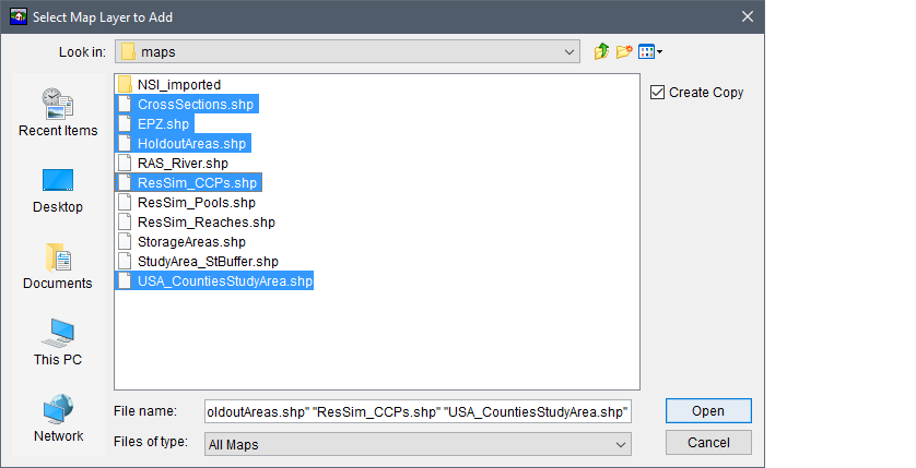
- Browse to the location where the map layers are located. Select an individual map layer by clicking on the filename, or add multiple map layers by holding down the CTRL key and selecting the map layers that could be part of the HEC-FIA project.
- Create Copy is selected by default and creates a copy of the selected files in the maps folder within the current study directory. Storing all the data in the project directory is recommended as this makes the project easier to store and share. If Create Copy is unchecked, the path to the file is stored relative to the project file; however, if either the map file itself, or the study project file is moved, HEC-FIA can no longer display the map file.
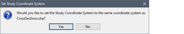
Once the necessary files are selected, click Open. The Select Map Layer to Add browser window closes. A Set Study Coordinate System window opens. The window is asking the user if the coordinate system for the HEC-FIA project should be set to the coordinate system of the first selected map layer (i.e., CrossSections.shp). Click Yes, if the coordinate system of the first selected map layer is correct. The Set Study Coordinate System window closes, and the map layers display in the map window.
- The filenames of the selected map layers display under the Map Layers folder in the Study Tree. To save the HEC-FIA project, from the toolbar click
 .
.