Stream Alignment
Stream alignments represent the stream system in the study. The alignment indicates where confluences and bifurcations occur and provides a sense of distance and scale. A stream alignment is a one-dimensional river coordinate system, which defines the natural downstream flow network. Stream alignments are composed of a stream centerline and a series of stream nodes, or vertex points. A stream typically begins or ends at a confluence, bifurcation, or at the boundary of the river system. A stream is composed of vertex points located along the stream centerline, with the beginning and ending vertex points being stream nodes. Also, from the stream centerline, stationing is provided relative to its global location and specific to the study.
In HEC-FIA a stream alignment is optional and is typically used when evaluating consequences by common computation points in CWMS (Corps Water Management System) or the HEC-WAT (Watershed Analysis Tool) software. Stream alignments used by HEC-FIA could possibly be developed in an HEC-ResSim (Reservoir System Simulation) model, or an HEC-RAS (River Analysis System) model.
Import a Stream Alignment
To import a stream alignment:
From the Study Tree, from the Watershed folder, right-click on the Stream Alignments folder. From the shortcut menu, click Import; the Import Stream Alignment dialog box opens.
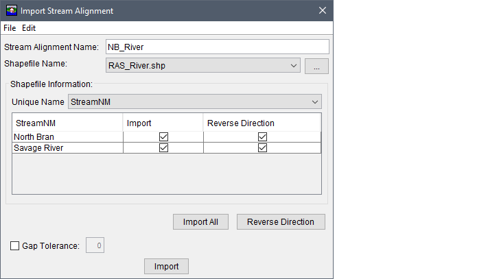
Figure: Import Stream Alignment Dialog Box - Example
- Enter a unique name for the stream alignment in the Stream Alignment Name text box.
- The Shapefile Name box lists the available shapefiles that have been added as map layers. If a map layer that represents a stream alignment has not been added to the HEC-FIA project, from the File menu, click Choose Shapefile; alternatively click the
 button. The Choose Shapefile browser window opens. Browse to the location of the shapefile that represents the stream alignment, select the filename (i.e., RAS_River.shp), and click Open. The Choose Shapefile browser window closes, and the Import Stream Alignment dialog box is populated with information from the selected shapefile.
 - From the Unique Name list, select the appropriate field name that contains the stream names. For example, in the figure above, StreamNM is the correct unique name for the stream names in the selected shapefile.
When the correct unique name has been selected, the table lists the unique stream names. If each stream is a contiguous line with one upstream point and one downstream point, then the checkbox in the Import column of the table is set. If something is wrong with the line that represents a stream, the checkbox will not be selected, and HEC-FIA does not import that stream element. This could be due to lines that are not continuous within one segment.
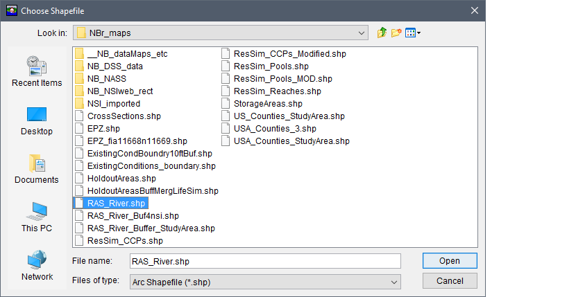
Figure: Choose Shapefile Browser Window
- By default, HEC-FIA assumes the downstream end of the river is at the beginning of each line segment, which is the first vertex point when the line shapefile was drawn. If the default assumption is not correct for the selected shapefile (i.e., RAS_River.shp) and the stream segments were drawn from the upstream end of the river to the downstream end, then the user can reverse the direction of the stream segment. Check the Reverse Direction checkbox for the incorrect stream segment (drawn from the upstream direction to the downstream direction) to import the stream alignment correctly.
- Click Import, the Import Stream Alignment dialog box closes. A message box appears when the stream alignment has been imported and the stream alignment displays in the active map window. The name of the stream alignment appears in the Study Tree under the Stream Alignments folder.
The stream alignment displays in the map window with assigned stationing. Stream stationing is assigned to a stream segment when the stream alignment is created, and HEC-FIA assumes the downstream end of the river (river station equal to zero) is at the beginning of each line segment that is when drawn is the first vertex in the line. Stationing should begin at the downstream end and ascend while proceeding upstream. HEC-FIA uses the units set by the coordinate system of the base shapefile. So, if horizontal units are in feet for the original shapefile, the stationing represents feet.
If the stream alignment appears with stationing of 0K (zero thousand units) at the upstream end of the alignment, then the stream alignment was imported incorrectly. To correct this issue from the Study Tree, from the Watershed folder, from the Stream Alignment folder, right-click on the stream alignment (e.g., NB_River). From the shortcut menu click Reverse Direction All and a Confirm Reverse Direction warning dialog box opens. Click Yes, to confirm and reverse the direction of all stream segments in the stream alignment.
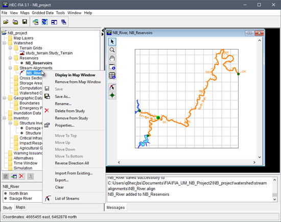
Figure: Stream Alignments Data - Study Tree Shortcut Commands
Changing the Stream Alignment
To make changes to the stream alignment, from the map window, select the Stream Alignment Tool ![]() . Using the Stream Alignment Tool a user can add stream segments to a stream alignment, and by right-clicking on a stream segment access the map window stream alignment shortcut menu. From the shortcut menu, a user can delete, rename, reverse the direction, disconnect the upstream or downstream ends, and edit stream segments.
. Using the Stream Alignment Tool a user can add stream segments to a stream alignment, and by right-clicking on a stream segment access the map window stream alignment shortcut menu. From the shortcut menu, a user can delete, rename, reverse the direction, disconnect the upstream or downstream ends, and edit stream segments. 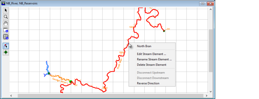
Figure: Map Window - Stream Alignment Tool - Shortcut Commands