Map Layer Formats
In HEC-FIA, digital maps are referred to as map layers. When a map layer is added to a study, the software displays it in the map window. HEC-FIA can use certain types of map layers as data sources. The map layer formats that HEC-FIA can display are listed in the table below.
|
|
USGS digital line graph | *.dlg |
AutoCAD® DXF | *.dxf |
ArcGIS® Shapefile | *.shp |
Raster image | *.png, *.jpg, *.gif, *.bmp |
ASCII NetTin | *.net |
USGS DEM | *.dem, *.flt |
Floating point binary | *.flt |
ArcGIS® Grid Exports | *.asc, |
LizardTech® MrSID® | *.sid |
HEC-FIA SMRMP | *.smrmp |
Open Street Maps | *.osm |
Virtual Format | *.vrt |
Typical data map layers required for a study include:
- Stream centerline shapefile (i.e., RAS_River.shp)
- Census block, parcel, or structure point shapefile (i.e., Census_Block_Clip.shp)
- Emergency planning zones shapefile (i.e., EPZ.shp)
Typical data map layers used but not required for a study include:
- Study Area shapefile (i.e., USA_CountiesStudyArea.shp)
- Cross Sections shapefile (i.e., CrossSections.shp)
- Storage Area shapefile (i.e., StorageAreas.shp)
- Computation Point shapefile (i.e., ResSim_CCPs.shp)
USGS Digital Line Graph (.dlg)
U.S. Geological Survey (USGS) Digital Line Graphs (DLGs) are created from two sources using manual and automated digitizing methods. The two sources are aerial photographs and cartographic sources. DLG files are vector representations of the data. When HEC-FIA interacts with a *.dlg file, it automatically creates a *.dlgbin file for use.
AutoCAD® DXF (.dxf)
A Drawing Interchange File (.dxf) is created by a Computer-Aided Design (CAD) package, AutoCAD®. This format is a tagged data representation of an AutoCad® drawing file. The .dxf format is commonly used for data exported from other CAD and GIS software.
ArcGIS® Shapefiles (.shp)
This file type is the native data structure for the ArcGIS® software. Shapefiles store non-topological geometry and attribute information for the spatial features of a data set in a particular format. Usually there are four component files associated with a shapefile: *.dbf, *.shp, *.prj, and *.shx. The *.shp file contains the shapes (points, polylines, or polygons) that are displayed in the layer. Each shape has a record in the *.dbf file containing descriptive data called "attributes". The *.prj file contains the projection information for the shapefile. Finally, the *.shx file contains an index that links each shape to its record in the *.dbf file. For more information on shapefiles, see the ESRI Shapefile Technical Description available here: http://www.esri.com/library/whitepapers/pdfs/shapefile.pdf.
Raster Image
The raster image formats supported by HEC-FIA are: JPEG format (.jpg), Graphics Interchange Format (.gif), Portable Network Graphic (.png), and, bitmap (.bmp). To import a raster image:
From the Study Tree, which is in the Study Pane, right-click on the Map Layers folder. From the shortcut menu, click Import Image(s); an Open browser window opens.
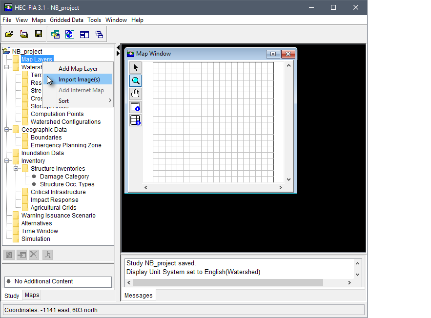
Figure: Study Tree - New Project - Map Layers Shortcut Menu
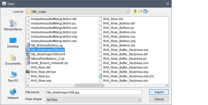
Figure: Open Browser Window
- Browse to the location of the image that is to be uploaded. Click on the name of image that could be used for the project. The name appears in the File name box. Click Import,
the Open browser closes and the Define Image Extents dialog box opens. Enter the extents of the image; once defined, click Finish. The filename of the selected image displays under the Map Layers folder in the Study Tree and the image file is stored in the maps folder of the study directory.
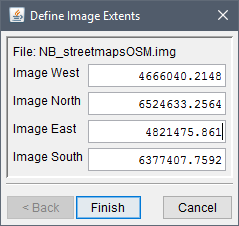
Figure: Define Image Extents Dialog Box
USGS DEM (.dem)
The U.S. Geological Survey (USGS) published the file format USGS DEM (as of 2006 USGS no longer directly distributes elevation data in the DEM format). A raster file format, *.dem files usually contain terrain elevations, but the file format can be used for representing any surface. The format, published by the USGS, allows internal documentation of coordinate system, date of publication, etc. These values are referenced horizontally, either to a Universal Transverse Mercator (UTM) projection or to a geographic coordinate system.
Floating Point Binary (.flt)
The .flt file is a similar format (ESRI binary grid file), but split into two files: an ASCII header (.hdr) file and an .flt file which contains binary representations of the cell values. The binary file (.flt) contains 32-bit floating data that is stored line by line from north to south (topological elevation values). The *.hdr file contains the geo-referencing information. Both files need to be stored in the same place.
ArcGIS® Grid Exports (.asc)
The *.asc file is an ASCII file format representation of a grid. The file consists of keywords followed by values defining the number of columns, number of rows, lower left corner, cell size, no data value, and each cell value.
HEC-FIA SMRMP (.smrmp)
The Segmented Multi-Resolution Multi-Parameter (SMRMP) file was created to operate gridded data (namely, digital terrain grids, inundation depth grids, and arrival time grids) more efficiently in HEC-FIA. When users add terrain and inundation data (see Terrain Grids), the user is prompted to convert to SMRMP format. This file type is not recommended and is only being maintained for existing projects which have the *.smrmp format a conversion tool to export to any another file format is not available.
ASCII NetTin (.net)
This is an ASCII file format used to represent a triangulated irregular network (TIN). TIN data are stored in a simple format that defines the nodes, edges, and triangles contained in the TIN. This format is common for transferring TIN data between software.
LizardTech® MrSID® (.sid)
MrSID® (multi-resolution seamless image database) is a propriety geo-referenced image file format developed by LizardTech® for use with geographic information systems (GIS). This format compresses large raster image files like aerial photographs or satellite imagery for easier viewing. Some MrSID images contain geo-referencing and positioning information which can be placed in the watershed.
Open Street Maps (.osm)
An XML file created by RMA to store user preferences regarding streaming services. This file is generated by HEC-FIA in the project's maps directory (see Chapter 3 for the HEC-FIA project file directory structure). This file should not be edited by the user.
Virtual Format (.vrt)
The *.vrt format is a format driver for GDAL (Geospatial Data Abstraction Library) and allows for a virtual GDAL dataset to be composed of other GDAL datasets. The primary use of this format is to group a series of grids that should be associated together. This file format allows multiple depth grids for the same event to create a mosaic single grid. Relative file paths are saved in an XML format, as well as a histogram describing the frequency of cell values across all grids within the *.vrt.