Download PDF
Download page HEC-Vortex, a Collection of Lightweight Data Processing Utilities Targeted for HEC Applications.
HEC-Vortex, a Collection of Lightweight Data Processing Utilities Targeted for HEC Applications
By Thomas Brauer, P.E.
As a junior engineer with the Hydrologic Engineering Center's Hydraulic Modeling System (HEC-HMS) team, I frequently fielded technical support requests related to applying various gridded datasets in HEC software. I quickly discovered the abundance of gridded datasets the National Aeronautics and Space Administration (NASA), National Oceanic and Atmospheric Administration (NOAA), European Centre for Medium-Range Weather Forecasts (ECMWF) and others were producing. The datasets seemed promising but there was an apparent gap in our ability to rapidly read the data in, and use it in our models. HEC-Vortex was born to fill this void.
HEC-Vortex addressed several technical challenges. At the highest level, a conversion between file formats is required. Many of the new gridded data products use modern file formats such as Network Common Data Form (netCDF), Hierarchical Data Format (HDF), and GRIdded Binary (Grib). The long-standing file format of HEC tools is HEC's Data Storage System (HEC-DSS). The core of HEC-Vortex functionality is to read data from various formats and save the data into an HEC-DSS file. Eventually, we would like to see HEC software handle more alternative datasets directly with no conversion to HEC-DSS required.
All things considered, reading and writing to different file formats is the easy part because open source libraries like netCDF and GDAL address the low-level input/output functionality. The difficult part is data handling, in all of its complicated forms. As part of data handling, HEC-Vortex takes on the technical challenges of handling coordinate systems, grid conventions, and unit systems, among others. When it comes to development, there is no substitute for heavy testing to reveal all of the edge cases that were not considered during initial implementation.
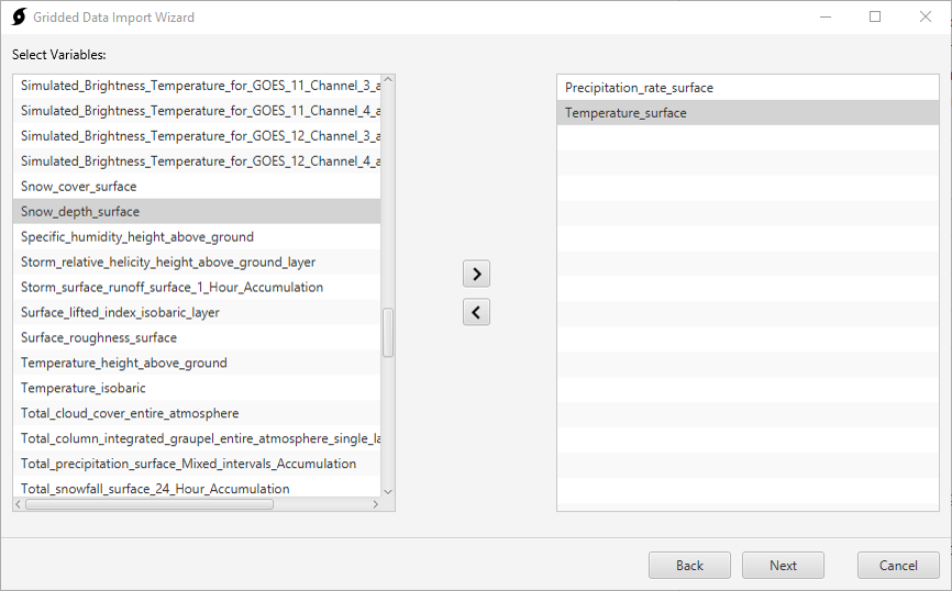
The core functionality of HEC-Vortex is embodied in the importer utility. The second step of the importer utility is shown in Figure 1. In this example, precipitation and temperature grids have been selected for import from a High Resolution Rapid Refresh (HRRR) dataset.

Several other lightweight utilities have come as a part of the research and development process. The current array of HEC-Vortex utilities are summarized below:
- The importer utility takes NetCDF, Grib, HDF, ASC, BIL, or HEC-DSS files as input, gives the user options for clipping, re-projecting, and resampling data, and writes to HEC-DSS format.
- The grid-to-point-converter utility converts gridded data to basin-average time-series data.
- The image-exporter utility exports gridded data to GeoTIFF or ASC raster formats.
- The transposer utility rotates and shifts grids spatially.
- The time-shifter utility shifts grids in time.
- The normalizer utility normalizes volumes from one set of grids to another, e.g., normalize hourly NOAA Next Generation Weather Radar (NEXRAD) Quantitative Precipitation Estimation (QPE) grids to daily Parameter-elevation Regressions on Independent Slopes Model (PRISM) grids.
- The travel-length-grid-cell-exporter utility converts an HEC-HMS mod-Clark grid cell file (*.mod) to a shapefile.
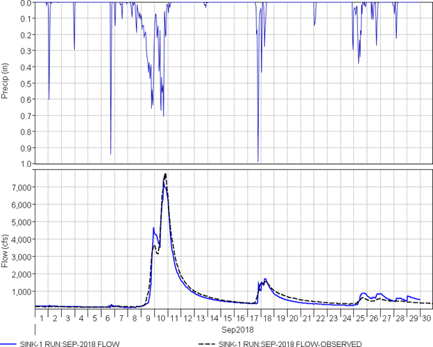
The results yielded from the HEC-Vortex project are noteworthy. One example is with Multi-radar, Multi-sensor (MRMS) precipitation and Real-time mesoscale analysis (RTMA) temperature products. Simulated flow results from HEC-HMS are improved for cases where we have applied MRMS precipitation and RTMA temperature products to calibrated continuous hydrologic models. Figure 2 displays a continuous calibration in the Punxsutawney basin using MRMS precipitation and RTMA temperature data. The biggest limitation of MRMS and RTMA data is availability. NOAA distributes the data real-time but does no archiving. The most abundant, publicly accessible, archive is found on the Iowa State Mesonet site; the archive covers 2014 to present.

Another promising data source is NASA’s remotely-sensed Global Precipitation Measurement (GPM) dataset. This dataset is an ancestor of NASA's Tropical Rainfall Measurement Mission (TRMM). In its modern form, the dataset covers the globe at a temporal resolution of 30 min and extends from June 2000 to present. We have seen this dataset capture short burst convective precipitation in the desert southwest for a time period where no other dataset was capable. Given the temporal and spatial extent of GPM data, we anticipate this will be helpful for modeling in locations outside of the United States.
The number of datasets that we have tested for simple import functionality is much greater than those we have been able to test in actual hydrologic modeling applications. Our hope is that users will use the HEC-Vortex utilities to test datasets and share successes or shortcomings. A non-comprehensive list of tested datasets includes: NOAA MRMS, NOAA RTMA, NOAA HRRR, NOAA Global Forecast System (GFS), NOAA Climate Prediction Center (CPC), NOAA Climate Prediction Center morphing technique (CMORPH), NASA GPM, NASA North American Land Data Assimilation System (NLDAS), PRISM, DayMet, and ECMWF Interim. We hope HEC-Vortex will eliminate the technical barriers to applying gridded datasets in HEC products while also yielding more accurate models, calibrated against high-resolution, spatially-distributed, data.
The HEC-Vortex utilities have been incorporated directly within HEC-HMS v4.9, streamlining the workflow for incorporating gridded hydrometeorologic data into a model. HEC-HMS leverages the same libraries that were developed in the standalone version of HEC-Vortex.
HEC-Vortex is open source software. Feel free to download the latest builds or view source code at the Hydrologic Engineering Center’s github page: https://github.com/HydrologicEngineeringCenter/Vortex.
To see HEC-Vortex in action with HEC-HMS you can view a recent webinar with the Australian Water School here: https://youtu.be/_cw28gRwxeY. Alternatively, view the Creating Gridded Boundary Conditions for HEC-HMS Tutorial, that provides users with a guide for creating a gridded precipitation boundary condition using the Vortex Importer utility.
If you have any comments or suggestions, or you are interested in contributing to the project please contact Tom Brauer (thomas.brauer@usace.army.mil).